KMSS

MASSENA INTL-RICHARDS FIELD
MASSENA
NY
Time Zone: Eastern
Lat: N 4456.2
Long: W 07450.7
Elev: 221
Var: +14
Longest Runway: 5601
AWOS: 128.07
CTAF: 123.0

FBO & Flight Services info for KMSS

FBOs: Update your Fuel Prices

TOWN OF MASSENAPh: 315-769-7605 Fax: 315-769-5445 Freq: 123.0
Service
Jet
100LL
SAF
MoGas
Fuel Avail: closed Sundays and Holidays
Full5.15      Caution: Fuel prices have not been updated in 42 days.
Last Update: 03/07/2024 14:26

Self  5.78    
 Address: 90 AVIATION RD,   MASSENA, NY 13662
ASOSPh: 315-764-0481
-
Freq: 128.07  
If you are an FBO, call 1-203-262-1700 to update your info or email: FltPlan.Advertising@garmin.com
Advertise your FBO on FltPlan.com

Runway & Approach Info for KMSS
Rwy
Length
Land Dist**
Approach*
  Rwy
Length
Land Dist**
Approach*
05
5601x100  5601'          
ILS
 108.70 - 045°  
  
23
  5601x100  5601'          
 
09
4000x100  4000'          
 
  
27
  4000x100  4000'          
 
 * only ILS, LOC, LDA, and SDF approaches to a specific runway are shown
** For any Declared Landing Distance Available, please see A/FD or Approach plates
Runway Weight Capability (lbs.) Help
Runway IDSingle WheelDouble WheelDouble Tandem WheelDual Double Wheel
05/2330,00050,00076,000N/A
09/2730,00050,00076,000N/A
These numbers are Advisory and are not limits.   The Airport Manager should have more accurate Weight Limits
Approach Charts
Approaches    
Current Weather/Notams
Customs Information Send updates to Support@FltPlan.com
Phone 315-769-3091
Fax 315-769-3146

Comments 1 hr advance notice required. Business hrs 0800-2400 7 days a week. *Cargo coverage upon prior arrangement
Database effective 04/18/2024
Airport Diagram of KMSS
Airport Diagram might not be current.

Facility Name: MASSENA INTL-RICHARDS FLD
City Name: MASSENA
County: ST LAWRENCE
State abbrev: NY
State Name: NEW YORK
   
Ownership: PUBLICLY OWNED
Use: OPEN TO THE PUBLIC
Owner's Name: TOWN OF MASSENA
Address: MAIN ST - TOWN HALL
 MASSENA, NY 13662
Owner's Phone: 315-769-3588
  
Manager's Name: DYLAN CASSELMAN
Address: 90 AVIATION ROAD
 MASSENA, NY 13662
Phone: 315-769-7429
   
FAA Region: EASTERN
FAA Field Office: NYC


Sunrise / Sunset times for MASSENA INTL-RICHARDS FLD

DateSunriseSunset
04/17/24 Wednesday6:1019:48
04/18/24 Thursday6:0819:50
04/19/24 Friday6:0719:51
04/20/24 Saturday6:0519:52
04/21/24 Sunday6:0319:53
04/22/24 Monday6:0219:55
04/23/24 Tuesday6:0019:56
04/24/24 Wednesday5:5819:57
04/25/24 Thursday5:5719:58
04/26/24 Friday5:5520:00
04/27/24 Saturday5:5420:01
04/28/24 Sunday5:5220:02
04/29/24 Monday5:5120:03
04/30/24 Tuesday5:4920:05

Airport Facilities

Airport Attendance ScheduleMON-FRI 0400-1700
Airport Status OPERATIONAL (This Status can change at any time - please check NOTAMS)
Airport Lighting ScheduleACTVT REIL RWY 05, 09 & 27; PAPI RWY 05, 23, 27; HIRL RWY 05/23; MIRL RWY 09/27; TWY LGTS - CTAF.
Airport Storage AvailableTie Downs, Hanger
Extra Services AvailableAir Freight, Cargo Handling, Charter
Wind IndicatorYES - (lighted)
Control TowerNO
CTAF Frequency123.000
Unicom Frequency123.000
Rotating Beacon ColorWG
Segmented CircleNO
Landing FeeYES

Airport Inspection Data

Airport InspectedFEDERAL - performed by FAA AIRPORTS FIELD PERSONNEL
Inspection Date04/03/2023

Airport Services

Type of Fuel AvailableGrade 100LL, JET A (freeze point -40C)
Airframe Repair ServiceMINOR
Power Plant Repair ServiceNONE

Geographic Data

LatitudeN4456.2
LongitudeW07450.7 (ESTIMATED)
Arpt Elevation221ft (SURVEYED)
Magnetic Variation14W
2 miles Eof MASSENA
Traffic Pattern Altitude
Sectional ChartMONTREAL

Aircraft Data

Operations (Reported)YearlyAvg. Daily
General Aviation Transient 460013
General Aviation Local 15004
Air Taxi 21906
Commerical 00
Commuter 00
Military 9002
Aircraft based on Field
General Aviation Singles 7
General Aviation Multi 0
Jet Aircraft 0
General Aviation Helicopters 0
Military Aircraft 0
Gliders 0
Ultralights 0

FAA Services

FSS on field NO
FSS tie-in BURLINGTON
FSS Phone 1-800-WX-BRIEF
Who issues Notams MSS
Notam D service at airport YES
ARTCC Name BOSTON

Federal Status

Airport CertificationAIRPORT RECEIVING SCHEDULED AIR CARRIER SERVICE FROM CARRIERS CERTIFICATED BY THE CIVIL AERONAUTICS BOARD; PPR 24 HRS FOR ACFT OPS WITH MORE THAN 30 PAX SEATS CALL AMGR (315) 769-7605.
Aircraft Rescue & Firefighting IndexAIRPORT HAS A CERTIFICATE UNDER CFR PART 139
Airport of EntryYES
Custom Landing RightsNo
Joint Civil/MilitaryNo
Military Landing rightsYES

Federal Agreements

NATIONAL PLAN OF INTEGRATED AIRPORT SYSTEMS (NPIAS)
GRANT AGREEMENTS UNDER FAAP/ADAP/AIP
ASSURANCES PURSUANT TO TITLE VI, CIVIL RIGHTS ACT OF 1964
AGREEMENT UNDER DLAND OR DCLA HAS EXPIRED.

Remarks

FREQUENT CONCENTRATION OF SEAGULLS AND CANADA GEESE ON AND INVOF ARPT PARTICULARLY DURG POOR WX PERIODS.
CTN NVD OPS CONDUCTED PERIODICALLY IN ARPT TFC PAT AREA.
MIL HEL TRNG ON & INVOF ARPT.
FOR CD IF UNA TO CTC ON FSS FREQ, CTC BOSTON ARTCC AT 603-879-6859 .
UNATTNDD SAT SUN AND HOL.
421 FT LGTD/MKD TWR 6000 FT S OF ARPT.
BIRDS & DEER ON & INVOF ARPT.
RY CONDS RPRTD DUR NML HRS OF OPN.
OVERNIGHT ACFT PARKING AVBL AT TERMINAL APRON.
AFTER ATTENDANCE HRS VEHICLE & PEDESTRIAN ACCESS TO FBO APRON & HANGAR ONLY AVBL WITH KEY CARD FOR AUTOMATIC GATE.
COMMUTER AIRCRAFT SECURE AREA CLOSED TO GENERAL AVIATION AIRCRAFT CLEARING CUSTOMS. PARKING AVAILABLE TO RIGHT OF TERMINAL BUILDING.
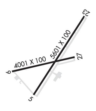
RWY 05/2 3 RWY 05 FIRST 50 FT NOT GRVD.
RWY 09/2 7 RWY 09 FIRST 50 FT NOT GRVD. RWY 27 FIRST 50 FT NOT GRVD.
Airport Communications & Frequencies:
CTAF Frequency:
123.000
Unicom Frequency:
123.000
Remarks
  • APCH/DEP SVC PRVDD BY BOSTON ARTCC ON FREQS 135.25/377.1 (TURIN RCAG).
  • Runway Identifications
    Runway Identification: 05/23
    Length: 5601 ft
    Width: 100 ft
    Surface: ASPHALT-GOOD CONDITION
    Edge lights: High Intensity

    Treatment: GROOVED
    Weight: PCN 18 /F/C/X/T

     Runway: 05   Runway: 23
    Mag heading: 45°Mag heading: 225°
    Rwy Slope: .32% UpRwy Slope: -.32% Down
    Approach: ILSApproach:
    Pattern: Left TrafficPattern: Left Traffic
    Markings: PRECISION INSTRUMENTMarkings: NONPRECISION INSTRUMENT
    Marking Condition: GOODMarking Condition: GOOD
    Arresting Dev: Arresting Dev:
    Lat & Long: N4455.8  W07451.0Lat. & Long.: N4456.6  W07450.3
    Elev: 203.3 ft. MSLElev: 221.4 ft. MSL
    TCH: 58 ft. AGLTCH: 43 ft. AGL
    Visual Glide Path: 3.00 degreesVisual Glide Path: 3.00 degrees
    Displaced Threshold: NoDisplaced Threshold: No
    Touchdown Zone: YESTouchdown Zone: YES
    Touchdown Elev.: 204.6 feetTouchdown Elev.: 221.4 feet
    Visual Glide Slope: 4-Light PAPI on LEFT side of RunwayVisual Glide Slope: 4-Light PAPI on LEFT side of Runway
    RVR Equipment: RVR Equipment:
    RVV Equipment: NORVV Equipment: NO
    Approach Lights: Approach Lights:
    REIL: YESREIL: NO
    Centerline Lights: NOCenterline Lights: NO
    Touchdown lights: NOTouchdown lights: NO
    Runway Category: Precision Instrument RunwayRunway Category: Runway with a Non-precision Approach having visibility minimums greater than 3/4 mile
    Declared Distances: TORA:5601' TODA:5601' ASDA:5601' LDA:5601'Declared Distances: TORA:5601' TODA:5601' ASDA:5601' LDA:5601'
    Obstructions: POLEObstructions:
    Marked: NOT Marked/LightedMarked:
    Clearance slope: 32:1Clearance slope: 50:1
    Obstruction height: 52 feet AGLObstruction height:
    Dist. from runway: 1649 feetDist. from runway:
    Centerline offset: 430 right of centerlineCenterline offset:
    Comments: Comments:
    Runway Identification: 09/27
    Length: 4000 ft
    Width: 100 ft
    Surface: ASPHALT-GOOD CONDITION
    Edge lights: Medium Intensity

    Treatment: GROOVED

     Runway: 09   Runway: 27
    Mag heading: 90°Mag heading: 270°
    Rwy Slope: .04% UpRwy Slope: -.04% Down
    Approach: Approach:
    Pattern: Left TrafficPattern: Left Traffic
    Markings: NONPRECISION INSTRUMENTMarkings: NONPRECISION INSTRUMENT
    Marking Condition: GOODMarking Condition: GOOD
    Arresting Dev: Arresting Dev:
    Lat & Long: N4456.1  W07451.3Lat. & Long.: N4456.2  W07450.4
    Elev: 202.9 ft. MSLElev: 204.5 ft. MSL
    TCH: TCH: 35 ft. AGL
    Visual Glide Path: Visual Glide Path: 3.00 degrees
    Displaced Threshold: NoDisplaced Threshold: No
    Touchdown Zone: YESTouchdown Zone: YES
    Touchdown Elev.: 204.6 feetTouchdown Elev.: 204.6 feet
    Visual Glide Slope: Visual Glide Slope: 4-Light PAPI on LEFT side of Runway
    RVR Equipment: RVR Equipment:
    RVV Equipment: NORVV Equipment: NO
    Approach Lights: Approach Lights:
    REIL: YESREIL: YES
    Centerline Lights: NOCenterline Lights: NO
    Touchdown lights: NOTouchdown lights: NO
    Runway Category: Runway with a Non-precision Approach having visibility minimums greater than 3/4 mileRunway Category: Runway with a Non-precision Approach having visibility minimums greater than 3/4 mile
    Declared Distances: TORA:4000' TODA:4000' ASDA:4000' LDA:4000'Declared Distances: TORA:4000' TODA:4000' ASDA:4000' LDA:4000'
    Obstructions: TREESObstructions:
    Marked: NOT Marked/LightedMarked:
    Clearance slope: 20:1Clearance slope: 34:1
    Obstruction height: 88 feet AGLObstruction height:
    Dist. from runway: 1764 feetDist. from runway:
    Centerline offset: 365 left of centerlineCenterline offset:
    Comments: Comments:
    C:27/P: