No landing fees, ramp fees,  or delays

KMSP

Whisper PlateWhisper Track
MINNEAPOLIS-ST. PAUL INTL.
MINNEAPOLIS
MN
Time Zone: Central
Lat: N 4452.9
Long: W 09313.3
Elev: 842
Var: -00
Longest Runway: 11006
Clr Del: 133.2
Dept. ATIS: 120.8
Arr. ATIS: 135.35
Ground: N121.8 S121.9
Tower: 123.95/126.7

FBO & Flight Services info for KMSP

FBOs: Update your Fuel Prices

  click here  
The Twin Cities is one of the largest commercial centers between the East and West coasts. The metropolitan area has a strong and diversified economy. With superior FBO services, Signature-Minneapolis maintains a reputation for providing the ultimate in executive aviation service to the Twin Cities.
Ph: 612-726-5700 Fax: 612-726-5032 Freq: 128.95WebsiteE-Mail
                   
Service
Jet
100LL
SAF
MoGas
Fuel Avail: 24-7. Jet A w/Prist, add $0.03 per gallon.
Full9.037.40    Last Update: 04/19/2024 07:53

Self        
Misc. Info: Colt, UVAir, Avfuel contract fuel available. Volume discountsAddress: 3800 EAST 70TH STREET,   MINNEAPOLIS, MINNESOTA 55450

ASOSPh: 612-725-0939
-
-
 
ATISPh: 612-726-9240
-
-
 
If you are an FBO, call 1-203-262-1700 to update your info or email: FltPlan.Advertising@garmin.com
Advertise your FBO on FltPlan.com
FBOs at nearby airports who want your business:
KSTP

St. Paul Flight Center is your premier FBO that offers a full range of services in a comfortable and safe setting that is situated just minutes from both Minneapolis and St. Paul's business districts. Every detail of your stay will be handled in a friendly and courteous manner by our well trained and professional staff with an average of over 15 years experience.
Ph: 800-368-0107 WebsiteE-MailFax: 651-227-6195 Freq: 129.0
KFCM


  click here  
Premier Jet Center, an IS-BAH-certified and CAA-preferred FBO at Flying Cloud Airport, offers full concierge, ground support, heated hangar space (up to G650/Global), de-ice capabilities, and more! Our experienced customer service team will ensure the highest quality of service while providing safe and efficient ground support. Call us for your next trip to Minneapolis. NO ramp or facility fees!
Ph: 952-641-2020 WebsiteE-MailFax: 952-641-2022 Freq: 130.62

Runway & Approach Info for KMSP
Rwy
Length
Land Dist**
Approach*
  Rwy
Length
Land Dist**
Approach*
04
11006x150  9456'          
ILS
 109.30 - 045°  
  
22
  11006x150  10006'          
LOCALIZER
 110.50 - 225°  
12L
8200x150  8200'          
ILS/DME
 110.70 - 121°  
  
30R
  8200x150  8000'          
ILS/DME
 110.70 - 301°  
12R
10000x200  10000'          
ILS/DME
 110.30 - 121°  
  
30L
  10000x200  10000'          
ILS/DME
 110.30 - 301°  
17
8000x150  8000'          
LOC/DME
 110.95 - 169°  
  
35
  8000x150  8000'          
ILS/DME
 110.95 - 349°  
 * only ILS, LOC, LDA, and SDF approaches to a specific runway are shown
** For any Declared Landing Distance Available, please see A/FD or Approach plates
Runway Weight Capability (lbs.) Help
Runway IDSingle WheelDouble WheelDouble Tandem WheelDual Double Wheel
04/22100,000200,000400,000850,000
12L/30R100,000200,000400,000850,000
12R/30L100,000200,000400,000850,000
17/35100,000200,000400,000850,000
These numbers are Advisory and are not limits.   The Airport Manager should have more accurate Weight Limits
Approach Charts
Approaches    
Current Weather/Notams
Customs Information Send updates to Support@FltPlan.com
Phone 612-725-3690
Fax 612-725-3842

Comments 1 hr advance required. Business hrs 0800-1700 Monday-Saturday. Email 3501-landingrights@cbp.dhs.gov
Database effective 04/18/2024
Airport Diagram of KMSP
Airport Diagram might not be current.

Facility Name: MINNEAPOLIS-ST PAUL INTL/WOLD-CHAMBERLAIN
City Name: MINNEAPOLIS
County: HENNEPIN
State abbrev: MN
State Name: MINNESOTA
   
Ownership: PUBLICLY OWNED
Use: OPEN TO THE PUBLIC
Owner's Name: METRO ARPT CMSN
Address: 6040 28TH AVE S
 MINNEAPOLIS, MN 55450-2799
Owner's Phone: 612-726-8100
  
Manager's Name: BRIAN RYKS
Address: 6040 28TH AVE S
 MINNEAPOLIS, MN 55450-2799
Phone: 612-726-8100
   
FAA Region: GREAT LAKES
FAA Field Office: DMA


Sunrise / Sunset times for MINNEAPOLIS-ST PAUL INTL/WOLD-CHAMBERLAIN

DateSunriseSunset
04/19/24 Friday6:2020:04
04/20/24 Saturday6:1920:05
04/21/24 Sunday6:1720:07
04/22/24 Monday6:1520:08
04/23/24 Tuesday6:1420:09
04/24/24 Wednesday6:1220:10
04/25/24 Thursday6:1020:12
04/26/24 Friday6:0920:13
04/27/24 Saturday6:0720:14
04/28/24 Sunday6:0620:15
04/29/24 Monday6:0420:17
04/30/24 Tuesday6:0320:18
05/01/24 Wednesday6:0120:19
05/02/24 Thursday6:0020:20

Airport Facilities

Airport Attendance ScheduleCONTINUOUS
Airport Status OPERATIONAL (This Status can change at any time - please check NOTAMS)
Airport Lighting Schedule
Airport Storage AvailableTie Downs, Hanger
Extra Services AvailableAir Freight, Avionics, Cargo Handling, Charter
Wind IndicatorYES - (lighted)
Control TowerYES
CTAF Frequency
Unicom Frequency122.950
Rotating Beacon ColorWG
Segmented CircleNO
Landing FeeYES

Airport Inspection Data

Airport InspectedFEDERAL - performed by FAA AIRPORTS FIELD PERSONNEL
Inspection Date08/24/2023

Airport Services

Type of Fuel AvailableGrade 100LL, JET A (freeze point -40C)A++; -10FUEL CIV RAMP A+; NC-100LL - 612-726-5700.; -A+FUEL MIL RAMP - MILOPS.
Airframe Repair ServiceMAJOR
Power Plant Repair ServiceMAJOR

Geographic Data

LatitudeN4452.9
LongitudeW09313.3 (ESTIMATED)
Arpt Elevation841ft (SURVEYED)
Magnetic Variation00E
6 miles Sof MINNEAPOLIS
Traffic Pattern Altitude
Sectional ChartTWIN CITIES

Aircraft Data

Operations (Reported)YearlyAvg. Daily
General Aviation Transient 834523
General Aviation Local 00
Air Taxi 39695109
Commerical 260910715
Commuter 00
Military 19585
Aircraft based on Field
General Aviation Singles 0
General Aviation Multi 26
Jet Aircraft 136
General Aviation Helicopters 0
Military Aircraft 16
Gliders 0
Ultralights 0

FAA Services

FSS on field NO
FSS tie-in PRINCETON
FSS Phone 1-800-WX-BRIEF
Who issues Notams MSP
Notam D service at airport YES
ARTCC Name MINNEAPOLIS

Federal Status

Airport CertificationAIRPORT RECEIVING SCHEDULED AIR CARRIER SERVICE FROM CARRIERS CERTIFICATED BY THE CIVIL AERONAUTICS BOARD
Aircraft Rescue & Firefighting IndexAIRPORT HAS A CERTIFICATE UNDER CFR PART 139
Airport of EntryNo
Custom Landing RightsYES
Joint Civil/MilitaryNo
Military Landing rightsYES

Federal Agreements

NATIONAL PLAN OF INTEGRATED AIRPORT SYSTEMS (NPIAS)
GRANT AGREEMENTS UNDER FAAP/ADAP/AIP
SURPLUS PROPERTY AGREEMENT UNDER PUBLIC LAW 289
SURPLUS PROPERTY AGREEMENT UNDER REGULATION 16-WAA
CONVEYANCE UNDER SCETION 16, FEDERAL AIRPORT ACT OF 1946 OR SECTION 23, AIRPORT AND AIRWAY DEVELOPMENT ACT OF 1970
ASSURANCES PURSUANT TO TITLE VI, CIVIL RIGHTS ACT OF 1964

Remarks

TRNG FLTS PROHIBITED. GA FLTS MUST TRMT AT THE FBO OR US CUSTOMS UNLESS APVD BY AMGR.
133 AW AFLD MGMT - 324.1 REMARKS: CALL LIGHTHOUSE.
COMMUNICATIONS: MINNEAPOLIS AIR RESERVE STATION JOINT COMD POST - 252.1 REMARKS: CALL NORTHSTAR.
934 AW AFLD MGMT - PTD 282.675 REMARKS: CALL VIKING OPS.
REMARKS: ALL ACFT MUST CTC NORTHSTAR ON FREQ 252.1 20 MIN PRIOR ARR.
ASDE-X IN USE; OPR TRANSPONDERS WITH ALT RPRT MODE & ADS-B ENABLED ON ALL ARPT SFCS.
UNSKED ACFT AT TRML 2-HUMPHREY REQ TO CTC TRML 2 GATE CONTROL ON 122.95 OR CALL 612-726-5742 PRIOR TO ARR.
NOISE ABATEMENT PROCEDURES - 612-726-9411. NO STAGE 1 CAT CIVIL ACFT. NIGHT HR 2230-0600.
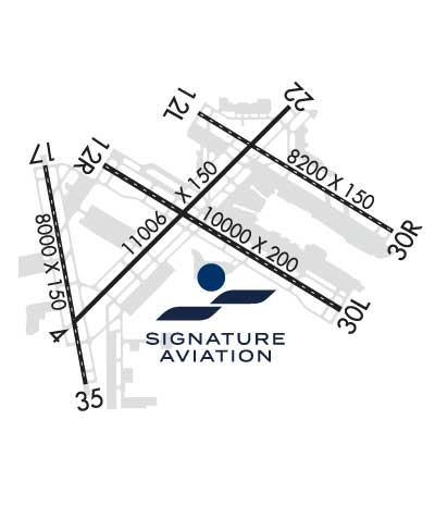
ALL GROUP VI ACFT WITH WINGSPAN GREATER THAN 214 FT PPR REQ PRIOR TO ARR - CTC AIRSIDE OPS 612-726-5111.
RWY STATUS LGTS IN OPRN.
ALL GA ACFT WITH LESS THAN 20 PAX THAT NEED TO CLEAR US CUSTOMS SHOULD CTC SIGNATURE FLT SUPPORT 128.95 OR 612-726-5700 PRIOR TO ARR.
ALL GROUP IV AND LRGR ACFT OPRG ON THE PTN OF TWY S ADJ TO DELTA BLDG C RQR THE USE OF WINGWALKERS AND THAT THE VEHICLE SVC ROAD BE CLEAR OF VEHICLES.
BIRDS ON & INVOF ARPT.
SIGNATURE FLIGHT SUPPORT 128.95
MILITARY: ARFC 934 AW OPS 1300-0400Z++ MON-THUR, 1300-2200Z++ FRI, CLSD WKEND AND FEDERAL HOL. UNIT TRNG ASSEMBLY (UTA) WKEND 1330-2200Z++. ALL TRANS ACFT MUST RECEIVE PPR 48 HR PRIOR TO ETA - CTC AIRFIELD MGMT.
MILITARY RSTD: NO HAZ CL/DIV1.1 OR 1.2 EXPLOSIVES PERMITTED. LOADING OR UNLOADING OF HAZ CL/DIV 1.3, 1.4, 1.5 0R 1.6 MUST BE APV BY ARPT DRCT PRIOR TO FLT.
Airport Communications & Frequencies:
ATIS Frequencies:   Hours(local) of Operation: CONTINUOUS
120.8 ;DEP
135.35 ;ARR
239.275 ;ARR
MINNEAPOLIS Tower Frequencies:   Hours(local) of operation: CONTINUOUS   
123.675 ;RWY 17/35
123.95 ;RWY 12L/30R
126.7 ;RWY 04/22, 12R/30L
273.55
MINNEAPOLIS Ground Frequencies:
121.8 ;N
121.9 ;S
127.925 ;W
133.575
348.6
Clearance Delivery Frequencies:
133.2
Pre-Taxi Clearance Frequencies:
133.2
Emergency Frequencies:
121.5
243.0
Unicom Frequency:
122.950
MINNEAPOLIS Primary Approach Frequencies:  
118.725 RWY 35
119.3 RWY 04/22, 12L/30R, 17
126.95 RWY 12R/30L
335.5
335.65
MINNEAPOLIS Primary Departure Frequencies:  
124.7 SOUTH OR EAST OF ARR RWY
125.75 NORTH OR WEST OF ARR RWY
132.975 E OF DEP RWY 17
335.65
Part-time Departure Frequencies:  
284.7
Class B Frequencies:
121.2 NORTHEAST
126.5 NORTHWEST
134.7 SOUTH
Runway Identifications
Runway Identification: 04/22
Length: 11006 ft
Width: 150 ft
Surface: CONCRETE-GOOD CONDITION
Edge lights: High Intensity

Treatment: GROOVED
Weight: PCN 105/R/B/W/T

 Runway: 04   Runway: 22
Mag heading: 45°Mag heading: 225°
Rwy Slope: -.03% DownRwy Slope: .03% Up
Approach: ILSApproach: LOCALIZER
Pattern: Left TrafficPattern: Left Traffic
Markings: PRECISION INSTRUMENTMarkings: PRECISION INSTRUMENT
Marking Condition: GOODMarking Condition: GOOD
Arresting Dev: Arresting Dev:
Lat & Long: N4452.3  W09314.3Lat. & Long.: N4453.6  W09312.5
Elev: 833.5 ft. MSLElev: 830.3 ft. MSL
TCH: 76 ft. AGLTCH: 61 ft. AGL
Visual Glide Path: 3.00 degreesVisual Glide Path: 3.00 degrees
Displaced Threshold: 1550 feetDisplaced Threshold: 1000 feet
Touchdown Zone: YESTouchdown Zone: YES
Touchdown Elev.: 831.7 feetTouchdown Elev.: 828.3 feet
Visual Glide Slope: 4-Light PAPI on LEFT side of RunwayVisual Glide Slope: 4-Light PAPI on LEFT side of Runway
RVR Equipment: TOUCHDOWN-ROLLOUTRVR Equipment: TOUCHDOWN-ROLLOUT
RVV Equipment: NORVV Equipment: NO
Approach Lights: MALSR - 1,400 foot medium intensity approach lighting system with runway alignment indicator lightsApproach Lights: MALSR - 1,400 foot medium intensity approach lighting system with runway alignment indicator lights
REIL: NOREIL: NO
Centerline Lights: NOCenterline Lights: NO
Touchdown lights: NOTouchdown lights: NO
Runway Category: DRunway Category: D
Declared Distances: TORA:11006' TODA:11006' ASDA:11006' LDA:9456'Declared Distances: TORA:11006' TODA:11006' ASDA:11006' LDA:10006'
Obstructions: TREEObstructions: TREE
Marked: NOT Marked/LightedMarked: NOT Marked/Lighted
Clearance slope: 26:1; APCH RATIO 43:1 TO DTHR OVR 102 FT TREE, 4456 FT DIST, 834 FT L.Clearance slope: 17:1; APCH RATIO 34:1 TO DTHR OVR 70 FT TREE, 2337 FT DIST, 439 FT R.
Obstruction height: 101 feet AGLObstruction height: 66 feet AGL
Dist. from runway: 2906 feetDist. from runway: 1350 feet
Centerline offset: 834 left of centerlineCenterline offset: 636 feet right of centerline
Comments: Comments: 8 FT FENCE, 500 FT R.
Runway Identification: 12L/30R
Length: 8200 ft
Width: 150 ft
Surface: CONCRETE-FAIR CONDITION
Edge lights: High Intensity

Treatment: GROOVED
Weight: PCN 105/R/B/W/T

 Runway: 12L   Runway: 30R
Mag heading: 121°Mag heading: 301°
Rwy Slope: -.23% DownRwy Slope: .23% Up
Approach: ILS/DMEApproach: ILS/DME
Pattern: Left TrafficPattern: Left Traffic
Markings: PRECISION INSTRUMENTMarkings: PRECISION INSTRUMENT
Marking Condition: GOODMarking Condition: GOOD
Arresting Dev: Arresting Dev:
Lat & Long: N4453.6  W09313.3Lat. & Long.: N4452.9  W09311.6
Elev: 838.6 ft. MSLElev: 819.5 ft. MSL
TCH: 79 ft. AGLTCH: 71 ft. AGL
Visual Glide Path: 3.00 degreesVisual Glide Path: 3.00 degrees
Displaced Threshold: NoDisplaced Threshold: 200 feet
Touchdown Zone: YESTouchdown Zone: YES
Touchdown Elev.: 840.7 feetTouchdown Elev.: 822.4 feet
Visual Glide Slope: 4-Light PAPI on LEFT side of RunwayVisual Glide Slope: 4-Light PAPI on LEFT side of Runway
RVR Equipment: TOUCHDOWN-MIDFIELD-ROLLOUTRVR Equipment: TOUCHDOWN-MIDFIELD-ROLLOUT
RVV Equipment: NORVV Equipment: NO
Approach Lights: ALSF2 - standard 2,400 foot high intensity approach lighting system with sequenced flashers, Category II or IIIApproach Lights: MALSF - 1,400 foot medium intensity approach lighting system with sequenced flashers
REIL: NOREIL: NO
Centerline Lights: YESCenterline Lights: YES
Touchdown lights: YESTouchdown lights: NO
Runway Category: Precision Instrument RunwayRunway Category: Precision Instrument Runway
Declared Distances: TORA:8200' TODA:8200' ASDA:7620' LDA:7620'Declared Distances: TORA:8200' TODA:8200' ASDA:8200' LDA:8000'
Obstructions: TREEObstructions: TREE
Marked: NOT Marked/LightedMarked: NOT Marked/Lighted
Clearance slope: 46:1Clearance slope: 46:1
Obstruction height: 61 feet AGLObstruction height: 13 feet AGL
Dist. from runway: 3011 feetDist. from runway: 808 feet
Centerline offset: 667 right of centerlineCenterline offset: 272 feet right of centerline
Comments: Comments:
Runway Identification: 12R/30L
Length: 10000 ft
Width: 200 ft
Surface: CONCRETE-GOOD CONDITION
Edge lights: High Intensity

Treatment: GROOVED
Weight: PCN 106/R/B/W/T

 Runway: 12R   Runway: 30L
Mag heading: 121°Mag heading: 301°
Rwy Slope: -.27% DownRwy Slope: .27% Up
Approach: ILS/DMEApproach: ILS/DME
Pattern: Left TrafficPattern: Left Traffic
Markings: PRECISION INSTRUMENTMarkings: PRECISION INSTRUMENT
Marking Condition: GOODMarking Condition: GOOD
Arresting Dev: EMAS; ENGINEERED MATERIALS ARRESTING SYSTEM (EMAS) 160 FT IN LENGTH BY 216 FT IN WIDTH LCTD AT DER 12R.Arresting Dev:
Lat & Long: N4453.3  W09314.0Lat. & Long.: N4452.4  W09312.1
Elev: 841.8 ft. MSLElev: 814.4 ft. MSL
TCH: 66 ft. AGLTCH: 78 ft. AGL
Visual Glide Path: 3.00 degreesVisual Glide Path: 3.00 degrees
Displaced Threshold: NoDisplaced Threshold: No
Touchdown Zone: YESTouchdown Zone: YES
Touchdown Elev.: 841.8 feetTouchdown Elev.: 823.0 feet
Visual Glide Slope: 4-Light PAPI on LEFT side of RunwayVisual Glide Slope: 4-Light PAPI on LEFT side of Runway
RVR Equipment: TOUCHDOWN-MIDFIELD-ROLLOUTRVR Equipment: TOUCHDOWN-MIDFIELD-ROLLOUT
RVV Equipment: NORVV Equipment: NO
Approach Lights: ALSF2 - standard 2,400 foot high intensity approach lighting system with sequenced flashers, Category II or IIIApproach Lights: ALSF2 - standard 2,400 foot high intensity approach lighting system with sequenced flashers, Category II or III
REIL: NOREIL: NO
Centerline Lights: YESCenterline Lights: YES
Touchdown lights: YESTouchdown lights: YES
Runway Category: Precision Instrument RunwayRunway Category: Precision Instrument Runway
Declared Distances: TORA:10000' TODA:10000' ASDA:10000' LDA:10000'Declared Distances: TORA:10000' TODA:10000' ASDA:10000' LDA:10000'
Obstructions: Obstructions: TREE
Marked: Marked: LIGHTED
Clearance slope: 50:1Clearance slope: 35:1
Obstruction height: Obstruction height: 36 feet AGL
Dist. from runway: Dist. from runway: 1477 feet
Centerline offset: Centerline offset: 562 feet right of centerline
Comments: Comments:
Runway Identification: 17/35
Length: 8000 ft
Width: 150 ft
Surface: CONCRETE-GOOD CONDITION
Edge lights: High Intensity

Treatment: GROOVED
Weight: PCN 118/R/B/W/T

 Runway: 17   Runway: 35
Mag heading: 170°Mag heading: 350°
Rwy Slope: -.09% DownRwy Slope: .09% Up
Approach: LOC/DMEApproach: ILS/DME
Pattern: Left TrafficPattern: Left Traffic
Markings: NONPRECISION INSTRUMENTMarkings: PRECISION INSTRUMENT
Marking Condition: GOODMarking Condition: GOOD
Arresting Dev: Arresting Dev:
Lat & Long: N4453.3  W09314.5Lat. & Long.: N4452.0  W09314.2
Elev: 840.4 ft. MSLElev: 833.3 ft. MSL
TCH: 60 ft. AGLTCH: 71 ft. AGL
Visual Glide Path: 3.00 degreesVisual Glide Path: 3.00 degrees
Displaced Threshold: NoDisplaced Threshold: No
Touchdown Zone: YESTouchdown Zone: YES
Touchdown Elev.: 840.4 feetTouchdown Elev.: 834.4 feet
Visual Glide Slope: 4-Light PAPI on RIGHT side of RunwayVisual Glide Slope: 4-Light PAPI on LEFT side of Runway
RVR Equipment: TOUCHDOWN-MIDFIELD-ROLLOUTRVR Equipment: TOUCHDOWN-MIDFIELD-ROLLOUT
RVV Equipment: NORVV Equipment: NO
Approach Lights: Approach Lights: ALSF2 - standard 2,400 foot high intensity approach lighting system with sequenced flashers, Category II or III
REIL: YESREIL: NO
Centerline Lights: YESCenterline Lights: YES
Touchdown lights: NOTouchdown lights: YES
Runway Category: Runway with a Non-precision Approach having visibility minimums greater than 3/4 mileRunway Category: Precision Instrument Runway
Declared Distances: TORA:8000' TODA:8000' ASDA:8000' LDA:8000'Declared Distances: TORA:8000' TODA:8000' ASDA:8000' LDA:8000'
Obstructions: TREEObstructions:
Marked: NOT Marked/LightedMarked:
Clearance slope: 34:1Clearance slope: 50:1
Obstruction height: 52 feet AGLObstruction height:
Dist. from runway: 1990 feetDist. from runway:
Centerline offset: 732 right of centerlineCenterline offset:
Comments: Comments:
C:131/P: