KMSO

MISSOULA INTL
MISSOULA
MT
Time Zone: Mountain
Lat: N 4655.0
Long: W 11405.4
Elev: 3206
Var: -13
Longest Runway: 9501
Dept. ATIS: 126.65
Arr. ATIS: 126.65
AWOS: 121.9
Ground: 121.9
Tower: 118.4

FBO & Flight Services info for KMSO

FBOs: Update your Fuel Prices

  click here  
Welcome to Northstar Jet, Missoula's premier, full service FBO! From basic single engine trainers, to high end corporate jets, we have the facilities and personnel to handle your needs. Settle into our newly remodeled lobby and facilities while our NATA Safety 1st certified line crew takes care of your aircraft. Open 24 hours a day, we are happy to set up reservations ahead of time.
Ph: 800-735-4476 Fax: 406-721-8828 Freq: 123.3WebsiteE-Mail
                     
Service
Jet
100LL
SAF
MoGas
Fuel Avail: FSII+$0.10/gal Open 0400-2200, after hours call out service available, please call 406-781-8886
Full6.356.54    Last Update: 04/09/2024 13:18

Self  5.79    
Misc. Info: Red Carpet Service, NATA Safety 1st certified, Quick Turns and ammenities!
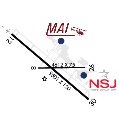
Address: 1 CORPORATE WAY,   MISSOULA, MT 59808

  click here  
Minuteman Jet Center is Missoula's preferred full-service flight support center! We're only minutes from downtown Missoula, the University of Montana, hotels, shopping and fine dining. Full concierge service; planeside transportation; best fuel prices; preferred hotel and rental car rates; courtesy cars. No ramp fees! Call 800-926-7481 or Unicom 122.95! Serving MSO for over 30 years!
Ph: 406-728-9363 Fax: 406-728-6981 Freq: 122.95WebsiteE-Mail
                     
Service
Jet
100LL
SAF
MoGas
Fuel Avail: PRIST+$0.08/gal 24 hrs, pls call (406) 240-8218
Full5.906.95    Last Update: 04/13/2024 11:49

Self        
Misc. Info: Full concierge, Quick turns, Avtrip Rewards, Everest Fuel, Volume fuel discounts over 200 gallons!Address: 6337 AVIATION WAY WEST,   MISSOULA, MT 59808

ASOSPh: 406-728-3743
-
Freq: 121.9  
If you are an FBO, call 1-203-262-1700 to update your info or email: FltPlan.Advertising@garmin.com
Advertise your FBO on FltPlan.com

Runway & Approach Info for KMSO
Rwy
Length
Land Dist**
Approach*
  Rwy
Length
Land Dist**
Approach*
08
4612x75  4612'          
 
  
26
  4612x75  4612'          
 
12
9501x150  9501'          
ILS
 109.30 - 117°  
  
30
  9501x150  9501'          
 
 * only ILS, LOC, LDA, and SDF approaches to a specific runway are shown
** For any Declared Landing Distance Available, please see A/FD or Approach plates
Runway Weight Capability (lbs.) Help
Runway IDSingle WheelDouble WheelDouble Tandem WheelDual Double Wheel
08/2630,00050,000N/AN/A
12/30145,000170,000255,000N/A
These numbers are Advisory and are not limits.   The Airport Manager should have more accurate Weight Limits
Approach Charts
Approaches    
Current Weather/Notams
Customs Information Send updates to Support@FltPlan.com
Customs Not Available
Database effective 05/16/2024
Airport Diagram of KMSO
Airport Diagram might not be current.

Facility Name: MISSOULA MONTANA
City Name: MISSOULA
County: MISSOULA
State abbrev: MT
State Name: MONTANA
   
Ownership: PUBLICLY OWNED
Use: OPEN TO THE PUBLIC
Owner's Name: MISSOULA CTY ARPT AUTH
Address: 5225 WEST BROADWAY
 MISSOULA, MT 59808
Owner's Phone: 406-728-4381
  
Manager's Name: BRIAN ELLESTAD
Address: 5225 WEST BROADWAY
 MISSOULA, MT 59808
Phone: 406-728-4381
   
FAA Region: NORTHWEST MOUNTAIN
FAA Field Office: HLN


Sunrise / Sunset times for MISSOULA MONTANA

DateSunriseSunset
04/24/24 Wednesday6:3120:38
04/25/24 Thursday6:2920:40
04/26/24 Friday6:2820:41
04/27/24 Saturday6:2620:42
04/28/24 Sunday6:2420:44
04/29/24 Monday6:2320:45
04/30/24 Tuesday6:2120:46
05/01/24 Wednesday6:2020:48
05/02/24 Thursday6:1820:49
05/03/24 Friday6:1720:50
05/04/24 Saturday6:1520:52
05/05/24 Sunday6:1420:53
05/06/24 Monday6:1220:54
05/07/24 Tuesday6:1120:56

Airport Facilities

Airport Attendance ScheduleCONTINUOUS
Airport Status OPERATIONAL (This Status can change at any time - please check NOTAMS)
Airport Lighting ScheduleWHEN ATCT CLSD ACTVT MALSR RWY 12; PAPI RWY 30; MIRL 08/26; HIRL RWY 12/30 - CTAF.
Airport Storage AvailableTie Downs, Hanger
Extra Services AvailableAir Freight, Air Ambulance, Avionics, Charter, Flight Instruction, Parachute Jumping, Aircraft Rental, Aircraft Sales
Wind IndicatorYES - (lighted)
Control TowerYES
CTAF Frequency118.400
Unicom Frequency122.950
Rotating Beacon ColorWG
Segmented CircleYES
Landing FeeYES

Airport Inspection Data

Airport InspectedFEDERAL - performed by FAA AIRPORTS FIELD PERSONNEL
Inspection Date02/29/2024

Airport Services

Type of Fuel AvailableGrade 100LL, JET A-1 (icing inhibitor, freeze point -50C)
Airframe Repair ServiceMAJOR
Power Plant Repair ServiceMAJOR

Geographic Data

LatitudeN4655.0
LongitudeW11405.4 (ESTIMATED)
Arpt Elevation3205ft (SURVEYED)
Magnetic Variation13E
4 miles NWof MISSOULA
Traffic Pattern Altitude
Sectional ChartGREAT FALLS

Aircraft Data

Operations (Reported)YearlyAvg. Daily
General Aviation Transient 998727
General Aviation Local 1742348
Air Taxi 541915
Commerical 865324
Commuter 00
Military 11993
Aircraft based on Field
General Aviation Singles 104
General Aviation Multi 12
Jet Aircraft 32
General Aviation Helicopters 26
Military Aircraft 0
Gliders 0
Ultralights 0

FAA Services

FSS on field NO
FSS tie-in GREAT FALLS
FSS Phone 1-800-WX-BRIEF
Who issues Notams MSO
Notam D service at airport YES
ARTCC Name SALT LAKE CITY

Federal Status

Airport CertificationAIRPORT RECEIVING SCHEDULED AIR CARRIER SERVICE FROM CARRIERS CERTIFICATED BY THE CIVIL AERONAUTICS BOARD
Aircraft Rescue & Firefighting IndexAIRPORT HAS A CERTIFICATE UNDER CFR PART 139
Airport of EntryNo
Custom Landing RightsNo
Joint Civil/MilitaryNo
Military Landing rightsYES

Federal Agreements

NATIONAL PLAN OF INTEGRATED AIRPORT SYSTEMS (NPIAS)
GRANT AGREEMENTS UNDER FAAP/ADAP/AIP
ASSURANCES PURSUANT TO TITLE VI, CIVIL RIGHTS ACT OF 1964
AGREEMENT UNDER DLAND OR DCLA HAS EXPIRED.

Remarks

CONTACT ARPT MANAGER TO REQUEST APPROVAL PRIOR TO ULTRALIGHT OPNS.
COLD TEMPERATURE AIRPORT. ALTITUDE CORRECTION REQUIRED AT OR BELOW -12C.
PRCHTG AT OR ARND THE ARPT.
TWY G BTN RWY 08 END TO RWY 12/30 RSTRD TO ACFT UNDER 12500 LBS.
LDG FEE FOR ALL COML ACFT AND ALL ACFT OVER 12,500 LBS.
MIGRATORY & SMALL BIRD ACTVTY ON & INVOF ARPT YEAR ROUND.
HANG GLIDER OPS, PARAGLIDER ACT 5.5 NM EAST OF AER RWY 30.
RWY 08/2 6 WHEN TWR CLSD RWY 08/26 CLSD EXC TAXI .
RWY 12/3 0 180 DEG TURNS FOR ACFT OVR 12500 LBS GWT PROHIBITED ON ALL MOVEMENT AREAS. AVOID LOCKED TURNS AT ALL TIMES.
Airport Communications & Frequencies:
ATIS Frequencies:   Hours(local) of Operation: CONTINUOUS
126.65
MISSOULA Tower Frequencies:   Hours(local) of operation: 0600-2200   
118.4
377.175
MISSOULA Ground Frequencies:
121.9
CTAF Frequency:
118.400
Unicom Frequency:
122.950
Remarks
  • APCH/DEP CTL SVC PRVDD BY SALT LAKE ARTCC (ZLC) ON FREQS 127.075/244.875 (MILLER PEAK RCAG) WHEN SPOKANE APCH CTL (GEG) IS UNAVBL 2320-0700.
  • COMMUNICATIONS PRVDD BY GREAT FALLS RADIO ON FREQ 122.2 (MILLER PEAK RCO).
  • SPOKANE Primary Approach Frequencies:  
    124.9
    298.95
    SPOKANE Primary Departure Frequencies:  
    124.9
    298.95
    Runway Identifications
    Runway Identification: 08/26
    Length: 4612 ft
    Width: 75 ft
    Surface: ASPHALT-FAIR CONDITION
    Edge lights: Medium Intensity

    Treatment: GROOVED
    Weight: PCN 40 /F/D/W/T

     Runway: 08   Runway: 26
    Mag heading: 76°Mag heading: 256°
    Rwy Slope: .11% UpRwy Slope: -.11% Down
    Approach: Approach:
    Pattern: Left TrafficPattern: Left Traffic
    Markings: BASICMarkings: BASIC
    Marking Condition: GOODMarking Condition: GOOD
    Arresting Dev: Arresting Dev:
    Lat & Long: N4655.0  W11405.8Lat. & Long.: N4655.0  W11404.7
    Elev: 3199.2 ft. MSLElev: 3204.2 ft. MSL
    TCH: TCH:
    Visual Glide Path: Visual Glide Path:
    Displaced Threshold: NoDisplaced Threshold: No
    Touchdown Zone: YESTouchdown Zone: YES
    Touchdown Elev.: 3199.5 feetTouchdown Elev.: 3204.2 feet
    Visual Glide Slope: Visual Glide Slope:
    RVR Equipment: RVR Equipment:
    RVV Equipment: NORVV Equipment: NO
    Approach Lights: Approach Lights:
    REIL: NOREIL: NO
    Centerline Lights: NOCenterline Lights: NO
    Touchdown lights: NOTouchdown lights: NO
    Runway Category: Runway with a Visual ApproachRunway Category: Runway with a Visual Approach
    Declared Distances: TORA:4612' TODA:4612' ASDA:4612' LDA:4612'Declared Distances: TORA:4612' TODA:4612' ASDA:4612' LDA:4612'
    Obstructions: Obstructions: Unknown
    Marked: Marked: NOT Marked/Lighted
    Clearance slope: 50:1Clearance slope: 27:1
    Obstruction height: Obstruction height: 41 feet AGL
    Dist. from runway: Dist. from runway: 1271 feet
    Centerline offset: Centerline offset: 300 feet right of centerline
    Comments: Comments:
    Runway Identification: 12/30
    Length: 9501 ft
    Width: 150 ft
    Surface: ASPHALT-GOOD CONDITION
    Edge lights: High Intensity

    Treatment: GROOVED
    Weight: PCN 83 /F/D/W/T

     Runway: 12   Runway: 30
    Mag heading: 117°Mag heading: 297°
    Rwy Slope: .14% UpRwy Slope: -.14% Down
    Approach: ILSApproach:
    Pattern: Left TrafficPattern: Left Traffic
    Markings: PRECISION INSTRUMENTMarkings: NONPRECISION INSTRUMENT
    Marking Condition: GOODMarking Condition: GOOD
    Arresting Dev: Arresting Dev:
    Lat & Long: N4655.5  W11406.4Lat. & Long.: N4654.5  W11404.7
    Elev: 3192.4 ft. MSLElev: 3205.5 ft. MSL
    TCH: 55 ft. AGLTCH: 50 ft. AGL
    Visual Glide Path: 3.00 degreesVisual Glide Path: 3.00 degrees
    Displaced Threshold: NoDisplaced Threshold: No
    Touchdown Zone: YESTouchdown Zone: YES
    Touchdown Elev.: 3200.2 feetTouchdown Elev.: 3205.6 feet
    Visual Glide Slope: 4-Light PAPI on LEFT side of RunwayVisual Glide Slope: 4-Light PAPI on LEFT side of Runway
    RVR Equipment: TOUCHDOWNRVR Equipment: ROLLOUT
    RVV Equipment: NORVV Equipment: NO
    Approach Lights: MALSR - 1,400 foot medium intensity approach lighting system with runway alignment indicator lightsApproach Lights:
    REIL: NOREIL: YES
    Centerline Lights: NOCenterline Lights: NO
    Touchdown lights: NOTouchdown lights: NO
    Runway Category: Precision Instrument RunwayRunway Category: Runway with a Non-precision Approach having visibility minimums greater than 3/4 mile
    Declared Distances: TORA:9501' TODA:9501' ASDA:9501' LDA:9501'Declared Distances: TORA:9501' TODA:9501' ASDA:9501' LDA:9501'
    C:72/P: