KMSN

DANE COUNTY RGNL-TRUAX FIELD
MADISON
WI
Time Zone: Central
Lat: N 4308.4
Long: W 08920.3
Elev: 887
Var: +03
Longest Runway: 9006
Clr Del: 121.62
Dept. ATIS: 124.65
Arr. ATIS: 124.65
AWOS: 124.65
Ground: 121.9
Tower: 119.3

FBO & Flight Services info for KMSN

FBOs: Update your Fuel Prices

WISCONSIN AVIA.Ph: 608-268-5000 Fax: 608-268-5037 Freq: 122.95
Service
Jet
100LL
SAF
MoGas
Fuel Avail: PRIST +$0.03/gal. 24 hours a day; 7 days a week
Full5.395.79    Caution: Fuel prices have not been updated in 33 days.
Last Update: 03/21/2024 15:40

Jet discounts: Over 300 G= $0.10; over 600 G=$0.15; over 1000 G=$0.20.
Self        
 Address: 3606 CORBEN COURT,   MADISON, WI 53704
JETROOM + INSATIAPh: 608-268-5010
-
-
Service
Jet
100LL
SAF
MoGas
Fuel Avail: ~~RESTAURANTS: EAT-IN OR CARRY-OUT
Full        Last Update: 04/22/2024 05:24:32

Self        
ASOSPh: 608-249-0615
-
-
 
If you are an FBO, call 1-203-262-1700 to update your info or email: FltPlan.Advertising@garmin.com
Advertise your FBO on FltPlan.com

Runway & Approach Info for KMSN
Rwy
Length
Land Dist**
Approach*
  Rwy
Length
Land Dist**
Approach*
03
7200x150  6769'          
 
  
21
  7200x150  7200'          
ILS/DME
 111.55 - 214°  
14
5846x150  5369'          
 
  
32
  5846x150  5846'          
 
18
9006x150  8606'          
ILS/DME
 110.10 - 184°  
  
36
  9006x150  8005'          
ILS/DME
 110.10 - 004°  
 * only ILS, LOC, LDA, and SDF approaches to a specific runway are shown
** For any Declared Landing Distance Available, please see A/FD or Approach plates
Runway Weight Capability (lbs.) Help
Runway IDSingle WheelDouble WheelDouble Tandem WheelDual Double Wheel
03/21100,000200,000350,000N/A
14/3275,000190,000350,000N/A
18/36100,000200,000350,000N/A
These numbers are Advisory and are not limits.   The Airport Manager should have more accurate Weight Limits
Approach Charts
Approaches    
Current Weather/Notams
Customs Information Send updates to Support@FltPlan.com
Customs Not Available
Database effective 05/16/2024
Airport Diagram of KMSN
Airport Diagram might not be current.

Facility Name: DANE COUNTY RGNL/TRUAX FLD
City Name: MADISON
County: DANE
State abbrev: WI
State Name: WISCONSIN
   
Ownership: PUBLICLY OWNED
Use: OPEN TO THE PUBLIC
Owner's Name: DANE COUNTY
Address: 4000 INTERNATIONAL LANE
 MADISON, WI 53704
Owner's Phone: 608-246-3390
  
Manager's Name: KIMBERLY S. JONES
Address: 4000 INTERNATIONAL LANE
 MADISON, WI 53704
Phone: 608-246-3380
   
FAA Region: GREAT LAKES
FAA Field Office: CHI


Sunrise / Sunset times for DANE COUNTY RGNL/TRUAX FLD

DateSunriseSunset
04/22/24 Monday6:0319:49
04/23/24 Tuesday6:0119:50
04/24/24 Wednesday6:0019:52
04/25/24 Thursday5:5819:53
04/26/24 Friday5:5719:54
04/27/24 Saturday5:5519:55
04/28/24 Sunday5:5419:56
04/29/24 Monday5:5319:57
04/30/24 Tuesday5:5119:58
05/01/24 Wednesday5:5020:00
05/02/24 Thursday5:4820:01
05/03/24 Friday5:4720:02
05/04/24 Saturday5:4620:03
05/05/24 Sunday5:4420:04

Airport Facilities

Airport Attendance ScheduleCONTINUOUS
Airport Status OPERATIONAL (This Status can change at any time - please check NOTAMS)
Airport Lighting ScheduleACTVT MALSR RWY 18 & 21; REIL RWY 03, 14 & 32; HIRL RWY 03/21, 14/32 & 18/36 - CTAF. WHEN ATCT CLSD HIRL RWY 18/36 PRESET ON LOW INTST, TO INCR INTST & ACTVT - CTAF.
Airport Storage AvailableHanger
Extra Services AvailableAir Freight, Air Ambulance, Avionics, Cargo Handling, Charter, Flight Instruction, Aircraft Rental, Aircraft Sales
Wind IndicatorYES - (lighted)
Control TowerYES
CTAF Frequency119.300
Unicom Frequency122.950
Rotating Beacon ColorWG
Segmented CircleNO
Landing FeeNO

Airport Inspection Data

Airport InspectedFEDERAL - performed by FAA AIRPORTS FIELD PERSONNEL
Inspection Date08/30/2022

Airport Services

Type of Fuel AvailableGrade 100LL, JET A (freeze point -40C); -10AV FUEL REFUELING AVBL ON EAST OR SOUTH APRON ONLY.
Airframe Repair ServiceMAJOR
Power Plant Repair ServiceMAJOR

Geographic Data

LatitudeN4308.4
LongitudeW08920.3 (ESTIMATED)
Arpt Elevation886ft (SURVEYED)
Magnetic Variation03W
5 miles NEof MADISON
Traffic Pattern AltitudeMILITARY: OVHD TFC PAT ALT RSTRD TO 3500 FT MSL; RWY 18/36 L TURN.
Sectional ChartCHICAGO

Aircraft Data

Operations (Reported)YearlyAvg. Daily
General Aviation Transient 2769476
General Aviation Local 1552343
Air Taxi 861424
Commerical 2050556
Commuter 00
Military 388211
Aircraft based on Field
General Aviation Singles 92
General Aviation Multi 7
Jet Aircraft 28
General Aviation Helicopters 1
Military Aircraft 35
Gliders 0
Ultralights 0

FAA Services

FSS on field NO
FSS tie-in GREEN BAY
FSS Phone 1-800-WX-BRIEF
Who issues Notams MSN
Notam D service at airport YES
ARTCC Name CHICAGO

Federal Status

Airport CertificationAIRPORT RECEIVING SCHEDULED AIR CARRIER SERVICE FROM CARRIERS CERTIFICATED BY THE CIVIL AERONAUTICS BOARD
Aircraft Rescue & Firefighting IndexAIRPORT HAS A CERTIFICATE UNDER CFR PART 139
Airport of EntryNo
Custom Landing RightsNo
Joint Civil/MilitaryNo
Military Landing rightsYES

Federal Agreements

NATIONAL PLAN OF INTEGRATED AIRPORT SYSTEMS (NPIAS)
GRANT AGREEMENTS UNDER FAAP/ADAP/AIP
SURPLUS PROPERTY AGREEMENT UNDER PUBLIC LAW 289
ASSURANCES PURSUANT TO TITLE VI, CIVIL RIGHTS ACT OF 1964

Remarks

TWY F & G RSTRD TO MIL ACFT ONLY.
WEST RAMP RSTD TO AIR CARRIER ACFT ONLY.
MILITARY: ANG: PPR ALL ACT, CONTACT EMAIL: 115FW.PPR.ORG@US.AF.MIL. OPR HR 1200-2230Z++MON-THURS, DSN 724-8642/8436, C608 245-4642/4436. DSN 724-8580 H24, C608 245-4580 H24.
AVOID OVERFLIGHT OF YAHARA RIVER INVOF ARPT BLO 2000 FT AGL.
RW 14 & 18 APCH ENDS CLOSELY ALIGNED; VERIFY CORRECT RWY AND COMPASS HDG PRIOR TO DEP.
E RAMP BTN TWYS H AND M CLSD TO ACFT WITH WINGSPAN MORE THAN 118 FT. TWYS L1, L6, B5, & E & TWY H N OF RWY 14/32 CLSD TO ACFT WITH WINGSPAN MORE THAN 118 FT. E RAMP & TWYS B1, J & B N OF TWY M CLSD TO ACFT WITH WINGSPAN MORE THAN 150 FT.
NOISE ABATEMENT PROC IN EFCT: DEP ACFT UTILIZE RWY 03 & 36; ARR ACFT UTILIZE RWY 18 & 21.
ARNG: PPR, ARNG COPTER RQR SVC, CTC ARMY OPS, LTD TRAN SVC, OPR 1300-2200Z++ MON, TUE; 1300-0400Z++ WED-FRI, CLSD SAT, SUN DSN 745-8310, C608-301-8310.
PPR FOR HIGH RISK FLT TEST 608-246-3397.
ENGINE RUNUP RSTD TO NORTH HOLD BAY ONLY.
BARRICADES ALONG WEST EDGE OF SOUTH RAMP ADJ MIL RAMP.
WEST RAMP UNCONTROLLED; PUSHBACK IS AT PILOT'S DISCRETION.
SERVICE-FUEL: A++ (MIL)
RWY 18, 21, 36 BAK-14 ARRESTING CABLE FOR MIL USE ONLY AND RETRACTED WHEN NOT IN USE.
FOR CD CTC MADISON APP/DEP CON AT 608-249-8240. WHEN MADISON APCH CLSD, FOR CD CTC CHICAGO ARTCC AT 630-906-8921.
TWY F AND G RSTRD TO FIGHTER ACFT ONLY.
ACR & TURBO JET TRNG FLGTS PROHIBITED.
BIRDS ON & INVOF ARPT.
Airport Communications & Frequencies:
ATIS Frequencies:   Hours(local) of Operation: CONTINUOUS
124.65
278.3
MADISON Tower Frequencies:   Hours(local) of operation: 0600-2300   
119.3
257.8
MADISON Ground Frequencies:
121.9
348.6
Clearance Delivery Frequencies:
121.625
Emergency Frequencies:
121.5
243.0
CTAF Frequency:
119.300
Unicom Frequency:
122.950
Remarks
  • ARMY OPERATION CALL 'FIREFLY'. 0730-1600 LCL.
  • APCH/DEP SVC PRVDD BY CHICAGO ARTCC ON FREQS 133.3/257.925 (LONE ROCK RCAG) & 135.45 WHEN MADISON APCH CTL CLSD.
  • CALL MADISON OPS
  • CALL MADISON OPS .
  • CALL MADISON OPS
  • MADISON Primary Approach Frequencies:   Hours(local) of operation: 0600-2300   
    120.1 ;EAST
    135.45 ;WEST
    343.7 ;WEST
    350.3 ;EAST
    MADISON Primary Departure Frequencies:   Hours(local) of operation: 0600-2300   
    120.1 ;EAST
    135.45 ;WEST
    318.1
    Class C Frequencies:
    120.1 ;EAST
    135.45 ;WEST
    343.7 ;WEST
    350.3 ;EAST
    Runway Identifications
    Runway Identification: 03/21
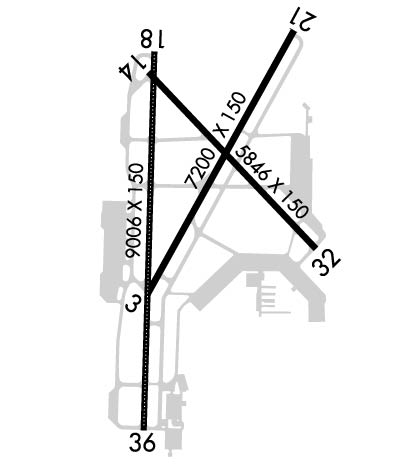
    Length: 7200 ft
    Width: 150 ft
    Surface: CONCRETE-GOOD CONDITION
    Edge lights: High Intensity

    Treatment: GROOVED
    Weight: PCN 95 /R/B/W/T

     Runway: 03   Runway: 21
    Mag heading: 32°Mag heading: 212°
    Rwy Slope: .36% UpRwy Slope: -.36% Down
    Approach: Approach: ILS/DME
    Pattern: Left TrafficPattern: Left Traffic
    Markings: PRECISION INSTRUMENTMarkings: PRECISION INSTRUMENT
    Marking Condition: GOODMarking Condition: GOOD
    Arresting Dev: Arresting Dev: BAK-14; BAK-14 BAK-12(B) (1620').
    Lat & Long: N4308.0  W08920.5Lat. & Long.: N4309.0  W08919.7
    Elev: 860.8 ft. MSLElev: 886.6 ft. MSL
    TCH: 49 ft. AGLTCH: 53 ft. AGL
    Visual Glide Path: 3.00 degreesVisual Glide Path: 3.00 degrees
    Displaced Threshold: 431 feetDisplaced Threshold: No
    Touchdown Zone: YESTouchdown Zone: YES
    Touchdown Elev.: 859.7 feetTouchdown Elev.: 886.6 feet
    Visual Glide Slope: 4-Light PAPI on LEFT side of RunwayVisual Glide Slope: 4-Light PAPI on LEFT side of Runway
    RVR Equipment: RVR Equipment:
    RVV Equipment: NORVV Equipment: NO
    Approach Lights: Approach Lights: MALSR - 1,400 foot medium intensity approach lighting system with runway alignment indicator lights
    REIL: YESREIL: NO
    Centerline Lights: NOCenterline Lights: NO
    Touchdown lights: NOTouchdown lights: NO
    Runway Category: DRunway Category: Precision Instrument Runway
    Declared Distances: TORA:7200' TODA:7200' ASDA:7200' LDA:6770'Declared Distances: TORA:6770' TODA:6770' ASDA:7015' LDA:7015'
    Obstructions: TREESObstructions: ROAD
    Marked: NOT Marked/LightedMarked: NOT Marked/Lighted
    Clearance slope: 35:1; APCH RATIO 41:1 FM DSPLCD THR.Clearance slope: 50:1
    Obstruction height: 72 feet AGLObstruction height: 19 feet AGL
    Dist. from runway: 2760 feetDist. from runway: 2050 feet
    Centerline offset: 460 left of centerlineCenterline offset:
    Comments: Comments:
    Runway Identification: 14/32
    Length: 5846 ft
    Width: 150 ft
    Surface: CONCRETE-GOOD CONDITION
    Edge lights: High Intensity

    Treatment: GROOVED
    Weight: PCN 95 /R/B/W/T

     Runway: 14   Runway: 32
    Mag heading: 139°Mag heading: 319°
    Rwy Slope: .04% UpRwy Slope: -.04% Down
    Approach: Approach:
    Pattern: Left TrafficPattern: Left Traffic
    Markings: NONPRECISION INSTRUMENTMarkings: NONPRECISION INSTRUMENT
    Marking Condition: GOODMarking Condition: GOOD
    Arresting Dev: Arresting Dev:
    Lat & Long: N4308.9  W08920.5Lat. & Long.: N4308.2  W08919.6
    Elev: 858.9 ft. MSLElev: 861.5 ft. MSL
    TCH: 45 ft. AGLTCH: 56 ft. AGL
    Visual Glide Path: 3.00 degreesVisual Glide Path: 3.00 degrees
    Displaced Threshold: 477 feetDisplaced Threshold: No
    Touchdown Zone: YESTouchdown Zone: YES
    Touchdown Elev.: 860.9 feetTouchdown Elev.: 861.5 feet
    Visual Glide Slope: 4-Light PAPI on LEFT side of RunwayVisual Glide Slope: 4-Light PAPI on LEFT side of Runway
    RVR Equipment: RVR Equipment:
    RVV Equipment: NORVV Equipment: NO
    Approach Lights: Approach Lights:
    REIL: YESREIL: YES
    Centerline Lights: NOCenterline Lights: NO
    Touchdown lights: NOTouchdown lights: NO
    Runway Category: DRunway Category: Runway with a Non-precision Approach having visibility minimums greater than 3/4 mile
    Declared Distances: TORA:5846' TODA:5846' ASDA:5846' LDA:5369'Declared Distances: TORA:5846' TODA:5846' ASDA:5846' LDA:5846'
    Obstructions: Obstructions: TREE
    Marked: Marked: NOT Marked/Lighted
    Clearance slope: 34:1Clearance slope: 34:1
    Obstruction height: Obstruction height: 112 feet AGL
    Dist. from runway: Dist. from runway: 4047 feet
    Centerline offset: Centerline offset: 440 feet right of centerline
    Comments: Comments:
    Runway Identification: 18/36
    Length: 9006 ft
    Width: 150 ft
    Surface: CONCRETE-GOOD CONDITION
    Edge lights: High Intensity

    Treatment: GROOVED
    Weight: PCN 95 /R/B/W/T

     Runway: 18   Runway: 36
    Mag heading: 185°Mag heading:
    Rwy Slope: .02% UpRwy Slope: -.02% Down
    Approach: ILS/DMEApproach: ILS/DME
    Pattern: Left TrafficPattern: Left Traffic
    Markings: PRECISION INSTRUMENTMarkings: PRECISION INSTRUMENT
    Marking Condition: GOODMarking Condition: GOOD
    Arresting Dev: BAK-14; BAK-14 BAK-12(B) (1900').Arresting Dev: BAK-14; BAK-14 BAK-12(B) (1750').
    Lat & Long: N4308.9  W08920.5Lat. & Long.: N4307.5  W08920.5
    Elev: 860.3 ft. MSLElev: 862.0 ft. MSL
    TCH: 57 ft. AGLTCH: 59 ft. AGL
    Visual Glide Path: 3.00 degreesVisual Glide Path: 3.00 degrees
    Displaced Threshold: 400 feetDisplaced Threshold: 1001 feet
    Touchdown Zone: YESTouchdown Zone: YES
    Touchdown Elev.: 863.5 feetTouchdown Elev.: 862.0 feet
    Visual Glide Slope: 4-Light PAPI on LEFT side of Runway; UNUSBL BYD 9 DEGS RIGHT OF CNTRLN.Visual Glide Slope: 4-Light PAPI on LEFT side of Runway
    RVR Equipment: TOUCHDOWN-MIDFIELD-ROLLOUTRVR Equipment: TOUCHDOWN-MIDFIELD-ROLLOUT
    RVV Equipment: NORVV Equipment: NO
    Approach Lights: MALSR - 1,400 foot medium intensity approach lighting system with runway alignment indicator lightsApproach Lights: ALSF2 - standard 2,400 foot high intensity approach lighting system with sequenced flashers, Category II or III; RWY 36 ALSF2 OPRS AS SSALR WHEN TWR CLSD.
    REIL: NOREIL: NO
    Centerline Lights: YESCenterline Lights: YES
    Touchdown lights: NOTouchdown lights: NO
    Runway Category: Precision Instrument RunwayRunway Category: Precision Instrument Runway
    Declared Distances: TORA:9006' TODA:9006' ASDA:9006' LDA:8606'Declared Distances: TORA:9006' TODA:9006' ASDA:9006' LDA:8006'
    Obstructions: HILLObstructions:
    Marked: NOT Marked/LightedMarked:
    Clearance slope: 28:1; APCH RATIO 40:1 FM DSPLCD THR.Clearance slope: 50:1
    Obstruction height: 50 feet AGLObstruction height:
    Dist. from runway: 1634 feetDist. from runway:
    Centerline offset: 689 left of centerlineCenterline offset:
    Comments: Comments:
    C:140/P: