Our purpose is to provide the best possible service in a safe and efficient manner. We have a team that enjoys what we do and are good at it. We are proud to deliver customer service that reflects our culture of safety, our commitment to excellence, and the true spirit of aviation.
Air Freight, Avionics, Charter, Flight Instruction, Aircraft Rental, Aircraft Sales
Wind Indicator
YES - (lighted)
Control Tower
YES
CTAF Frequency
118.400
Unicom Frequency
122.950
Rotating Beacon Color
WG
Segmented Circle
YES
Landing Fee
NO; CTC FBO FOR RATES AND CHARGES. LNDG FEE CHARGED FOR ACFT OVER 6,000 LBS AND HELICOPTERS. OVERNIGHT TIEDOWN FEE AT FBO.
Airport Inspection Data
Airport Inspected
FEDERAL - performed by FAA AIRPORTS FIELD PERSONNEL
Inspection Date
01/29/2024
Airport Services
Type of Fuel Available
Grade 100LL, JET A (freeze point -40C)
Airframe Repair Service
MAJOR
Power Plant Repair Service
MAJOR
Geographic Data
Latitude
N3635.2
Longitude
W12150.6 (ESTIMATED)
Arpt Elevation
256ft (SURVEYED)
Magnetic Variation
15E
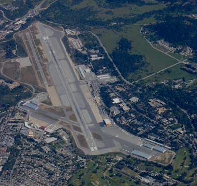
3 miles SE
of MONTEREY
Traffic Pattern Altitude
1500
Sectional Chart
SAN FRANCISCO
Aircraft Data
Operations (Reported)
Yearly
Avg. Daily
General Aviation Transient
25886
71
General Aviation Local
9651
26
Air Taxi
10338
28
Commerical
6586
18
Commuter
0
0
Military
1745
5
Aircraft based on Field
General Aviation Singles
111
General Aviation Multi
8
Jet Aircraft
27
General Aviation Helicopters
0
Military Aircraft
0
Gliders
0
Ultralights
0
FAA Services
FSS on field
NO
FSS tie-in
OAKLAND
FSS Phone
1-800-WX-BRIEF
Who issues Notams
MRY
Notam D service at airport
YES
ARTCC Name
OAKLAND
Federal Status
Airport Certification
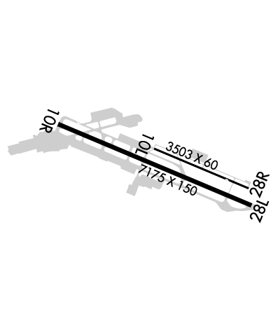
AIRPORT RECEIVING SCHEDULED AIR CARRIER SERVICE FROM CARRIERS CERTIFICATED BY THE CIVIL AERONAUTICS BOARD; RWY 10L/28R NOT AVBL FOR SKED ACR OPNS WITH MORE THAN 9 PSGR SEATS OR UNSKED ACR AT LEAST 31 PSGR SEATS.
Aircraft Rescue & Firefighting Index
AIRPORT HAS A CERTIFICATE UNDER CFR PART 139
Airport of Entry
No
Custom Landing Rights
YES
Joint Civil/Military
No
Military Landing rights
YES
Federal Agreements
NATIONAL PLAN OF INTEGRATED AIRPORT SYSTEMS (NPIAS)
GRANT AGREEMENTS UNDER FAAP/ADAP/AIP
ASSURANCES PURSUANT TO TITLE VI, CIVIL RIGHTS ACT OF 1964
Remarks
ATCT NON-VISIBILITY AREA TAXIWAY ALPHA EAST HOLDING BAY.
ACFT WITH WINGSPAN GREATER THAN 65' PROHIBITED ON TWY BRAVO BETWEEN TWY ECHO AND TWY DELTA.
FACILITY CONSTRAINTS FOR COMMERCIAL DIVERSIONS: ADG III AND LARGER WITH SEATING CAPACITY MORE THEN 150 PAX ARE HIGHLY DISCOURAGED. CBP PROCESSING FACILITIES UNAVAILABLE.
FOR CD OR CNL IFR WHEN ATCT CLSD, CTC NORCAL APP CON ON 133.5; IF UNA, CTC NORCAL APCH AT 916-361-3748.
FIRE STN APN CLSD TO HEL TFC.
AVOID FLYING RWY 28L RNAV Y WHEN POSS TO RDC NOISE IMPACTS.
RWY 28L RNAV AND RNP APCHS ARE NOT TO BE USED FOR PRACTICE APCHS.
RWY 10L/28R NOT AVBL FOR ACR USE.
ROTARY WING ACFT EXPECT TO FOLLOW FIXED WING PAT TO RWY LNDG.
LTD TRANSIENT PARKING PPR REQUIRED FOR LARGE AND TURBINE POWERED MULT ENG ACFT; (831) 648-7000 OPTION 2.
ON DEP NO TURNS BLO 900 FT UNLESS ATC DIRECTED.
NOISE ABATEMENT PROCEDURES IN EFFECT 2300-0700.
PLEASE AVOID FLTS OVR RESIDENTIAL AREAS, N AND S. CTC ARPT OPNS 831-648-7000 OPTION 2 OR WWW.MONTEREYAIRPORT.COM FOR PROCS.
ACFT WITH WINGSPAN GREATER THAN 95 FT MAY NOT TAXI PAST THE TERMINAL ON TWY ALPHA WHEN AN MD-80 OR 757 IS PARKED AT TERMINAL.
Airport Communications & Frequencies:
ATIS Frequencies: Hours(local) of Operation: CONTINUOUS
119.25
MONTEREY Tower Frequencies: Hours(local) of operation: 0600-2100
118.4
257.8
MONTEREY Ground Frequencies:
120.875
348.6
Clearance Delivery Frequencies:
135.45
Emergency Frequencies:
121.5
243.0
CTAF Frequency:
118.400
Unicom Frequency:
122.950
Remarks
STAGE-III SVC NOT AVBL WITHIN SALINAS ATA.
ASR-11 ANTENNA LOCATED MARINA MUNI (OAR), REMOTED TO MONTEREY RGNL (MRY). ASR-11 SERVES MRY AND OAR.