Current Weather/Notams (Metars, TAFs, Notams, NWS Forecast, PIREPS, and nearby weather)
Customs Information Send updates to Support@FltPlan.com
Customs Not Available
Database effective 05/16/2024
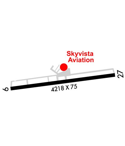
Airport Diagram might not be current. Facility Name: UNION COUNTY City Name: MARYSVILLE County: UNION State abbrev: OH State Name: OHIO Ownership: PUBLICLY OWNED Use: OPEN TO THE PUBLIC Owner's Name: UNION COUNTY ARPT AUTH Address: COUNTY COURTHOUSE, 215 W 5TH ST MARYSVILLE, OH 43040 Owner's Phone: 937-644-2055 Manager's Name: DAVID HOLDEN; SKYVISTAAVIATION@GMAIL.COM. Address: 760 CLYMER RD MARYSVILLE, OH 43040-9502 Phone: 937-644-2055; AFT HRS & EMERG 937-741-3120. FAA Region: GREAT LAKES FAA Field Office: DET
Runway Identifications Help
Runway Identification: 08/26 Length: 2702 ftWidth: 81 ftSurface: GRASS-GOOD CONDITIONEdge lights: Treatment: NONE Runway: 08 Runway: 26 Mag heading: 88° Mag heading: 268° Rwy Slope: -.79% Down Rwy Slope: .79% Up Approach: Approach: Pattern: Left Traffic Pattern: Left Traffic Markings: Markings: Marking Condition: THR & EDGES MKD WITH CONES. Marking Condition: THR & EDGES MKD WITH CONES. Arresting Dev: Arresting Dev: Lat & Long: N4013.4 W08321.4 Lat. & Long.: N4013.5 W08320.8 Elev: 1015.2 ft. MSL Elev: 993.9 ft. MSL TCH: TCH: Visual Glide Path: Visual Glide Path: Displaced Threshold: No Displaced Threshold: No Touchdown Zone: YES Touchdown Zone: YES Touchdown Elev.: 1015.2 feet Touchdown Elev.: 1015.2 feet Visual Glide Slope: Visual Glide Slope: RVR Equipment: RVR Equipment: RVV Equipment: NO RVV Equipment: NO Approach Lights: Approach Lights: REIL: NO REIL: NO Centerline Lights: NO Centerline Lights: NO Touchdown lights: NO Touchdown lights: NO Runway Category: Runway with a Visual Approach Runway Category: Runway with a Visual Approach Declared Distances: Declared Distances:
Runway Identification: 09/27 Length: 4218 ftWidth: 75 ftSurface: ASPHALT-FAIR CONDITIONEdge lights: Medium Intensity Treatment: NONE Runway: 09 Runway: 27 Mag heading: 88° Mag heading: 268° Rwy Slope: -.56% Down Rwy Slope: .56% Up Approach: Approach: Pattern: Left Traffic Pattern: Left Traffic; CK NOTAMS FOR STS OF AEROBATIC BOX SOUTH OF RWY 09/27 & 08/26 - RP RWY 27 & 26 WHEN ACTV. Markings: NONPRECISION INSTRUMENT Markings: NONPRECISION INSTRUMENT Marking Condition: GOOD Marking Condition: GOOD Arresting Dev: Arresting Dev: Lat & Long: N4013.4 W08321.5 Lat. & Long.: N4013.5 W08320.6 Elev: 1020.6 ft. MSL Elev: 996.8 ft. MSL TCH: 25 ft. AGL TCH: 33 ft. AGL Visual Glide Path: 3.00 degrees Visual Glide Path: 3.00 degrees Displaced Threshold: No Displaced Threshold: 123 feet Touchdown Zone: YES Touchdown Zone: YES Touchdown Elev.: 1020.7 feet Touchdown Elev.: 1015.1 feet Visual Glide Slope: 4-Light PAPI on LEFT side of Runway Visual Glide Slope: 4-Light PAPI on LEFT side of Runway RVR Equipment: RVR Equipment: RVV Equipment: NO RVV Equipment: NO Approach Lights: Approach Lights: REIL: YES REIL: YES Centerline Lights: NO Centerline Lights: NO Touchdown lights: NO Touchdown lights: NO Runway Category: Runway with a Non-precision Approach Runway Category: Runway with a Non-precision Approach Declared Distances: Declared Distances: Obstructions: Obstructions: RR Marked: Marked: NOT Marked/Lighted Clearance slope: 20:1 Clearance slope: 11:1; APCH RATIO 27:1 TO DTHR DUE TO +20 FT RR, 425 FT DIST, 260 FT R. Obstruction height: Obstruction height: 20 feet AGL Dist. from runway: Dist. from runway: 425 feet Centerline offset: Centerline offset: 260 feet right of centerline Comments: Comments: