Current Weather/Notams (Metars, TAFs, Notams, NWS Forecast, PIREPS, and nearby weather)
Customs Information Send updates to Support@FltPlan.com
Customs Not Available
Database effective 04/18/2024
Airport Diagram might not be current.
|
| Facility Name: | IOWA COUNTY |
| City Name: | MINERAL POINT |
| County: | IOWA |
| State abbrev: | WI |
| State Name: | WISCONSIN |
| | |
| Ownership: | PUBLICLY OWNED |
| Use: | OPEN TO THE PUBLIC |
| Owner's Name: | IOWA COUNTY |
| Address: | 222 N. IOWA STREET |
| | DODGEVILLE, WI 53533 |
| Owner's Phone: | 608-987-9931 |
| | |
| Manager's Name: | REESE MEYER |
| Address: | 3151 STATE RD 39 |
| | MINERAL POINT, WI 53565 |
| Phone: | 608-553-7571 |
| | |
| FAA Region: | GREAT LAKES |
| FAA Field Office: | CHI |
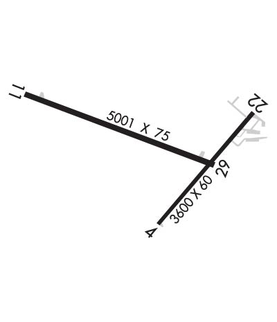
Runway Identifications
Runway Identification: 04/22Length: 3600 ft
Width: 60 ft
Surface: ASPHALT-GOOD CONDITION
Edge lights: Medium IntensityTreatment: NONE
| | Runway: 04 | | Runway: 22 |
| Mag heading: | 40° | Mag heading: | 220° |
| Rwy Slope: | .19% Up | Rwy Slope: | -.19% Down |
| Approach: | | Approach: | |
| Pattern: | Left Traffic | Pattern: | Left Traffic |
| Markings: | NONPRECISION INSTRUMENT | Markings: | NONPRECISION INSTRUMENT |
| Marking Condition: | GOOD | Marking Condition: | GOOD |
| Arresting Dev: | | Arresting Dev: | |
| Lat & Long: | N4252.9 W09014.2 | Lat. & Long.: | N4253.3 W09013.7 |
| Elev: | 1163.7 ft. MSL | Elev: | 1170.6 ft. MSL |
| TCH: | 31 ft. AGL | TCH: | 30 ft. AGL |
| Visual Glide Path: | 3.00 degrees | Visual Glide Path: | 3.00 degrees |
| Displaced Threshold: | No | Displaced Threshold: | No |
| Touchdown Zone: | YES | Touchdown Zone: | YES |
| Touchdown Elev.: | 1168.0 feet | Touchdown Elev.: | 1170.7 feet |
| Visual Glide Slope: | 2-Light PAPI on LEFT side of Runway; VGSI AND RNAV GLIDEPATH NOT COINCIDENT. | Visual Glide Slope: | 2-Light PAPI on LEFT side of Runway; VGSI AND RNAV GLIDEPATH NOT COINCIDENT. |
| RVR Equipment: | | RVR Equipment: | |
| RVV Equipment: | NO | RVV Equipment: | NO |
| Approach Lights: | | Approach Lights: | |
| REIL: | NO | REIL: | NO |
| Centerline Lights: | NO | Centerline Lights: | NO |
| Touchdown lights: | NO | Touchdown lights: | NO |
| Runway Category: | Runway with a Non-precision Approach | Runway Category: | Runway with a Non-precision Approach |
| Declared Distances: | | Declared Distances: | |
Runway Identification: 11/29Length: 5001 ft
Width: 75 ft
Surface: ASPHALT-FAIR CONDITION
Edge lights: Medium IntensityTreatment: NONE
| | Runway: 11 | | Runway: 29 |
| Mag heading: | 111° | Mag heading: | 291° |
| Rwy Slope: | .70% Up | Rwy Slope: | -.70% Down |
| Approach: | | Approach: | |
| Pattern: | Left Traffic | Pattern: | Left Traffic |
| Markings: | NONPRECISION INSTRUMENT | Markings: | NONPRECISION INSTRUMENT |
| Marking Condition: | FAIR | Marking Condition: | GOOD |
| Arresting Dev: | | Arresting Dev: | |
| Lat & Long: | N4253.4 W09014.9 | Lat. & Long.: | N4253.1 W09013.9 |
| Elev: | 1129.1 ft. MSL | Elev: | 1163.9 ft. MSL |
| TCH: | 43 ft. AGL | TCH: | 44 ft. AGL |
| Visual Glide Path: | 3.00 degrees | Visual Glide Path: | 3.00 degrees |
| Displaced Threshold: | No | Displaced Threshold: | No |
| Touchdown Zone: | YES | Touchdown Zone: | YES |
| Touchdown Elev.: | 1152.4 feet | Touchdown Elev.: | 1163.9 feet |
| Visual Glide Slope: | 2-Light PAPI on LEFT side of Runway | Visual Glide Slope: | 2-Light PAPI on LEFT side of Runway |
| RVR Equipment: | | RVR Equipment: | |
| RVV Equipment: | NO | RVV Equipment: | NO |
| Approach Lights: | | Approach Lights: | |
| REIL: | YES | REIL: | YES |
| Centerline Lights: | NO | Centerline Lights: | NO |
| Touchdown lights: | NO | Touchdown lights: | NO |
| Runway Category: | D | Runway Category: | Runway with a Non-precision Approach having visibility minimums greater than 3/4 mile |
| Declared Distances: | | Declared Distances: | |
| Obstructions: | TREES | Obstructions: | |
| Marked: | NOT Marked/Lighted | Marked: | |
| Clearance slope: | 23:1 | Clearance slope: | 34:1 |
| Obstruction height: | 16 feet AGL | Obstruction height: | |
| Dist. from runway: | 570 feet | Dist. from runway: | |
| Centerline offset: | 525 left of centerline | Centerline offset: | |
| Comments: | | Comments: | |

