Current Weather/Notams (Metars, TAFs, Notams, NWS Forecast, PIREPS, and nearby weather)
Customs Information Send updates to Support@FltPlan.com
Customs Not Available
Database effective 05/16/2024
Airport Diagram might not be current.
|
| Facility Name: | MAURY COUNTY RGNL |
| City Name: | COLUMBIA/MOUNT PLEASANT |
| County: | MAURY |
| State abbrev: | TN |
| State Name: | TENNESSEE |
| | |
| Ownership: | PUBLICLY OWNED |
| Use: | OPEN TO THE PUBLIC |
| Owner's Name: | MAURY CO REG ARPT AUTH |
| Address: | 1200 N MAIN ST |
| | MT PLEASANT, TN 38474 |
| Owner's Phone: | 931-379-5511 |
| | |
| Manager's Name: | PAUL TURNER |
| Address: | 1200 NORTH MAIN ST |
| | MT PLEASANT, TN 38474 |
| Phone: | 931-379-5511 |
| | |
| FAA Region: | SOUTHERN |
| FAA Field Office: | MEM |
Runway Identifications
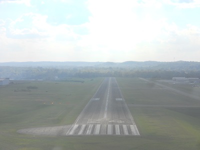
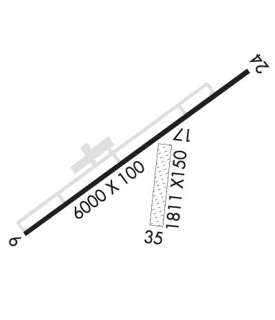
Runway Identification: 06/24Length: 6000 ft
Width: 100 ft
Surface: ASPHALT-GOOD CONDITION
Edge lights: Medium IntensityTreatment: NONE
Weight: PCN 12 /F/C/X/T
| | Runway: 06 | | Runway: 24 |
| Mag heading: | 55° | Mag heading: | 235° |
| Rwy Slope: | .29% Up | Rwy Slope: | -.29% Down |
| Approach: | | Approach: | SDF |
| Pattern: | Left Traffic | Pattern: | Left Traffic |
| Markings: | NONPRECISION INSTRUMENT | Markings: | NONPRECISION INSTRUMENT |
| Marking Condition: | FAIR | Marking Condition: | FAIR |
| Arresting Dev: | | Arresting Dev: | |
| Lat & Long: | N3533.0 W08711.2 | Lat. & Long.: | N3533.6 W08710.3 |
| Elev: | 664.0 ft. MSL | Elev: | 681.1 ft. MSL |
| TCH: | 42 ft. AGL | TCH: | 42 ft. AGL |
| Visual Glide Path: | 3.00 degrees | Visual Glide Path: | 3.00 degrees |
| Displaced Threshold: | No | Displaced Threshold: | No |
| Touchdown Zone: | YES | Touchdown Zone: | YES |
| Touchdown Elev.: | 670.5 feet | Touchdown Elev.: | 681.3 feet |
| Visual Glide Slope: | 4-Light PAPI on RIGHT side of Runway | Visual Glide Slope: | 4-Light PAPI on LEFT side of Runway |
| RVR Equipment: | | RVR Equipment: | |
| RVV Equipment: | NO | RVV Equipment: | NO |
| Approach Lights: | | Approach Lights: | ODALS - omnidirectional approach lighting system |
| REIL: | YES | REIL: | YES |
| Centerline Lights: | NO | Centerline Lights: | NO |
| Touchdown lights: | NO | Touchdown lights: | NO |
| Runway Category: | Runway with a Non-precision Approach having visibility minimums greater than 3/4 mile | Runway Category: | D |
| Declared Distances: | TORA:6000' TODA:6000' ASDA:6000' LDA:6000' | Declared Distances: | TORA:6000' TODA:6000' ASDA:6000' LDA:6000' |
| Obstructions: | TREE | Obstructions: | TREE |
| Marked: | NOT Marked/Lighted | Marked: | NOT Marked/Lighted |
| Clearance slope: | 22:1 | Clearance slope: | 23:1 |
| Obstruction height: | 61 feet AGL | Obstruction height: | 45 feet AGL |
| Dist. from runway: | 1573 feet | Dist. from runway: | 1273 feet |
| Centerline offset: | 76 left of centerline | Centerline offset: | 350 feet left of centerline |
| Comments: | | Comments: | |
Runway Identification: 17/35Length: 1941 ft
Width: 95 ft
Surface: GRASS-GOOD CONDITION
Edge lights: Treatment: NONE
| | Runway: 17 | | Runway: 35 |
| Mag heading: | 188° | Mag heading: | 8° |
| Rwy Slope: | -.39% Down | Rwy Slope: | .39% Up |
| Approach: | | Approach: | |
| Pattern: | Left Traffic | Pattern: | Left Traffic |
| Markings: | | Markings: | |
| Marking Condition: | | Marking Condition: | |
| Arresting Dev: | | Arresting Dev: | |
| Lat & Long: | N3533.3 W08710.7 | Lat. & Long.: | N3532.9 W08710.8 |
| Elev: | 666.7 ft. MSL | Elev: | 659.2 ft. MSL |
| TCH: | | TCH: | |
| Visual Glide Path: | | Visual Glide Path: | |
| Displaced Threshold: | No | Displaced Threshold: | No |
| Touchdown Zone: | YES | Touchdown Zone: | YES |
| Touchdown Elev.: | 666.7 feet | Touchdown Elev.: | 659.2 feet |
| Visual Glide Slope: | | Visual Glide Slope: | |
| RVR Equipment: | | RVR Equipment: | |
| RVV Equipment: | NO | RVV Equipment: | NO |
| Approach Lights: | | Approach Lights: | |
| REIL: | NO | REIL: | NO |
| Centerline Lights: | NO | Centerline Lights: | NO |
| Touchdown lights: | NO | Touchdown lights: | NO |
| Runway Category: | Runway with a Visual Approach | Runway Category: | Runway with a Visual Approach |
| Declared Distances: | | Declared Distances: | |
| Obstructions: | POLE | Obstructions: | |
| Marked: | NOT Marked/Lighted | Marked: | |
| Clearance slope: | 17:1 | Clearance slope: | 20:1 |
| Obstruction height: | 81 feet AGL | Obstruction height: | |
| Dist. from runway: | 1379 feet | Dist. from runway: | |
| Centerline offset: | 194 right of centerline | Centerline offset: | |
| Comments: | | Comments: | |