Current Weather/Notams (Metars, TAFs, Notams, NWS Forecast, PIREPS, and nearby weather)
Customs Information Send updates to Support@FltPlan.com
Customs Not Available
Database effective 05/16/2024
Airport Diagram might not be current.
|
| Facility Name: | TELFAIR-WHEELER |
| City Name: | MC RAE |
| County: | WHEELER |
| State abbrev: | GA |
| State Name: | GEORGIA |
| | |
| Ownership: | PUBLICLY OWNED |
| Use: | OPEN TO THE PUBLIC |
| Owner's Name: | TELFAIR-WHEELER AIRPORT AUTH |
| Address: | P.O. BOX 192 |
| | MC RAE, GA 30411 |
| Owner's Phone: | 229-315-1227 |
| | |
| Manager's Name: | JIMMY RAY |
| Address: | P.O. BOX 192 |
| | MCRAE, GA 31055 |
| Phone: | 229-315-1227 |
| | |
| FAA Region: | SOUTHERN |
| FAA Field Office: | ATL |
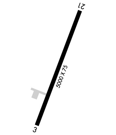
Runway Identifications
Runway Identification: 03/21Length: 5001 ft
Width: 75 ft
Surface: ASPHALT-FAIR CONDITION
Edge lights: Medium IntensityTreatment: NONE
| | Runway: 03 | | Runway: 21 |
| Mag heading: | 26° | Mag heading: | 206° |
| Rwy Slope: | -.19% Down | Rwy Slope: | .19% Up |
| Approach: | | Approach: | |
| Pattern: | Left Traffic | Pattern: | Left Traffic |
| Markings: | NONPRECISION INSTRUMENT | Markings: | NONPRECISION INSTRUMENT |
| Marking Condition: | GOOD | Marking Condition: | GOOD |
| Arresting Dev: | | Arresting Dev: | |
| Lat & Long: | N3205.4 W08253.0 | Lat. & Long.: | N3206.2 W08252.6 |
| Elev: | 201.9 ft. MSL | Elev: | 192.6 ft. MSL |
| TCH: | 44 ft. AGL | TCH: | 36 ft. AGL |
| Visual Glide Path: | 3.00 degrees | Visual Glide Path: | 3.00 degrees |
| Displaced Threshold: | No | Displaced Threshold: | No |
| Touchdown Zone: | YES | Touchdown Zone: | YES |
| Touchdown Elev.: | 202.1 feet | Touchdown Elev.: | 200.7 feet |
| Visual Glide Slope: | 2-Light PAPI on LEFT side of Runway | Visual Glide Slope: | 2-Light PAPI on LEFT side of Runway |
| RVR Equipment: | | RVR Equipment: | |
| RVV Equipment: | NO | RVV Equipment: | NO |
| Approach Lights: | | Approach Lights: | |
| REIL: | NO | REIL: | YES |
| Centerline Lights: | NO | Centerline Lights: | NO |
| Touchdown lights: | NO | Touchdown lights: | NO |
| Runway Category: | Runway with a Non-precision Approach having visibility minimums greater than 3/4 mile | Runway Category: | Runway with a Non-precision Approach having visibility minimums greater than 3/4 mile |
| Declared Distances: | | Declared Distances: | |
| Obstructions: | TREES | Obstructions: | TREES |
| Marked: | NOT Marked/Lighted | Marked: | NOT Marked/Lighted |
| Clearance slope: | 9:1 | Clearance slope: | 11:1 |
| Obstruction height: | 53 feet AGL | Obstruction height: | 66 feet AGL |
| Dist. from runway: | 677 feet | Dist. from runway: | 926 feet |
| Centerline offset: | 307 left of centerline | Centerline offset: | 310 feet left of centerline |
| Comments: | | Comments: | |

