
| ||||||||||||||||||||||||||||||||||||||||||||
| ||||||||||||||||||||||||||||||||||||||||||||
| ||||||||||||||||||||||||||||||||||||||||||||
| ||||||||||||||||||||||||||||||||||||||||||||
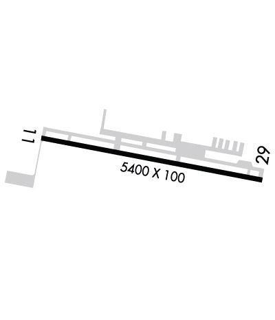
| Rwy | Rwy | |||||||
| 5400x100 | 5400' | 5400x100 | 5400' | 108.50 - 293° | ||||
| Runway ID | Single Wheel | Double Wheel | Double Tandem Wheel | Dual Double Wheel |
| 11/29 | 30,000 | 48,000 | N/A | N/A |
| These numbers are Advisory and are not limits. The Airport Manager should have more accurate Weight Limits | ||||
 Airport Diagram might not be current. | |
| Facility Name: | CHESTER COUNTY G O CARLSON |
| City Name: | COATESVILLE |
| County: | CHESTER |
| State abbrev: | PA |
| State Name: | PENNSYLVANIA |
| Ownership: | PUBLICLY OWNED |
| Use: | OPEN TO THE PUBLIC |
| Owner's Name: | CHESTER CO ARPT AUTH |
| Address: | 1 EARHART DR SUITE 2 |
| COATESVILLE, PA 19320 | |
| Owner's Phone: | 610-383-6057 |
| Manager's Name: | GARY L HUDSON |
| Address: | 1 EARHART DR SUITE 2 |
| COATESVILLE, PA 19320 | |
| Phone: | 610-383-6057; CELL 484-880-2959 |
| FAA Region: | EASTERN |
| FAA Field Office: | HAR |
| Date | Sunrise | Sunset |
|---|---|---|
| 04/22/24 Monday | 6:14 | 19:50 |
| 04/23/24 Tuesday | 6:13 | 19:51 |
| 04/24/24 Wednesday | 6:12 | 19:52 |
| 04/25/24 Thursday | 6:10 | 19:53 |
| 04/26/24 Friday | 6:09 | 19:54 |
| 04/27/24 Saturday | 6:08 | 19:55 |
| 04/28/24 Sunday | 6:06 | 19:56 |
| 04/29/24 Monday | 6:05 | 19:57 |
| 04/30/24 Tuesday | 6:04 | 19:58 |
| 05/01/24 Wednesday | 6:03 | 19:59 |
| 05/02/24 Thursday | 6:01 | 20:00 |
| 05/03/24 Friday | 6:00 | 20:01 |
| 05/04/24 Saturday | 5:59 | 20:02 |
| 05/05/24 Sunday | 5:58 | 20:03 |
| Airport Attendance Schedule | 7 Days A Week 0600-2200; FOR SVC AFTER HRS CNT 610-384-9000 |
| Airport Status | OPERATIONAL (This Status can change at any time - please check NOTAMS) |
| Airport Lighting Schedule | DUSK-DAWN. ACTVT REIL RWY 11/29; VASI RWY 11; HIRL RWY 11/29 - CTAF. |
| Airport Storage Available | Tie Downs, Hanger |
| Extra Services Available | Avionics, Flight Instruction, Aircraft Rental, Aircraft Sales |
| Wind Indicator | YES - (lighted) |
| Control Tower | NO |
| CTAF Frequency | 122.700 |
| Unicom Frequency | 122.700 |
| Rotating Beacon Color | WG |
| Segmented Circle | NO |
| Landing Fee | NO |
| Airport Inspected | STATE - performed by STATE AERONAUTICAL PERSONNEL |
| Inspection Date | 12/07/2023 |
| Type of Fuel Available | Grade 100LL, JET A (freeze point -40C) |
| Airframe Repair Service | MAJOR |
| Power Plant Repair Service | MAJOR |
| Latitude | N3958.7 |
| Longitude | W07551.9 (ESTIMATED) |
| Arpt Elevation | 660ft (SURVEYED) |
| Magnetic Variation | 11W |
| 2 miles W | of COATESVILLE |
| Traffic Pattern Altitude | |
| Sectional Chart | WASHINGTON |
| Operations (Reported) | Yearly | Avg. Daily |
|---|---|---|
| General Aviation Transient | 23760 | 65 |
| General Aviation Local | 16100 | 44 |
| Air Taxi | 2590 | 7 |
| Commerical | 0 | 0 |
| Commuter | 0 | 0 |
| Military | 50 | 0 |
| Aircraft based on Field | |
|---|---|
| General Aviation Singles | 59 |
| General Aviation Multi | 10 |
| Jet Aircraft | 14 |
| General Aviation Helicopters | 1 |
| Military Aircraft | 0 |
| Gliders | 0 |
| Ultralights | 0 |
| FSS on field | NO |
| FSS tie-in | WILLIAMSPORT |
| FSS Phone | 1-800-WX-BRIEF |
| Who issues Notams | IPT |
| Notam D service at airport | YES |
| ARTCC Name | NEW YORK |
| Airport Certification | |
| Aircraft Rescue & Firefighting Index | None |
| Airport of Entry | No |
| Custom Landing Rights | No |
| Joint Civil/Military | No |
| Military Landing rights | YES |
| NATIONAL PLAN OF INTEGRATED AIRPORT SYSTEMS (NPIAS) |
| GRANT AGREEMENTS UNDER FAAP/ADAP/AIP |
| ASSURANCES PURSUANT TO TITLE VI, CIVIL RIGHTS ACT OF 1964 |
| MIGRATORY BIRDS & DEER ON & INVOF ARPT. |
| FOR CD CTC PHILADELPHIA APCH AT 800-354-9884. |
| NOISE ABATEMENT PROCEDURES IN EFFECT, CTC FBO 610-384-9000. |
| +164 FT WATER TWR 1343 FT FM RY 11 THR 1842 FT R MKD WITH STROBE LGT DALGT HRS; STD OBSTN LGT NGT HRS. |
| HELICOPTER OPS INVOF ARPT SOUTH AND SOUTHWEST OF RY 11 THLD. |
| HELICOPTER TRAFFIC REQUESTED TO LAND AND TKOF FM RY ONLY. HELICOPTER HOVER TAXIING, TKOFS, & LNDGS PROHIBITED FM TWY ALPHA. |
| HOVER TAXI ALONG TXY ALPHA PROHIBITED. WHEEL TAXI ON TXY OR HOVER FM RY TO RAMP SIDE PARKING SPOT BY CROSSING PERPENDICULAR TO ALPHA. |
Airport Communications & Frequencies:
| ||||||||||||||||
| Runway: 11 | Runway: 29 | ||
| Mag heading: | 113° | Mag heading: | 293° |
| Rwy Slope: | .40% Up | Rwy Slope: | -.40% Down |
| Approach: | Approach: | ILS | |
| Pattern: | Left Traffic | Pattern: | Left Traffic |
| Markings: | NONPRECISION INSTRUMENT | Markings: | PRECISION INSTRUMENT |
| Marking Condition: | GOOD | Marking Condition: | GOOD |
| Arresting Dev: | Arresting Dev: | ||
| Lat & Long: | N3958.8 W07552.5 | Lat. & Long.: | N3958.6 W07551.4 |
| Elev: | 638.4 ft. MSL | Elev: | 660.0 ft. MSL |
| TCH: | 52 ft. AGL | TCH: | 57 ft. AGL |
| Visual Glide Path: | 3.00 degrees | Visual Glide Path: | 3.00 degrees |
| Displaced Threshold: | No | Displaced Threshold: | No |
| Touchdown Zone: | YES | Touchdown Zone: | YES |
| Touchdown Elev.: | 643.9 feet | Touchdown Elev.: | 660.2 feet |
| Visual Glide Slope: | 4-BOX VASI ON RIGHT SIDE OF RUNWAY | Visual Glide Slope: | 4-Light PAPI on LEFT side of Runway |
| RVR Equipment: | RVR Equipment: | ||
| RVV Equipment: | NO | RVV Equipment: | NO |
| Approach Lights: | Approach Lights: | ||
| REIL: | YES | REIL: | YES |
| Centerline Lights: | NO | Centerline Lights: | NO |
| Touchdown lights: | NO | Touchdown lights: | NO |
| Runway Category: | Runway with a Non-precision Approach having visibility minimums greater than 3/4 mile | Runway Category: | Precision Instrument Runway |
| Declared Distances: | Declared Distances: | ||
| Obstructions: | TREE | Obstructions: | TREES |
| Marked: | LIGHTED | Marked: | NOT Marked/Lighted |
| Clearance slope: | 10:1 | Clearance slope: | 4:1 |
| Obstruction height: | 54 feet AGL | Obstruction height: | 9 feet AGL |
| Dist. from runway: | 777 feet | Dist. from runway: | 238 feet |
| Centerline offset: | 504 left of centerline | Centerline offset: | 467 feet left of centerline |
| Comments: | Comments: |