Click here for more info on on SMS!

KMQI

MANTEO
NC
Time Zone: Eastern
Lat: N 3555.1
Long: W 07541.7
Elev: 13
Var: +09
Longest Runway: 4306
AWOS: 128.27
CTAF: 122.8

FBO & Flight Services info for KMQI

FBOs: Update your Fuel Prices

DARE COUNTYPh: 252-475-5575
-
Freq: 122.8
Service
Jet
100LL
SAF
MoGas
Full5.706.00    Last Update: 04/14/2024 13:11

Self  5.70    
 Address: 410 AIRPORT RD   MANTEO, NC 27955
If you are an FBO, call 1-203-262-1700 to update your info or email: FltPlan.Advertising@garmin.com
Advertise your FBO on FltPlan.com

Runway & Approach Info for KMQI
Rwy
Length
Land Dist**
Approach*
  Rwy
Length
Land Dist**
Approach*
05
4306x100  4001'          
 
  
23
  4306x100  4005'          
 
17
3303x75  3013'          
 
  
35
  3303x75  2314'          
 
 * only ILS, LOC, LDA, and SDF approaches to a specific runway are shown
** For any Declared Landing Distance Available, please see A/FD or Approach plates
Runway Weight Capability (lbs.) Help
Runway IDSingle WheelDouble WheelDouble Tandem WheelDual Double Wheel
05/2348,000N/AN/AN/A
17/3520,000N/AN/AN/A
These numbers are Advisory and are not limits.   The Airport Manager should have more accurate Weight Limits
Approach Charts
Approaches    
Current Weather/Notams
Customs Information Send updates to Support@FltPlan.com
Customs Not Available
Database effective 04/18/2024
Airport Diagram of KMQI
Airport Diagram might not be current.

Facility Name: DARE COUNTY RGNL
City Name: MANTEO
County: DARE
State abbrev: NC
State Name: NORTH CAROLINA
   
Ownership: PUBLICLY OWNED
Use: OPEN TO THE PUBLIC
Owner's Name: DARE COUNTY
Address: PO BOX 429
 MANTEO, NC 27954
Owner's Phone: 252-475-5570
  
Manager's Name: STACY AMBROSE
Address: 410 AIRPORT ROAD
 MANTEO, NC 27954-9110
Phone: 252-475-5571
   
FAA Region: SOUTHERN
FAA Field Office: MEM


Sunrise / Sunset times for DARE COUNTY RGNL

DateSunriseSunset
04/18/24 Thursday6:2519:40
04/19/24 Friday6:2419:40
04/20/24 Saturday6:2219:41
04/21/24 Sunday6:2119:42
04/22/24 Monday6:2019:43
04/23/24 Tuesday6:1919:44
04/24/24 Wednesday6:1819:45
04/25/24 Thursday6:1619:45
04/26/24 Friday6:1519:46
04/27/24 Saturday6:1419:47
04/28/24 Sunday6:1319:48
04/29/24 Monday6:1219:49
04/30/24 Tuesday6:1119:50
05/01/24 Wednesday6:1019:51

Airport Facilities

Airport Attendance Schedule7 Days A Week 0800-1900; UNATTNDD CHRISTMAS DAY. FOR SVC AFT HRS CALL 252-216-7028 OR 252-216-8407.
Airport Status OPERATIONAL (This Status can change at any time - please check NOTAMS)
Airport Lighting ScheduleACTVT REIL RWY 05; MIRL RWY 05/23 & 17/35 - CTAF. PAPI RWY 05 & 23 OPR CONSLY.
Airport Storage AvailableTie Downs, Hanger
Extra Services AvailableAir Freight, Air Ambulance, Charter, Flight Instruction, Parachute Jumping, Aircraft Rental
Wind IndicatorYES - (lighted)
Control TowerNO
CTAF Frequency122.800
Unicom Frequency122.800
Rotating Beacon ColorWG
Segmented CircleYES
Landing FeeNO

Airport Inspection Data

Airport InspectedSTATE - performed by STATE AERONAUTICAL PERSONNEL
Inspection Date07/08/2023

Airport Services

Type of Fuel AvailableGrade 100LL, JET A-1 (icing inhibitor, freeze point -50C); -10100LL AVBL AFT HRS SELF SVC WITH CREDIT CARD.
Airframe Repair ServiceMAJOR
Power Plant Repair ServiceMAJOR

Geographic Data

LatitudeN3555.1
LongitudeW07541.7 (ESTIMATED)
Arpt Elevation12ft (SURVEYED)
Magnetic Variation09W
1 miles NWof MANTEO
Traffic Pattern Altitude
Sectional ChartCHARLOTTE

Aircraft Data

Operations (Reported)YearlyAvg. Daily
General Aviation Transient 440012
General Aviation Local 23006
Air Taxi 1005028
Commerical 00
Commuter 00
Military 2001
Aircraft based on Field
General Aviation Singles 42
General Aviation Multi 1
Jet Aircraft 0
General Aviation Helicopters 2
Military Aircraft 0
Gliders 0
Ultralights 0

FAA Services

FSS on field NO
FSS tie-in RALEIGH
FSS Phone 1-800-WX-BRIEF
Who issues Notams MQI
Notam D service at airport YES
ARTCC Name WASHINGTON

Federal Status

Airport Certification
Aircraft Rescue & Firefighting IndexNone
Airport of EntryNo
Custom Landing RightsNo
Joint Civil/MilitaryNo
Military Landing rightsYES

Federal Agreements

NATIONAL PLAN OF INTEGRATED AIRPORT SYSTEMS (NPIAS)
GRANT AGREEMENTS UNDER FAAP/ADAP/AIP
SURPLUS PROPERTY AGREEMENT UNDER PUBLIC LAW 289
SURPLUS PROPERTY AGREEMENT UNDER REGULATION 16-WAA
ASSURANCES PURSUANT TO TITLE VI, CIVIL RIGHTS ACT OF 1964
AGREEMENT UNDER DLAND OR DCLA HAS EXPIRED.

Remarks

RWY 05 15 FT DROP-OFF 40 FT FM THR 0B.
TWY F CLSD PERMLY.
FOR CD CTC CHERRY POINT APCH AT 252-466-5960, OR WHEN APCH CLSD CTC WASHINGTON ARTCC AT 703-771-3587.
MIGRATORY WATERFOWL OCT - FEB.
BANNER TOWING OPNS 200 FT W OF RWY 35.
SEAPLANE RAMP NEAR APRON.
Airport Communications & Frequencies:
CTAF Frequency:
122.800
Unicom Frequency:
122.800
CHERRY POINT Primary Approach Frequencies:  
124.725
350.35
CHERRY POINT Primary Departure Frequencies:  
124.725
350.35
Runway Identifications
Runway Identification: 05/23
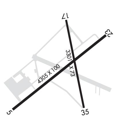
Length: 4306 ft
Width: 100 ft
Surface: ASPHALT
Edge lights: Medium Intensity

Treatment: NONE

 Runway: 05   Runway: 23
Mag heading: 47°Mag heading: 227°
Rwy Slope: .07% UpRwy Slope: -.07% Down
Approach: Approach:
Pattern: Left TrafficPattern: Left Traffic
Markings: NONPRECISION INSTRUMENTMarkings: NONPRECISION INSTRUMENT
Marking Condition: GOODMarking Condition: GOOD
Arresting Dev: Arresting Dev:
Lat & Long: N3554.8  W07542.0Lat. & Long.: N3555.4  W07541.5
Elev: 9.0 ft. MSLElev: 12.1 ft. MSL
TCH: 28 ft. AGLTCH: 31 ft. AGL
Visual Glide Path: 3.00 degreesVisual Glide Path: 4.00 degrees
Displaced Threshold: 305 feetDisplaced Threshold: 301 feet
Touchdown Zone: YESTouchdown Zone: YES
Touchdown Elev.: 12.3 feetTouchdown Elev.: 12.4 feet
Visual Glide Slope: 2-Light PAPI on LEFT side of RunwayVisual Glide Slope: 2-Light PAPI on LEFT side of Runway
RVR Equipment: RVR Equipment:
RVV Equipment: NORVV Equipment: NO
Approach Lights: Approach Lights:
REIL: YESREIL: NO
Centerline Lights: NOCenterline Lights: NO
Touchdown lights: NOTouchdown lights: NO
Runway Category: Runway with a Non-precision Approach having visibility minimums greater than 3/4 mileRunway Category: Runway with a Non-precision Approach having visibility minimums greater than 3/4 mile
Declared Distances: Declared Distances:
Obstructions: Obstructions: BLDG
Marked: Marked: NOT Marked/Lighted
Clearance slope: 34:1Clearance slope: 4:1; APCH SLOPE 11:1 AT DSPLCD THR DUE TO 15 FT ROAD 378 FT FM DSPLCD THR AND BOTH SIDES OF CNTRLN.
Obstruction height: Obstruction height: 25 feet AGL
Dist. from runway: Dist. from runway: 301 feet
Centerline offset: Centerline offset: 262 feet left of centerline
Comments: Comments: 7 FT FENCE 100-300 FT FM END OF PAVEMENT BOTH SIDES OF CNTRLN; 15 FT ROAD 90 FT FM END OF PAVEMENT AND BOTH SIDES OF CNTRLN; 12 FT TRUCK 193 FT FM END OF PAVEMENT OFFSET 120 FT LEFT OF CNTRLN.
Runway Identification: 17/35
Length: 3303 ft
Width: 75 ft
Surface: ASPHALT-GOOD CONDITION
Edge lights: Medium Intensity

Treatment: NONE

 Runway: 17   Runway: 35
Mag heading: 167°Mag heading: 347°
Rwy Slope: -.09% DownRwy Slope: .09% Up
Approach: Approach:
Pattern: Left TrafficPattern: Left Traffic
Markings: NONPRECISION INSTRUMENTMarkings: NONPRECISION INSTRUMENT
Marking Condition: GOODMarking Condition: GOOD
Arresting Dev: Arresting Dev:
Lat & Long: N3555.4  W07541.8Lat. & Long.: N3554.9  W07541.5
Elev: 12.6 ft. MSLElev: 9.5 ft. MSL
TCH: TCH:
Visual Glide Path: Visual Glide Path:
Displaced Threshold: 290 feetDisplaced Threshold: 989 feet
Touchdown Zone: YESTouchdown Zone: YES
Touchdown Elev.: 12.8 feetTouchdown Elev.: 12.8 feet
Visual Glide Slope: Visual Glide Slope:
RVR Equipment: RVR Equipment:
RVV Equipment: NORVV Equipment: NO
Approach Lights: Approach Lights:
REIL: NOREIL: NO
Centerline Lights: NOCenterline Lights: NO
Touchdown lights: NOTouchdown lights: NO
Runway Category: Runway with a Non-precision Approach having visibility minimums greater than 3/4 mileRunway Category: Runway with a Visual Approach
Declared Distances: Declared Distances:
Obstructions: TREESObstructions: TREES
Marked: NOT Marked/LightedMarked: NOT Marked/Lighted
Clearance slope: 2:1; APCH SLOPE 6:1 AT DSPLCD.Clearance slope: 5:1; APCH SLOPE 16:1 AT DSPLCD THR DUE TO 86 FT TREES 1597 FT FM DSPLCD THR OFFSET 154 FT RIGHT OF CNTRLN.
Obstruction height: 67 feet AGLObstruction height: 80 feet AGL
Dist. from runway: 364 feetDist. from runway: 615 feet
Centerline offset: 261 left of centerlineCenterline offset: 206 feet right of centerline
Comments: Comments: 9 FT BRUSH 131 FT FM END OF PAVEMENT OFFSET 16 FT RIGHT OF CNTRLN.
C:21/P: