Current Weather/Notams (Metars, TAFs, Notams, NWS Forecast, PIREPS, and nearby weather)
Customs Information Send updates to Support@FltPlan.com
Customs Not Available
Database effective 05/16/2024
Airport Diagram might not be current.
|
| Facility Name: | MC PHERSON |
| City Name: | MC PHERSON |
| County: | MC PHERSON |
| State abbrev: | KS |
| State Name: | KANSAS |
| | |
| Ownership: | PUBLICLY OWNED |
| Use: | OPEN TO THE PUBLIC |
| Owner's Name: | COUNTY & CITY OF MC PHERSON |
| Address: | 400 EAST KANSAS |
| | MC PHERSON, KS 67460 |
| Owner's Phone: | (620) 245-2535 |
| | |
| Manager's Name: | CYNTHIA PETERSON |
| Address: | 1000 S. 81 BYPASS |
| | MC PHERSON, KS 67460 |
| Phone: | 620-241-0684 |
| | |
| FAA Region: | CENTRAL |
| FAA Field Office: | NONE |
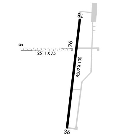
Runway Identifications
Runway Identification: 08/26Length: 2502 ft
Width: 75 ft
Surface: GRASS-GOOD CONDITION
Edge lights: Treatment: NONE
| | Runway: 08 | | Runway: 26 |
| Mag heading: | 84° | Mag heading: | 264° |
| Rwy Slope: | -.04% Down | Rwy Slope: | .04% Up |
| Approach: | | Approach: | |
| Pattern: | Left Traffic | Pattern: | Right Traffic |
| Markings: | | Markings: | |
| Marking Condition: | GOOD; RWY 08 THLD AND EDGE DELINEATED BY YELLOW CONES. | Marking Condition: | GOOD; RWY 26 THLD AND EDGE DELINEATED WITH YELLOW CONES. |
| Arresting Dev: | | Arresting Dev: | |
| Lat & Long: | N3821.3 W09741.9 | Lat. & Long.: | N3821.3 W09741.4 |
| Elev: | 1494.1 ft. MSL | Elev: | 1493.2 ft. MSL |
| TCH: | | TCH: | |
| Visual Glide Path: | | Visual Glide Path: | |
| Displaced Threshold: | No | Displaced Threshold: | No |
| Touchdown Zone: | YES | Touchdown Zone: | YES |
| Touchdown Elev.: | 1494.3 feet | Touchdown Elev.: | 1494.3 feet |
| Visual Glide Slope: | | Visual Glide Slope: | |
| RVR Equipment: | | RVR Equipment: | |
| RVV Equipment: | NO | RVV Equipment: | NO |
| Approach Lights: | | Approach Lights: | |
| REIL: | NO | REIL: | NO |
| Centerline Lights: | NO | Centerline Lights: | NO |
| Touchdown lights: | NO | Touchdown lights: | NO |
| Runway Category: | Runway with a Visual Approach | Runway Category: | Runway with a Visual Approach |
| Declared Distances: | | Declared Distances: | |
Runway Identification: 18/36Length: 5503 ft
Width: 100 ft
Surface: CONCRETE-GOOD CONDITION
Edge lights: Medium IntensityTreatment: NONE
Weight: PCN 11 /R/C/X/U
| | Runway: 18 | | Runway: 36 |
| Mag heading: | 180° | Mag heading: | 0° |
| Rwy Slope: | .02% Up | Rwy Slope: | -.02% Down |
| Approach: | | Approach: | |
| Pattern: | Right Traffic | Pattern: | Left Traffic |
| Markings: | NONPRECISION INSTRUMENT | Markings: | NONPRECISION INSTRUMENT |
| Marking Condition: | FAIR | Marking Condition: | FAIR |
| Arresting Dev: | | Arresting Dev: | |
| Lat & Long: | N3821.5 W09741.3 | Lat. & Long.: | N3820.6 W09741.5 |
| Elev: | 1493.8 ft. MSL | Elev: | 1494.8 ft. MSL |
| TCH: | 41 ft. AGL | TCH: | 39 ft. AGL |
| Visual Glide Path: | 3.00 degrees | Visual Glide Path: | 3.00 degrees |
| Displaced Threshold: | No | Displaced Threshold: | No |
| Touchdown Zone: | YES | Touchdown Zone: | YES |
| Touchdown Elev.: | 1497.3 feet | Touchdown Elev.: | 1498.3 feet |
| Visual Glide Slope: | 4-Light PAPI on LEFT side of Runway | Visual Glide Slope: | 4-Light PAPI on LEFT side of Runway |
| RVR Equipment: | | RVR Equipment: | |
| RVV Equipment: | NO | RVV Equipment: | NO |
| Approach Lights: | | Approach Lights: | |
| REIL: | YES | REIL: | YES |
| Centerline Lights: | NO | Centerline Lights: | NO |
| Touchdown lights: | NO | Touchdown lights: | NO |
| Runway Category: | Runway with a Non-precision Approach having visibility minimums greater than 3/4 mile | Runway Category: | D |
| Declared Distances: | | Declared Distances: | |


