Current Weather/Notams (Metars, TAFs, Notams, NWS Forecast, PIREPS, and nearby weather)
Customs Information Send updates to Support@FltPlan.com
Customs Not Available
Database effective 05/16/2024
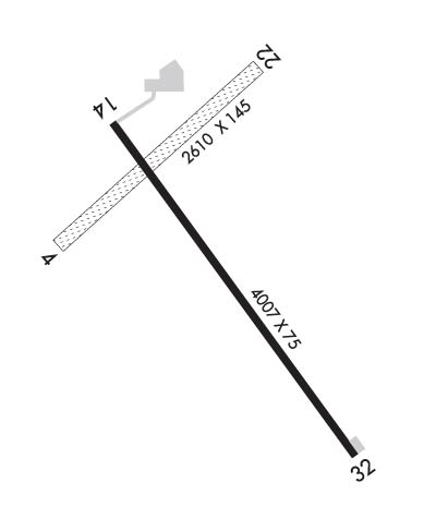
Airport Diagram might not be current.
|
| Facility Name: | MORRIS MUNI/CHARLIE SCHMIDT FLD |
| City Name: | MORRIS |
| County: | STEVENS |
| State abbrev: | MN |
| State Name: | MINNESOTA |
| | |
| Ownership: | PUBLICLY OWNED |
| Use: | OPEN TO THE PUBLIC |
| Owner's Name: | CITY OF MORRIS |
| Address: | 609 OREGON AVE, PO BOX 438 |
| | MORRIS, MN 56267-0438 |
| Owner's Phone: | 320-589-3141; AFT HRS CALL DISPATCH 320-208-6500. |
| | |
| Manager's Name: | THOMAS KLOOS |
| Address: | 50725 STATE HIGHWAY 28 |
| | MORRIS, MN 56267-4412 |
| Phone: | 320-589-2083; CELL 320-287-1645. |
| | |
| FAA Region: | GREAT LAKES |
| FAA Field Office: | DMA |
Runway Identifications
Runway Identification: 04/22Length: 2637 ft
Width: 145 ft
Surface: GRASS-GOOD CONDITION
Edge lights: Treatment: NONE
| | Runway: 04 | | Runway: 22 |
| Mag heading: | 46° | Mag heading: | 226° |
| Rwy Slope: | .49% Up | Rwy Slope: | -.49% Down |
| Approach: | | Approach: | |
| Pattern: | Left Traffic | Pattern: | Left Traffic |
| Markings: | | Markings: | |
| Marking Condition: | YELLOW CONES. | Marking Condition: | YELLOW CONES. |
| Arresting Dev: | | Arresting Dev: | |
| Lat & Long: | N4533.9 W09558.4 | Lat. & Long.: | N4534.2 W09557.9 |
| Elev: | 1122.7 ft. MSL | Elev: | 1135.7 ft. MSL |
| TCH: | | TCH: | |
| Visual Glide Path: | | Visual Glide Path: | |
| Displaced Threshold: | No | Displaced Threshold: | No |
| Touchdown Zone: | YES | Touchdown Zone: | YES |
| Touchdown Elev.: | 1135.9 feet | Touchdown Elev.: | 1135.9 feet |
| Visual Glide Slope: | | Visual Glide Slope: | |
| RVR Equipment: | | RVR Equipment: | |
| RVV Equipment: | NO | RVV Equipment: | NO |
| Approach Lights: | | Approach Lights: | |
| REIL: | NO | REIL: | NO |
| Centerline Lights: | NO | Centerline Lights: | NO |
| Touchdown lights: | NO | Touchdown lights: | NO |
| Runway Category: | Runway with a Visual Approach | Runway Category: | Runway with a Visual Approach |
| Declared Distances: | | Declared Distances: | |
Runway Identification: 14/32Length: 4899 ft
Width: 75 ft
Surface: ASPHALT-FAIR CONDITION
Edge lights: High IntensityTreatment: NONE
| | Runway: 14 | | Runway: 32 |
| Mag heading: | 142° | Mag heading: | 322° |
| Rwy Slope: | -.20% Down | Rwy Slope: | .20% Up |
| Approach: | | Approach: | |
| Pattern: | Left Traffic | Pattern: | Left Traffic |
| Markings: | NONPRECISION INSTRUMENT | Markings: | NONPRECISION INSTRUMENT |
| Marking Condition: | POOR; FADED. | Marking Condition: | GOOD |
| Arresting Dev: | | Arresting Dev: | |
| Lat & Long: | N4534.1 W09558.2 | Lat. & Long.: | N4533.5 W09557.6 |
| Elev: | 1127.5 ft. MSL | Elev: | 1117.8 ft. MSL |
| TCH: | 40 ft. AGL | TCH: | 40 ft. AGL |
| Visual Glide Path: | 3.00 degrees | Visual Glide Path: | 3.00 degrees |
| Displaced Threshold: | No | Displaced Threshold: | No |
| Touchdown Zone: | YES | Touchdown Zone: | YES |
| Touchdown Elev.: | 1131.3 feet | Touchdown Elev.: | 1129.5 feet |
| Visual Glide Slope: | 4-Light PAPI on LEFT side of Runway | Visual Glide Slope: | 4-Light PAPI on LEFT side of Runway |
| RVR Equipment: | | RVR Equipment: | |
| RVV Equipment: | NO | RVV Equipment: | NO |
| Approach Lights: | | Approach Lights: | |
| REIL: | YES | REIL: | YES |
| Centerline Lights: | NO | Centerline Lights: | NO |
| Touchdown lights: | NO | Touchdown lights: | NO |
| Runway Category: | Runway with a Non-precision Approach having visibility minimums greater than 3/4 mile | Runway Category: | Runway with a Non-precision Approach having visibility minimums greater than 3/4 mile |
| Declared Distances: | | Declared Distances: | |

