KMOT

MINOT INTL
MINOT
ND
Time Zone: Central
Lat: N 4815.5
Long: W 10116.7
Elev: 1716
Var: -06
Longest Runway: 7700
AWOS: 118.72
Ground: 121.9
Tower: 118.2

FBO & Flight Services info for KMOT

FBOs: Update your Fuel Prices

AVFLIGHTPh: 701-857-4738 Fax: 701-839-0802 Freq: 122.95
Service
Jet
100LL
SAF
MoGas
Fuel Avail: 4am to midnight, plus after hours call-out service
Full6.756.10    Last Update: 04/16/2024 12:35
PRICES GUARANTEED by FBO.
Self        
 Address: 2400 N BROADWAY MINOT,   ND 58703
ASOSPh: 701-837-9379
-
Freq: 118.72  
If you are an FBO, call 1-203-262-1700 to update your info or email: FltPlan.Advertising@garmin.com
Advertise your FBO on FltPlan.com
FBOs at nearby airports who want your business:
KFAR


  click here  
A Great Alternative to KMOT! Open 24/7, US Customs at our facility, Jet A, 100LL, competitive fuel pricing, Quick Turns, Pilots Choice Award Recipient, Recognized for Uncompromising Standards of Quality & Excellence of Service, Competitive Fuel Pricing, Quick Turns, Large Hangars up to Global/G650, Hertz on site, Avtrip Points on every gallon. www.whyfargo.com
Ph: 1-800-770-0538WebsiteE-MailFax: 1-701-237-6887Freq: 130.52

Runway & Approach Info for KMOT
Rwy
Length
Land Dist**
Approach*
  Rwy
Length
Land Dist**
Approach*
08
6348x100  5955'          
 
  
26
  6348x100  6348'          
 
13
7700x150  7700'          
 
  
31
  7700x150  7700'          
ILS/DME
 111.90 - 312°  
 * only ILS, LOC, LDA, and SDF approaches to a specific runway are shown
** For any Declared Landing Distance Available, please see A/FD or Approach plates
Runway Weight Capability (lbs.) Help
Runway IDSingle WheelDouble WheelDouble Tandem WheelDual Double Wheel
08/26120,000150,000240,000N/A
13/31120,000150,000240,000N/A
These numbers are Advisory and are not limits.   The Airport Manager should have more accurate Weight Limits
Approach Charts
Approaches    
Current Weather/Notams
Customs Information Send updates to Support@FltPlan.com
Phone 701-838-6704
Fax 701-839-3171

Comments Mon-Fri 0900-1700 *US Customs and Border Protection is available 24/7 with a 2 hour advance notice at no cost to the traveler including all holidays.
Database effective 04/18/2024
Airport Diagram of KMOT
Airport Diagram might not be current.

Facility Name: MINOT INTL
City Name: MINOT
County: WARD
State abbrev: ND
State Name: NORTH DAKOTA
   
Ownership: PUBLICLY OWNED
Use: OPEN TO THE PUBLIC
Owner's Name: CITY OF MINOT
Address: 305 AIRPORT RD., SUITE 216
 MINOT, ND 58703
Owner's Phone: 701-857-4724
  
Manager's Name: JENNIFER ECKMAN
Address: 305 AIRPORT RD, SUITE 216
 MINOT, ND 58703
Phone: 701-857-4724
   
FAA Region: GREAT LAKES
FAA Field Office: DMA


Sunrise / Sunset times for MINOT INTL

DateSunriseSunset
04/15/24 Monday6:5420:37
04/16/24 Tuesday6:5220:39
04/17/24 Wednesday6:5020:40
04/18/24 Thursday6:4820:41
04/19/24 Friday6:4620:43
04/20/24 Saturday6:4420:44
04/21/24 Sunday6:4220:46
04/22/24 Monday6:4120:47
04/23/24 Tuesday6:3920:49
04/24/24 Wednesday6:3720:50
04/25/24 Thursday6:3520:52
04/26/24 Friday6:3320:53
04/27/24 Saturday6:3220:54
04/28/24 Sunday6:3020:56

Airport Facilities

Airport Attendance ScheduleCONTINUOUS
Airport Status OPERATIONAL (This Status can change at any time - please check NOTAMS)
Airport Lighting ScheduleWHEN ATCT IS CLSD, ACTVT MALSR RWY 31; REIL RWYS 08 & 26; HIRL RWYS 08/26 & 13/31 - CTAF. PAPI RWYS 08, 13, & 26 OPR CONSLY.
Airport Storage AvailableTie Downs
Extra Services AvailableCrop Dusting, Air Ambulance, Avionics, Charter, Flight Instruction, Aircraft Rental, Aircraft Sales
Wind IndicatorYES - (lighted)
Control TowerYES
CTAF Frequency118.200
Unicom Frequency122.950
Rotating Beacon ColorWG
Segmented CircleYES
Landing FeeYES; LDG FEE FOR ALL COML FREIGHT AND COMMUTER ACFT AND ALL ACFT OVR 12500 LB.

Airport Inspection Data

Airport InspectedFEDERAL - performed by FAA AIRPORTS FIELD PERSONNEL
Inspection Date04/19/2023

Airport Services

Type of Fuel AvailableGrade 100LL, JET A (freeze point -40C)
Airframe Repair ServiceMAJOR
Power Plant Repair ServiceMAJOR

Geographic Data

LatitudeN4815.5
LongitudeW10116.7 (ESTIMATED)
Arpt Elevation1715ft (SURVEYED)
Magnetic Variation06E
2 miles Nof MINOT
Traffic Pattern Altitude
Sectional ChartBILLINGS

Aircraft Data

Operations (Reported)YearlyAvg. Daily
General Aviation Transient 1049429
General Aviation Local 1369738
Air Taxi 486913
Commerical 20206
Commuter 00
Military 19405
Aircraft based on Field
General Aviation Singles 119
General Aviation Multi 6
Jet Aircraft 1
General Aviation Helicopters 2
Military Aircraft 0
Gliders 0
Ultralights 0

FAA Services

FSS on field NO
FSS tie-in GRAND FORKS
FSS Phone 1-800-WX-BRIEF
Who issues Notams MOT
Notam D service at airport YES
ARTCC Name MINNEAPOLIS

Federal Status

Airport CertificationAIRPORT RECEIVING SCHEDULED AIR CARRIER SERVICE FROM CARRIERS CERTIFICATED BY THE CIVIL AERONAUTICS BOARD
Aircraft Rescue & Firefighting IndexAIRPORT HAS A CERTIFICATE UNDER CFR PART 139
Airport of EntryYES
Custom Landing RightsNo
Joint Civil/MilitaryNo
Military Landing rightsYES

Federal Agreements

NATIONAL PLAN OF INTEGRATED AIRPORT SYSTEMS (NPIAS)
GRANT AGREEMENTS UNDER FAAP/ADAP/AIP
ASSURANCES PURSUANT TO TITLE VI, CIVIL RIGHTS ACT OF 1964
AGREEMENT UNDER DLAND OR DCLA HAS EXPIRED.

Remarks

DEER & BIRDS INVOF ARPT.
TWYS E, B2, F, AND A ARE MKD WITH EDGE REFLECTORS.
CUSTOMS SVC AVBL 24 HRS; FOR CUSTOMS CALL 701-838-6704.
MINOT AFB (MIB) ASR OTS FOR PREVENTIVE MAINTENANCE FRIDAYS 0700-0900 & ALTN TUESDAYS 0630-0830.
RDO EQUIPD ACFT MUST ANNC ON CTAF - 118.2 WHEN TWR IS CLSD.
FOR CD IF UNA TO CTC ON FSS FREQ, CTC MINNEAPOLIS ARTCC AT 651-463-5588.
Airport Communications & Frequencies:
MAGIC CITY Tower Frequencies:   Hours(local) of operation: 0700-2200   
118.2
251.125
MAGIC CITY Ground Frequencies:
121.9
CTAF Frequency:
118.200
Unicom Frequency:
122.950
Remarks
  • APCH/DEP SVC PRVDD BY MINNEAPOLIS ARTCC ON FREQS 127.6/279.6 (MINOT RCAG) WHEN MINOT APCH CTL CLSD.
  • MINOT Primary Approach Frequencies:  
    119.6
    363.8
    MINOT Primary Departure Frequencies:  
    119.6
    259.1
    Runway Identifications
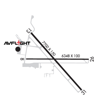
    Runway Identification: 08/26
    Length: 6348 ft
    Width: 100 ft
    Surface: ASPHALT-FAIR CONDITION
    Edge lights: High Intensity

    Treatment: GROOVED
    Weight: PCN 34 /F/D/W/T

     Runway: 08   Runway: 26
    Mag heading: 84°Mag heading: 264°
    Rwy Slope: -.91% DownRwy Slope: .91% Up
    Approach: Approach:
    Pattern: Left TrafficPattern: Left Traffic
    Markings: NONPRECISION INSTRUMENTMarkings: NONPRECISION INSTRUMENT
    Marking Condition: GOODMarking Condition: GOOD
    Arresting Dev: Arresting Dev:
    Lat & Long: N4815.5  W10117.4Lat. & Long.: N4815.5  W10115.9
    Elev: 1715.7 ft. MSLElev: 1658.2 ft. MSL
    TCH: 45 ft. AGLTCH: 49 ft. AGL
    Visual Glide Path: 3.00 degreesVisual Glide Path: 3.00 degrees
    Displaced Threshold: 393 feetDisplaced Threshold: No
    Touchdown Zone: YESTouchdown Zone: YES
    Touchdown Elev.: 1711.8 feetTouchdown Elev.: 1681.8 feet
    Visual Glide Slope: 4-Light PAPI on LEFT side of RunwayVisual Glide Slope: 4-Light PAPI on LEFT side of Runway
    RVR Equipment: RVR Equipment:
    RVV Equipment: NORVV Equipment: NO
    Approach Lights: Approach Lights:
    REIL: YESREIL: YES
    Centerline Lights: NOCenterline Lights: NO
    Touchdown lights: NOTouchdown lights: NO
    Runway Category: Runway with a Non-precision Approach having visibility minimums greater than 3/4 mileRunway Category: Runway with a Non-precision Approach having visibility minimums greater than 3/4 mile
    Declared Distances: TORA:6348' TODA:6348' ASDA:6348' LDA:5958'Declared Distances: TORA:5958' TODA:5958' ASDA:6348' LDA:6348'
    Obstructions: TREESObstructions:
    Marked: NOT Marked/LightedMarked:
    Clearance slope: 29:1; RWY 08 APCH RATIO 24:1 FM DSPLCD THLD.Clearance slope: 50:1
    Obstruction height: 57 feet AGLObstruction height:
    Dist. from runway: 1900 feetDist. from runway:
    Centerline offset: 160 left of centerlineCenterline offset:
    Comments: Comments:
    Runway Identification: 13/31
    Length: 7700 ft
    Width: 150 ft
    Surface: CONCRETE-GOOD CONDITION
    Edge lights: High Intensity

    Treatment: GROOVED
    Weight: PCN 43 /R/C/W/T

     Runway: 13   Runway: 31
    Mag heading: 132°Mag heading: 312°
    Rwy Slope: -.58% DownRwy Slope: .58% Up
    Approach: Approach: ILS/DME
    Pattern: Left TrafficPattern: Left Traffic
    Markings: PRECISION INSTRUMENTMarkings: PRECISION INSTRUMENT
    Marking Condition: GOODMarking Condition: GOOD
    Arresting Dev: Arresting Dev:
    Lat & Long: N4815.9  W10117.3Lat. & Long.: N4815.0  W10116.1
    Elev: 1701.8 ft. MSLElev: 1657.1 ft. MSL
    TCH: 49 ft. AGLTCH:
    Visual Glide Path: 3.00 degreesVisual Glide Path:
    Displaced Threshold: NoDisplaced Threshold: No
    Touchdown Zone: YESTouchdown Zone: YES
    Touchdown Elev.: 1701.8 feetTouchdown Elev.: 1679.1 feet
    Visual Glide Slope: 4-Light PAPI on LEFT side of RunwayVisual Glide Slope:
    RVR Equipment: ROLLOUTRVR Equipment: TOUCHDOWN
    RVV Equipment: NORVV Equipment: NO
    Approach Lights: Approach Lights: MALSR - 1,400 foot medium intensity approach lighting system with runway alignment indicator lights
    REIL: YESREIL: NO
    Centerline Lights: NOCenterline Lights: NO
    Touchdown lights: NOTouchdown lights: NO
    Runway Category: Runway with a Non-precision Approach having visibility minimums greater than 3/4 mileRunway Category: Precision Instrument Runway
    Declared Distances: TORA:7700' TODA:7700' ASDA:7700' LDA:7700'Declared Distances: TORA:7700' TODA:7700' ASDA:7700' LDA:7700'
    C:40/P: