Click here for more info on on SMS!

KMOR

MOORE-MURRELL
MORRISTOWN
TN
Time Zone: Eastern
Lat: N 3610.8
Long: W 08322.5
Elev: 1313
Var: +04
Longest Runway: 5717
AWOS: 126.72
CTAF: 122.8

FBO & Flight Services info for KMOR

FBOs: Update your Fuel Prices

MORRISTOWN AIR SVPh: 423-586-2483 Fax: 423-587-5483 Freq: 122.8
Service
Jet
100LL
SAF
MoGas
Fuel Avail: PRIST PREMIXED. All taxes included
Full7.667.66    Caution: Fuel prices have not been updated in 34 days.
Last Update: 03/17/2024 13:53

Self  7.66    
 Address: 5233 OLD HWY US 11 E   MORRISTOWN, TN 37814
AWOSPh: 423-587-5886
-
Freq: 126.72  
If you are an FBO, call 1-203-262-1700 to update your info or email: FltPlan.Advertising@garmin.com
Advertise your FBO on FltPlan.com

Runway & Approach Info for KMOR
Rwy
Length
Land Dist**
Approach*
  Rwy
Length
Land Dist**
Approach*
05
5717x100  5717'          
SDF/DME
 109.50 - 053°  
  
23
  5717x100  5717'          
 
 * only ILS, LOC, LDA, and SDF approaches to a specific runway are shown
** For any Declared Landing Distance Available, please see A/FD or Approach plates
Runway Weight Capability (lbs.) Help
Runway IDSingle WheelDouble WheelDouble Tandem WheelDual Double Wheel
05/2325,000N/AN/AN/A
These numbers are Advisory and are not limits.   The Airport Manager should have more accurate Weight Limits
Approach Charts
Approaches    
Current Weather/Notams
Customs Information Send updates to Support@FltPlan.com
Customs Not Available
Database effective 04/18/2024
Airport Diagram of KMOR
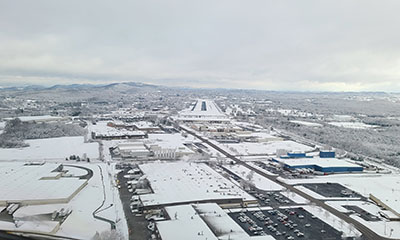
Airport Diagram might not be current.

Facility Name: MOORE-MURRELL
City Name: MORRISTOWN
County: HAMBLEN
State abbrev: TN
State Name: TENNESSEE
   
Ownership: PUBLICLY OWNED
Use: OPEN TO THE PUBLIC
Owner's Name: CITY OF MORRISTOWN
Address: CITY HALL PO BOX 1499
 MORRISTOWN, TN 37816
Owner's Phone: 423-581-0100
  
Manager's Name: ANDREW ELLARD
Address: 100 WEST FIRST NORTH STREET
 MORRISTOWN, TN 37816
Phone: (423) 585-4614
   
FAA Region: SOUTHERN
FAA Field Office: MEM
2022 - Photo courtesy of Martin Geric, Rwy 05


Click here for full scale & interactive Sectional view of KMOR


Sunrise / Sunset times for MOORE-MURRELL

DateSunriseSunset
04/19/24 Friday6:5420:11
04/20/24 Saturday6:5320:12
04/21/24 Sunday6:5220:13
04/22/24 Monday6:5020:14
04/23/24 Tuesday6:4920:15
04/24/24 Wednesday6:4820:16
04/25/24 Thursday6:4720:17
04/26/24 Friday6:4520:17
04/27/24 Saturday6:4420:18
04/28/24 Sunday6:4320:19
04/29/24 Monday6:4220:20
04/30/24 Tuesday6:4120:21
05/01/24 Wednesday6:4020:22
05/02/24 Thursday6:3920:23

Airport Facilities

Airport Attendance Schedule7 Days A Week 0800-DUSK
Airport Status OPERATIONAL (This Status can change at any time - please check NOTAMS)
Airport Lighting ScheduleACTVT VASI RWY 05; PAPI RWY 23 - CTAF.
Airport Storage AvailableTie Downs
Extra Services AvailableAir Freight, Charter, Flight Instruction, Aircraft Rental
Wind IndicatorYES - (lighted)
Control TowerNO
CTAF Frequency122.800
Unicom Frequency122.800
Rotating Beacon ColorWG
Segmented CircleYES
Landing FeeNO

Airport Inspection Data

Airport InspectedSTATE - performed by STATE AERONAUTICAL PERSONNEL
Inspection Date08/04/2021

Airport Services

Type of Fuel AvailableGrade 100LL, JET A (freeze point -40C)
Airframe Repair ServiceMAJOR
Power Plant Repair ServiceMAJOR

Geographic Data

LatitudeN3610.8
LongitudeW08322.5 (ESTIMATED)
Arpt Elevation1313ft (SURVEYED)
Magnetic Variation04W
4 miles SWof MORRISTOWN
Traffic Pattern Altitude
Sectional ChartCINCINNATI

Aircraft Data

Operations (Reported)YearlyAvg. Daily
General Aviation Transient 2500068
General Aviation Local 2300063
Air Taxi 10003
Commerical 00
Commuter 00
Military 5001
Aircraft based on Field
General Aviation Singles 44
General Aviation Multi 4
Jet Aircraft 5
General Aviation Helicopters 2
Military Aircraft 0
Gliders 0
Ultralights 0

FAA Services

FSS on field NO
FSS tie-in NASHVILLE
FSS Phone 1-800-WX-BRIEF
Who issues Notams BNA
Notam D service at airport YES
ARTCC Name ATLANTA

Federal Status

Airport Certification
Aircraft Rescue & Firefighting IndexNone
Airport of EntryNo
Custom Landing RightsNo
Joint Civil/MilitaryNo
Military Landing rightsYES

Federal Agreements

NATIONAL PLAN OF INTEGRATED AIRPORT SYSTEMS (NPIAS)
GRANT AGREEMENTS UNDER FAAP/ADAP/AIP
ASSURANCES PURSUANT TO TITLE VI, CIVIL RIGHTS ACT OF 1964

Remarks

DEER ON & INVOF ARPT.
FOR CD CTC KNOXVILLE APCH AT 865-980-3034; IF UNA FOR CD CTC KNOXVILLE APCH AT 865-980-3033.
(PAY PHONE) PAY PHONE AVAILABLE.
Airport Communications & Frequencies:
CTAF Frequency:
122.800
Unicom Frequency:
122.800
KNOXVILLE Primary Approach Frequencies:  
132.8
360.8
KNOXVILLE Primary Departure Frequencies:  
132.8
360.8
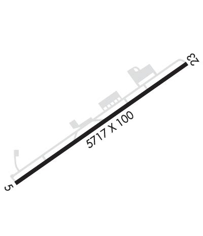
Runway Identifications
Runway Identification: 05/23
Length: 5717 ft
Width: 100 ft
Surface: ASPHALT-GOOD CONDITION
Edge lights: Medium Intensity

Treatment: NONE
Weight: PCN 174/F/C/X/T

 Runway: 05   Runway: 23
Mag heading: 53°Mag heading: 233°
Rwy Slope: -.67% DownRwy Slope: .67% Up
Approach: SDF/DMEApproach:
Pattern: Left TrafficPattern: Left Traffic
Markings: BASICMarkings: NONPRECISION INSTRUMENT
Marking Condition: GOODMarking Condition: GOOD
Arresting Dev: Arresting Dev:
Lat & Long: N3610.5  W08323.0Lat. & Long.: N3611.1  W08322.1
Elev: 1312.9 ft. MSLElev: 1274.4 ft. MSL
TCH: 39 ft. AGLTCH: 41 ft. AGL
Visual Glide Path: 3.00 degreesVisual Glide Path: 3.00 degrees
Displaced Threshold: NoDisplaced Threshold: No
Touchdown Zone: YESTouchdown Zone: YES
Touchdown Elev.: 1313.1 feetTouchdown Elev.: 1292.2 feet
Visual Glide Slope: 4-BOX VASI ON LEFT SIDE OF RUNWAYVisual Glide Slope: 2-Light PAPI on LEFT side of Runway
RVR Equipment: RVR Equipment:
RVV Equipment: NORVV Equipment: NO
Approach Lights: MALSF - 1,400 foot medium intensity approach lighting system with sequenced flashers; MALSF OTS INDEFLY.Approach Lights:
REIL: YESREIL: YES
Centerline Lights: NOCenterline Lights: NO
Touchdown lights: NOTouchdown lights: NO
Runway Category: DRunway Category: Runway with a Non-precision Approach having visibility minimums greater than 3/4 mile
Declared Distances: Declared Distances:
Obstructions: TREEObstructions: TREE
Marked: NOT Marked/LightedMarked: NOT Marked/Lighted
Clearance slope: 29:1Clearance slope: 15:1
Obstruction height: 84 feet AGLObstruction height: 33 feet AGL
Dist. from runway: 2636 feetDist. from runway: 705 feet
Centerline offset: 476 left of centerlineCenterline offset: 192 feet right of centerline
Comments: Comments:
C:14/P: