Click here for more info on on SMS!

KMOD

MODESTO CITY-CO-HARRY SHAM FLD
MODESTO
CA
Time Zone: Pacific
Lat: N 3737.5
Long: W 12057.3
Elev: 99
Var: -16
Longest Runway: 5904
Dept. ATIS: 127.7
Arr. ATIS: 127.7
AWOS: 127.7
Ground: 121.7
Tower: 125.3

FBO & Flight Services info for KMOD

FBOs: Update your Fuel Prices

  click here  
Sky Trek Aviation is now Modesto Jet Center. A fresh beginning with a 30 year history of excellence. We provide full FBO services, 24/7 operations, competitive pricing, quick-turn service, a 145 repair station on site, hangar space, well-appointed facilities and complimentary refreshments, ice and newspaper.
Ph: 209-577-4654 Fax: 209-525-8677 Freq: 132.0WebsiteE-Mail
                     
Service
Jet
100LL
SAF
MoGas
Fuel Avail: PRIST + $0.10/gal. Line Service Open 24/7!!! RAMP FEE WAIVED w/ min. fuel purchase.
Full6.497.49    Last Update: 04/10/2024 11:21
PRICES GUARANTEED by FBO. *
*All Taxes Included
Self  6.49    
Misc. Info: RAMP FEE WAIVED with minimum fuel purchase. MFP varies per type A/C.Address: 825 AIRPORT WAY   MODESTO, CA 95354

ASOSPh: 209-572-0914
-
Freq: 127.7  
If you are an FBO, call 1-203-262-1700 to update your info or email: FltPlan.Advertising@garmin.com
Advertise your FBO on FltPlan.com

Runway & Approach Info for KMOD
Rwy
Length
Land Dist**
Approach*
  Rwy
Length
Land Dist**
Approach*
10L
5904x150  5904'          
 
  
28R
  5904x150  5904'          
ILS
 111.90 - 288°  
10R
3464x100  3464'          
 
  
28L
  3464x100  3464'          
 
 * only ILS, LOC, LDA, and SDF approaches to a specific runway are shown
** For any Declared Landing Distance Available, please see A/FD or Approach plates
Runway Weight Capability (lbs.) Help
Runway IDSingle WheelDouble WheelDouble Tandem WheelDual Double Wheel
10L/28R60,000200,000400,000N/A
10R/28L30,000N/AN/AN/A
These numbers are Advisory and are not limits.   The Airport Manager should have more accurate Weight Limits
Approach Charts
Approaches    
Current Weather/Notams
Customs Information Send updates to Support@FltPlan.com
Customs Not Available
Database effective 04/18/2024
Airport Diagram of KMOD
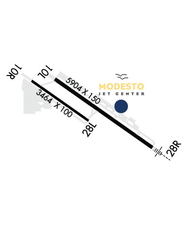
Airport Diagram might not be current.

Facility Name: MODESTO CITY-COUNTY-HARRY SHAM FLD
City Name: MODESTO
County: STANISLAUS
State abbrev: CA
State Name: CALIFORNIA
   
Ownership: PUBLICLY OWNED
Use: OPEN TO THE PUBLIC
Owner's Name: CITY OF MODESTO
Address: PO BOX 642
 MODESTO, CA 95353
Owner's Phone: 209-577-5318
  
Manager's Name: GABE DA SILVA
Address: 617 AIRPORT WAY
 MODESTO, CA 95354-3916
Phone: 209-577-5318
   
FAA Region: WESTERN-PACIFIC
FAA Field Office: SFO


Sunrise / Sunset times for MODESTO CITY-COUNTY-HARRY SHAM FLD

DateSunriseSunset
04/18/24 Thursday6:2419:43
04/19/24 Friday6:2219:44
04/20/24 Saturday6:2119:45
04/21/24 Sunday6:2019:46
04/22/24 Monday6:1819:47
04/23/24 Tuesday6:1719:47
04/24/24 Wednesday6:1619:48
04/25/24 Thursday6:1519:49
04/26/24 Friday6:1319:50
04/27/24 Saturday6:1219:51
04/28/24 Sunday6:1119:52
04/29/24 Monday6:1019:53
04/30/24 Tuesday6:0919:54
05/01/24 Wednesday6:0719:55

Airport Facilities

Airport Attendance ScheduleMON-FRI 0800 -1630
Airport Status OPERATIONAL (This Status can change at any time - please check NOTAMS)
Airport Lighting ScheduleWHEN ATCT CLSD, ACTVT MALSR RWY 28R, REIL RWY 10L, HIRL RWY 10L/28R - CTAF. PAPI RWYS 10R & 28L AND MIRL RWY 10R/28L UNAVBL WHEN ATCT CLSD.
Airport Storage AvailableTie Downs, Hanger
Extra Services AvailableAir Freight, Air Ambulance, Avionics, Cargo Handling, Charter, Flight Instruction, Aircraft Rental, Aircraft Sales
Wind IndicatorYES - (lighted)
Control TowerYES
CTAF Frequency125.300
Unicom Frequency122.950
Rotating Beacon ColorWG
Segmented CircleYES
Landing FeeNO; OVERNGT TIEDOWN FEE

Airport Inspection Data

Airport InspectedFEDERAL - performed by STATE AERONAUTICAL PERSONNEL
Inspection Date07/20/2023

Airport Services

Type of Fuel AvailableGrade 100LL, JET A (freeze point -40C), JET A-1 (icing inhibitor, freeze point -50C)
Airframe Repair ServiceMAJOR
Power Plant Repair ServiceMAJOR

Geographic Data

LatitudeN3737.5
LongitudeW12057.3 (ESTIMATED)
Arpt Elevation99ft (SURVEYED)
Magnetic Variation16E
2 miles SEof MODESTO
Traffic Pattern Altitude
Sectional ChartSAN FRANCISCO

Aircraft Data

Operations (Reported)YearlyAvg. Daily
General Aviation Transient 2332864
General Aviation Local 1152732
Air Taxi 938726
Commerical 00
Commuter 00
Military 2791
Aircraft based on Field
General Aviation Singles 111
General Aviation Multi 16
Jet Aircraft 9
General Aviation Helicopters 6
Military Aircraft 0
Gliders 0
Ultralights 0

FAA Services

FSS on field NO
FSS tie-in RANCHO MURIETA
FSS Phone 1-800-WX-BRIEF
Who issues Notams MOD
Notam D service at airport YES
ARTCC Name OAKLAND

Federal Status

Airport CertificationPPR 72 HRS FOR ACR OPNS WITH MORE THAN 30 PSGR SEATS 0800-1700 WKDAYS CALL AMGR (209) 577-5318.
Aircraft Rescue & Firefighting IndexNone
Airport of EntryNo
Custom Landing RightsNo
Joint Civil/MilitaryNo
Military Landing rightsYES

Federal Agreements

NATIONAL PLAN OF INTEGRATED AIRPORT SYSTEMS (NPIAS)
GRANT AGREEMENTS UNDER FAAP/ADAP/AIP
ASSURANCES PURSUANT TO TITLE VI, CIVIL RIGHTS ACT OF 1964

Remarks

IN THE INTEREST OF NOISE ABATEMENT: TUBO JETS DISCONTINUE OPNS 2400-0500 LCL & PARK ON NE RAMP.
FOR CD WHEN ATCT CLSD CTC NORCAL APCH AT 916-361-0516.
BIRDS AND SMALL MAMMALS ON AND IN VICINITY OF AP.
ALL PURE JET AND LARGE ACFT LMTD TO PRKG AND SVC AT NE RAMP ONLY.
AVIATION WX AVBL WHEN ATCT OPNL CALL 209-526-4555.
NOISE ABATEMENT PROCEDURES: PILOTS ARE REQUESTED TO USE LGTD RWY ONLY.
RWY 10R/28L NOT CERTIFICATED FOR FAR-139.
PONDING ALONG NORTH EDGE OF TWY B DURING AND AFTER WET WEATHER.
RWY 10R/ 28L
Airport Communications & Frequencies:
ATIS Frequencies:   Hours(local) of Operation: CONTINUOUS
127.7
MODESTO Tower Frequencies:   Hours(local) of operation: 0700-2100   
125.3
257.8
MODESTO Ground Frequencies:
121.7
CTAF Frequency:
125.300
Unicom Frequency:
122.950
NORCAL Primary Approach Frequencies:  
120.95
269.45
NORCAL Primary Departure Frequencies:  
120.95 060-205 MOD
123.85 WEST
125.1 NORTH
269.45
269.45 060-205 MOD
278.3 WEST
363.2 NORTH
Runway Identifications
Runway Identification: 10L/28R
Length: 5904 ft
Width: 150 ft
Surface: ASPHALT-GOOD CONDITION
Edge lights: High Intensity

Treatment: GROOVED
Weight: PCN 38 /F/C/X/T

 Runway: 10L   Runway: 28R
Mag heading: 108°Mag heading: 288°
Rwy Slope: -.30% DownRwy Slope: .30% Up
Approach: Approach: ILS
Pattern: Left TrafficPattern: Right Traffic
Markings: PRECISION INSTRUMENTMarkings: PRECISION INSTRUMENT
Marking Condition: GOODMarking Condition: GOOD
Arresting Dev: Arresting Dev:
Lat & Long: N3737.8  W12057.6Lat. & Long.: N3737.2  W12056.6
Elev: 99.1 ft. MSLElev: 81.5 ft. MSL
TCH: 50 ft. AGLTCH:
Visual Glide Path: 3.00 degreesVisual Glide Path:
Displaced Threshold: NoDisplaced Threshold: No
Touchdown Zone: YESTouchdown Zone: YES
Touchdown Elev.: 99.2 feetTouchdown Elev.: 90.8 feet
Visual Glide Slope: 4-BOX VASI ON LEFT SIDE OF RUNWAYVisual Glide Slope:
RVR Equipment: RVR Equipment:
RVV Equipment: NORVV Equipment: NO
Approach Lights: Approach Lights: MALSR - 1,400 foot medium intensity approach lighting system with runway alignment indicator lights
REIL: YESREIL: NO
Centerline Lights: NOCenterline Lights: NO
Touchdown lights: NOTouchdown lights: NO
Runway Category: Runway with a Visual ApproachRunway Category: Precision Instrument Runway
Declared Distances: TORA:5904' TODA:5904' ASDA:5904' LDA:5904'Declared Distances: TORA:5904' TODA:5904' ASDA:5904' LDA:5904'
Obstructions: TREEObstructions: ROAD
Marked: NOT Marked/LightedMarked: NOT Marked/Lighted
Clearance slope: 34:1Clearance slope: 50:1
Obstruction height: 73 feet AGLObstruction height: 14 feet AGL
Dist. from runway: 2700 feetDist. from runway: 1600 feet
Centerline offset: 450 right of centerlineCenterline offset:
Comments: Comments:
Runway Identification: 10R/28L
Length: 3464 ft
Width: 100 ft
Surface: ASPHALT-GOOD CONDITION
Edge lights: Medium Intensity

Treatment: NONE
Weight: PCN 8 /F/C/X/T

 Runway: 10R   Runway: 28L
Mag heading: 108°Mag heading: 288°
Rwy Slope: -.36% DownRwy Slope: .36% Up
Approach: Approach:
Pattern: Right TrafficPattern: Left Traffic
Markings: BASICMarkings: BASIC
Marking Condition: GOODMarking Condition: GOOD
Arresting Dev: Arresting Dev:
Lat & Long: N3737.8  W12057.8Lat. & Long.: N3737.5  W12057.3
Elev: 98.4 ft. MSLElev: 85.8 ft. MSL
TCH: 40 ft. AGLTCH: 29 ft. AGL
Visual Glide Path: 3.50 degreesVisual Glide Path: 3.00 degrees
Displaced Threshold: NoDisplaced Threshold: No
Touchdown Zone: YESTouchdown Zone: YES
Touchdown Elev.: 99.0 feetTouchdown Elev.: 98.9 feet
Visual Glide Slope: 2-Light PAPI on LEFT side of RunwayVisual Glide Slope: 2-Light PAPI on LEFT side of Runway
RVR Equipment: RVR Equipment:
RVV Equipment: NORVV Equipment: NO
Approach Lights: Approach Lights:
REIL: NOREIL: NO
Centerline Lights: NOCenterline Lights: NO
Touchdown lights: NOTouchdown lights: NO
Runway Category: Runway with a Visual ApproachRunway Category: Runway with a Visual Approach
Declared Distances: TORA:3464' TODA:3464' ASDA:3464' LDA:3464'Declared Distances: TORA:3464' TODA:3464' ASDA:3464' LDA:3464'
Obstructions: TREEObstructions: TREE
Marked: NOT Marked/LightedMarked: NOT Marked/Lighted
Clearance slope: 20:1Clearance slope: 31:1
Obstruction height: 56 feet AGLObstruction height: 47 feet AGL
Dist. from runway: 1340 feetDist. from runway: 1700 feet
Centerline offset: 75 left of centerlineCenterline offset: 50 feet right of centerline
Comments: Comments:
C:30/P: