| ||||||||||||||||||||||||||||||||||||||||||||||||||||||||||||||||||||
| ||||||||||||||||||||||||||||||||||||||||||||||||||||||||||||||||||||
| ||||||||||||||||||||||||||||||||||||||||||||||||||||||||||||||||||||
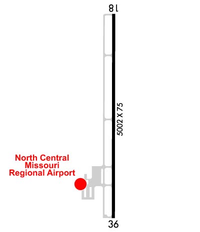
| Rwy | Rwy | |||||||
| 5002x75 | 5002' | 5002x75 | 5002' | |||||
| Runway ID | Single Wheel | Double Wheel | Double Tandem Wheel | Dual Double Wheel |
| 18/36 | 30,000 | N/A | N/A | N/A |
| These numbers are Advisory and are not limits. The Airport Manager should have more accurate Weight Limits | ||||
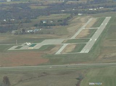
 Airport Diagram might not be current. | |
| Facility Name: | NORTH CENTRAL MISSOURI RGNL |
| City Name: | BROOKFIELD |
| County: | LINN |
| State abbrev: | MO |
| State Name: | MISSOURI |
| Ownership: | PUBLICLY OWNED |
| Use: | OPEN TO THE PUBLIC |
| Owner's Name: | CITIES OF BROOKFIELD & MARCELINE |
| Address: | 116 WEST BROOKS |
| BROOKFIELD, MO 64628 | |
| Owner's Phone: | 660-591-2420 |
| Manager's Name: | RANDY STOCKWELL |
| Address: | 28540 JET WAY DRIVE, PO BOX 283 |
| BROOKFIELD, MO 64628 | |
| Phone: | 660-258-7317 |
| FAA Region: | CENTRAL |
| FAA Field Office: | NONE |
| Date | Sunrise | Sunset |
|---|---|---|
| 04/30/24 Tuesday | 6:13 | 20:06 |
| 05/01/24 Wednesday | 6:12 | 20:07 |
| 05/02/24 Thursday | 6:10 | 20:08 |
| 05/03/24 Friday | 6:09 | 20:09 |
| 05/04/24 Saturday | 6:08 | 20:10 |
| 05/05/24 Sunday | 6:07 | 20:11 |
| 05/06/24 Monday | 6:06 | 20:12 |
| 05/07/24 Tuesday | 6:05 | 20:13 |
| 05/08/24 Wednesday | 6:04 | 20:14 |
| 05/09/24 Thursday | 6:02 | 20:15 |
| 05/10/24 Friday | 6:01 | 20:16 |
| 05/11/24 Saturday | 6:00 | 20:17 |
| 05/12/24 Sunday | 5:59 | 20:18 |
| 05/13/24 Monday | 5:58 | 20:19 |
| Airport Attendance Schedule | IRREGULAR |
| Airport Status | OPERATIONAL (This Status can change at any time - please check NOTAMS) |
| Airport Lighting Schedule | ACTVT MIRL RY 18/36; PAPI RYS 18 & 36; REIL RYS 18 & 36 - CTAF. |
| Airport Storage Available | Tie Downs |
| Extra Services Available | NONE |
| Wind Indicator | YES - (lighted) |
| Control Tower | NO |
| CTAF Frequency | 122.900 |
| Unicom Frequency | |
| Rotating Beacon Color | WG |
| Segmented Circle | YES |
| Landing Fee |
| Airport Inspected | STATE - performed by STATE AERONAUTICAL PERSONNEL |
| Inspection Date | 07/19/2023 |
| Type of Fuel Available | Grade 100LL, JET A (freeze point -40C); -10SELF-SERVICE FUEL AVAILABLE 24 HRS. |
| Airframe Repair Service | None |
| Power Plant Repair Service | None |
| Latitude | N3946.3 |
| Longitude | W09300.8 (ESTIMATED) |
| Arpt Elevation | 844ft (SURVEYED) |
| Magnetic Variation | 00W |
| 2 miles E | of BROOKFIELD |
| Traffic Pattern Altitude | |
| Sectional Chart | KANSAS CITY |
| Operations (Reported) | Yearly | Avg. Daily |
|---|---|---|
| General Aviation Transient | 2210 | 6 |
| General Aviation Local | 730 | 2 |
| Air Taxi | 0 | 0 |
| Commerical | 0 | 0 |
| Commuter | 0 | 0 |
| Military | 40 | 0 |
| Aircraft based on Field | |
|---|---|
| General Aviation Singles | 9 |
| General Aviation Multi | 2 |
| Jet Aircraft | 0 |
| General Aviation Helicopters | 0 |
| Military Aircraft | 0 |
| Gliders | 0 |
| Ultralights | 0 |
| FSS on field | NO |
| FSS tie-in | COLUMBIA |
| FSS Phone | 1-800-WX-BRIEF |
| Who issues Notams | COU |
| Notam D service at airport | YES |
| ARTCC Name | KANSAS CITY |
| Airport Certification | |
| Aircraft Rescue & Firefighting Index | None |
| Airport of Entry | No |
| Custom Landing Rights | No |
| Joint Civil/Military | No |
| Military Landing rights | No |
| NATIONAL PLAN OF INTEGRATED AIRPORT SYSTEMS (NPIAS) |
| FOR SERVICE AFTER HRS, CALL PHONE NUMBERS POSTED ON AIRPORT MGMT OFFICE DOOR. |
| NUMEROUS WATERFOWL & DEER ON & INVOF ARPT. |
| FOR CD CTC KANSAS CITY ARTCC AT 913-254-8508. |
Airport Communications & Frequencies:
| |||||||
| Runway: 18 | Runway: 36 | ||
| Mag heading: | 181° | Mag heading: | 1° |
| Rwy Slope: | -.37% Down | Rwy Slope: | .37% Up |
| Approach: | Approach: | ||
| Pattern: | Left Traffic | Pattern: | Left Traffic |
| Markings: | NONPRECISION INSTRUMENT | Markings: | NONPRECISION INSTRUMENT |
| Marking Condition: | GOOD | Marking Condition: | GOOD |
| Arresting Dev: | Arresting Dev: | ||
| Lat & Long: | N3946.7 W09300.8 | Lat. & Long.: | N3945.9 W09300.8 |
| Elev: | 844.3 ft. MSL | Elev: | 825.6 ft. MSL |
| TCH: | 40 ft. AGL | TCH: | 38 ft. AGL |
| Visual Glide Path: | 3.00 degrees | Visual Glide Path: | 3.00 degrees |
| Displaced Threshold: | No | Displaced Threshold: | No |
| Touchdown Zone: | YES | Touchdown Zone: | YES |
| Touchdown Elev.: | 844.5 feet | Touchdown Elev.: | 834.7 feet |
| Visual Glide Slope: | 4-Light PAPI on LEFT side of Runway | Visual Glide Slope: | 4-Light PAPI on LEFT side of Runway |
| RVR Equipment: | RVR Equipment: | ||
| RVV Equipment: | NO | RVV Equipment: | NO |
| Approach Lights: | Approach Lights: | ||
| REIL: | YES | REIL: | YES |
| Centerline Lights: | NO | Centerline Lights: | NO |
| Touchdown lights: | NO | Touchdown lights: | NO |
| Runway Category: | Runway with a Non-precision Approach having visibility minimums greater than 3/4 mile | Runway Category: | Runway with a Non-precision Approach having visibility minimums greater than 3/4 mile |
| Declared Distances: | Declared Distances: |