Approach Charts
| FltPlan does not have IFR approach charts available for KMO1. |
Current Weather/Notams (Metars, TAFs, Notams, NWS Forecast, PIREPS, and nearby weather)
Customs Information Send updates to Support@FltPlan.com
Customs Not Available
Database effective 05/16/2024
Airport Diagram might not be current.
|
| Facility Name: | RICHLAND MUNI |
| City Name: | RICHLAND |
| County: | PULASKI |
| State abbrev: | MO |
| State Name: | MISSOURI |
| | |
| Ownership: | PUBLICLY OWNED |
| Use: | OPEN TO THE PUBLIC |
| Owner's Name: | CITY OF RICHLAND |
| Address: | PO BOX 798 |
| | RICHLAND, MO 65556 |
| Owner's Phone: | 573-765-4421 |
| | |
| Manager's Name: | DANA TANNER; MAYOR |
| Address: | PO BOX 798 |
| | RICHLAND, MO 65556 |
| Phone: | 573-765-3532 |
| | |
| FAA Region: | CENTRAL |
| FAA Field Office: | NONE |
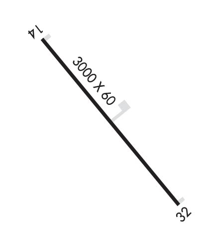
Runway Identifications
Runway Identification: 14/32Length: 3000 ft
Width: 60 ft
Surface: ASPHALT-GOOD CONDITION
Edge lights: Low IntensityTreatment: NONE
| | Runway: 14 | | Runway: 32 |
| Mag heading: | N/A | Mag heading: | N/A |
| Rwy Slope: | .00% | Rwy Slope: | .00% |
| Approach: | | Approach: | |
| Pattern: | Left Traffic | Pattern: | Left Traffic |
| Markings: | BASIC | Markings: | BASIC |
| Marking Condition: | GOOD | Marking Condition: | GOOD |
| Arresting Dev: | | Arresting Dev: | |
| Lat & Long: | N3752.7 W09224.7 | Lat. & Long.: | N3752.3 W09224.3 |
| Elev: | 1110.0 ft. MSL | Elev: | 1110.0 ft. MSL |
| TCH: | | TCH: | |
| Visual Glide Path: | | Visual Glide Path: | |
| Displaced Threshold: | 170 feet | Displaced Threshold: | 130 feet |
| Touchdown Zone: | NO | Touchdown Zone: | NO |
| Touchdown Elev.: | | Touchdown Elev.: | |
| Visual Glide Slope: | | Visual Glide Slope: | |
| RVR Equipment: | | RVR Equipment: | |
| RVV Equipment: | NO | RVV Equipment: | NO |
| Approach Lights: | | Approach Lights: | |
| REIL: | NO | REIL: | NO |
| Centerline Lights: | NO | Centerline Lights: | NO |
| Touchdown lights: | NO | Touchdown lights: | NO |
| Runway Category: | Runway with a Visual Approach | Runway Category: | Runway with a Visual Approach |
| Declared Distances: | | Declared Distances: | |
| Obstructions: | TREES | Obstructions: | TREES |
| Marked: | NOT Marked/Lighted | Marked: | NOT Marked/Lighted |
| Clearance slope: | 5:1; RWY 14 +40 FT TREES, 588 FT, 150FT L-R, 14:1 BASED ON DSPLCD THLD. | Clearance slope: | RWY 32 APCH SLOPE 9:1, +32 FT TREES, 302 FT FM DSPLCD THLD, 50 FT L/R, |
| Obstruction height: | 40 feet AGL | Obstruction height: | 32 feet AGL |
| Dist. from runway: | 418 feet | Dist. from runway: | 202 feet |
| Centerline offset: | 150 right of centerline | Centerline offset: | 125 feet right of centerline |
| Comments: | | Comments: | RWY 32 +1-6 FT GND; TREE, 35 FT, 55 FT FM RWY END 70 FT R; TREES 18-35 FT, 180-200 FT FM RWY END, L & R. |

