Current Weather/Notams (Metars, TAFs, Notams, NWS Forecast, PIREPS, and nearby weather)
Customs Information Send updates to Support@FltPlan.com
Customs Not Available
Database effective 04/18/2024
Airport Diagram might not be current.
|
| Facility Name: | MENOMINEE RGNL |
| City Name: | MENOMINEE |
| County: | MENOMINEE |
| State abbrev: | MI |
| State Name: | MICHIGAN |
| | |
| Ownership: | PUBLICLY OWNED |
| Use: | OPEN TO THE PUBLIC |
| Owner's Name: | MENOMINEE COUNTY |
| Address: | 2801 22ND ST |
| | MENOMINEE, MI 49858-3401 |
| Owner's Phone: | 906-863-8408 |
| | |
| Manager's Name: | JEFF LAFLEUR |
| Address: | 2801 22ND ST |
| | MENOMINEE, MI 49858-3401 |
| Phone: | 715-938-2006; CELL. |
| | |
| FAA Region: | GREAT LAKES |
| FAA Field Office: | DET |
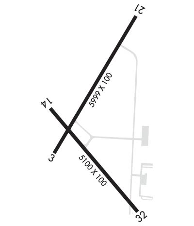
Runway Identifications
Runway Identification: 03/21Length: 5999 ft
Width: 100 ft
Surface: ASPHALT-GOOD CONDITION
Edge lights: High IntensityTreatment: POROUS FRICTION COURSE
| | Runway: 03 | | Runway: 21 |
| Mag heading: | 34° | Mag heading: | 214° |
| Rwy Slope: | .12% Up | Rwy Slope: | -.12% Down |
| Approach: | ILS | Approach: | |
| Pattern: | Left Traffic | Pattern: | Left Traffic |
| Markings: | PRECISION INSTRUMENT | Markings: | PRECISION INSTRUMENT |
| Marking Condition: | GOOD | Marking Condition: | GOOD |
| Arresting Dev: | | Arresting Dev: | |
| Lat & Long: | N4507.4 W08738.7 | Lat. & Long.: | N4508.2 W08737.9 |
| Elev: | 614.4 ft. MSL | Elev: | 621.8 ft. MSL |
| TCH: | | TCH: | 42 ft. AGL |
| Visual Glide Path: | | Visual Glide Path: | 3.00 degrees |
| Displaced Threshold: | No | Displaced Threshold: | No |
| Touchdown Zone: | YES | Touchdown Zone: | YES |
| Touchdown Elev.: | 624.0 feet | Touchdown Elev.: | 624.6 feet |
| Visual Glide Slope: | | Visual Glide Slope: | 4-Light PAPI on LEFT side of Runway |
| RVR Equipment: | | RVR Equipment: | |
| RVV Equipment: | NO | RVV Equipment: | NO |
| Approach Lights: | MALSR - 1,400 foot medium intensity approach lighting system with runway alignment indicator lights | Approach Lights: | |
| REIL: | NO | REIL: | NO |
| Centerline Lights: | NO | Centerline Lights: | NO |
| Touchdown lights: | NO | Touchdown lights: | NO |
| Runway Category: | Precision Instrument Runway | Runway Category: | Runway with a Non-precision Approach having visibility minimums greater than 3/4 mile |
| Declared Distances: | | Declared Distances: | |
| Obstructions: | | Obstructions: | TREE |
| Marked: | | Marked: | NOT Marked/Lighted |
| Clearance slope: | 50:1 | Clearance slope: | 21:1 |
| Obstruction height: | | Obstruction height: | 70 feet AGL |
| Dist. from runway: | | Dist. from runway: | 1703 feet |
| Centerline offset: | | Centerline offset: | 383 feet left of centerline |
| Comments: | | Comments: | |
Runway Identification: 14/32Length: 5101 ft
Width: 100 ft
Surface: ASPHALT-GOOD CONDITION
Edge lights: Medium IntensityTreatment: NONE
| | Runway: 14 | | Runway: 32 |
| Mag heading: | 143° | Mag heading: | 323° |
| Rwy Slope: | -.32% Down | Rwy Slope: | .32% Up |
| Approach: | | Approach: | |
| Pattern: | Left Traffic | Pattern: | Left Traffic |
| Markings: | NONPRECISION INSTRUMENT | Markings: | NONPRECISION INSTRUMENT |
| Marking Condition: | GOOD | Marking Condition: | GOOD |
| Arresting Dev: | | Arresting Dev: | |
| Lat & Long: | N4507.7 W08738.7 | Lat. & Long.: | N4507.0 W08737.9 |
| Elev: | 621.2 ft. MSL | Elev: | 605.1 ft. MSL |
| TCH: | 47 ft. AGL | TCH: | 52 ft. AGL |
| Visual Glide Path: | 4.00 degrees | Visual Glide Path: | 4.00 degrees |
| Displaced Threshold: | No | Displaced Threshold: | No |
| Touchdown Zone: | YES | Touchdown Zone: | YES |
| Touchdown Elev.: | 621.2 feet | Touchdown Elev.: | 608.3 feet |
| Visual Glide Slope: | 4-Light PAPI on RIGHT side of Runway | Visual Glide Slope: | 4-Light PAPI on LEFT side of Runway |
| RVR Equipment: | | RVR Equipment: | |
| RVV Equipment: | NO | RVV Equipment: | NO |
| Approach Lights: | | Approach Lights: | |
| REIL: | NO | REIL: | NO |
| Centerline Lights: | NO | Centerline Lights: | NO |
| Touchdown lights: | NO | Touchdown lights: | NO |
| Runway Category: | Runway with a Visual Approach | Runway Category: | Runway with a Non-precision Approach having visibility minimums greater than 3/4 mile |
| Declared Distances: | | Declared Distances: | |
| Obstructions: | TREES | Obstructions: | TREE |
| Marked: | NOT Marked/Lighted | Marked: | NOT Marked/Lighted |
| Clearance slope: | 3:1 | Clearance slope: | 10:1 |
| Obstruction height: | 48 feet AGL | Obstruction height: | 49 feet AGL |
| Dist. from runway: | 351 feet | Dist. from runway: | 738 feet |
| Centerline offset: | 266 right of centerline | Centerline offset: | 238 feet left of centerline |
| Comments: | | Comments: | |

