Click here for more info on on SMS!

KMNE

MINDEN-WEBSTER
MINDEN
LA
Time Zone: Central
Lat: N 3238.8
Long: W 09317.9
Elev: 278
Var: -04
Longest Runway: 5004
Clr Del: 135.07 GCO
AWOS: 119.32
CTAF: 122.8

FBO & Flight Services info for KMNE

FBOs: Update your Fuel Prices

MINDEN AIRPORTPh: 318-371-7862 Fax: 318-377-6789 Freq: 122.8
Service
Jet
100LL
SAF
MoGas
Fuel Avail: 0800-1700L w/ after hours available by calling 318-377-2144 EXT 0
Full5.085.35    Last Update: 04/08/2024 10:53

Self4.394.95    
 Address: 341 METHODIST CAMP RD   MINDEN, LA 71055
AWOSPh: 318-371-7874
-
Freq: 119.32  
If you are an FBO, call 1-203-262-1700 to update your info or email: FltPlan.Advertising@garmin.com
Advertise your FBO on FltPlan.com

Runway & Approach Info for KMNE
Rwy
Length
Land Dist**
Approach*
  Rwy
Length
Land Dist**
Approach*
01
5004x75  5004'          
 
  
19
  5004x75  5004'          
 
 * only ILS, LOC, LDA, and SDF approaches to a specific runway are shown
** For any Declared Landing Distance Available, please see A/FD or Approach plates
Runway Weight Capability (lbs.) Help
Runway IDSingle WheelDouble WheelDouble Tandem WheelDual Double Wheel
01/1930,00045,000N/AN/A
These numbers are Advisory and are not limits.   The Airport Manager should have more accurate Weight Limits
Approach Charts
Approaches    
Current Weather/Notams
Customs Information Send updates to Support@FltPlan.com
Customs Not Available
Database effective 04/18/2024
Airport Diagram of KMNE
Airport Diagram might not be current.
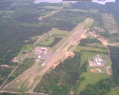
Facility Name: MINDEN
City Name: MINDEN
County: WEBSTER
State abbrev: LA
State Name: LOUISIANA
   
Ownership: PUBLICLY OWNED
Use: OPEN TO THE PUBLIC
Owner's Name: CITY OF MINDEN
Address: PO BOX 580
 MINDEN, LA 71055-0580
Owner's Phone: 318-377-2144
  
Manager's Name: STEVEN BURDEAUX
Address: 100 AVIATION DRIVE
 MINDEN, LA 71055
Phone: 318-371-7862
   
FAA Region: SOUTHWEST
FAA Field Office: LNM


Sunrise / Sunset times for MINDEN

DateSunriseSunset
04/15/24 Monday6:4319:44
04/16/24 Tuesday6:4219:44
04/17/24 Wednesday6:4019:45
04/18/24 Thursday6:3919:46
04/19/24 Friday6:3819:47
04/20/24 Saturday6:3719:47
04/21/24 Sunday6:3619:48
04/22/24 Monday6:3519:49
04/23/24 Tuesday6:3419:50
04/24/24 Wednesday6:3319:50
04/25/24 Thursday6:3219:51
04/26/24 Friday6:3019:52
04/27/24 Saturday6:2919:52
04/28/24 Sunday6:2819:53

Airport Facilities

Airport Attendance Schedule7 Days A Week 0800-1800; FOR ARPT ATTENDANT AFT HRS CALL 318-377-2144.
Airport Status OPERATIONAL (This Status can change at any time - please check NOTAMS)
Airport Lighting ScheduleACTVT MIRL RY 01/19 - CTAF.
Airport Storage AvailableTie Downs, Hanger
Extra Services AvailableFlight Instruction
Wind IndicatorYES - (lighted)
Control TowerNO
CTAF Frequency122.800
Unicom Frequency122.800
Rotating Beacon ColorWG
Segmented CircleNO
Landing FeeNO

Airport Inspection Data

Airport InspectedSTATE - performed by STATE AERONAUTICAL PERSONNEL
Inspection Date10/24/2023

Airport Services

Type of Fuel AvailableGrade 100LL, JET A
Airframe Repair ServiceNone
Power Plant Repair ServiceNone

Geographic Data

LatitudeN3238.8
LongitudeW09317.9 (ESTIMATED)
Arpt Elevation278ft (SURVEYED)
Magnetic Variation04E
2 miles NWof MINDEN
Traffic Pattern Altitude1022
Sectional ChartMEMPHIS

Aircraft Data

Operations (Reported)YearlyAvg. Daily
General Aviation Transient 22636
General Aviation Local 26897
Air Taxi 00
Commerical 00
Commuter 00
Military 200
Aircraft based on Field
General Aviation Singles 30
General Aviation Multi 1
Jet Aircraft 0
General Aviation Helicopters 2
Military Aircraft 0
Gliders 0
Ultralights 0

FAA Services

FSS on field NO
FSS tie-in FORT WORTH
FSS Phone 1-800-WX-BRIEF
Who issues Notams FTW
Notam D service at airport YES
ARTCC Name FORT WORTH

Federal Status

Airport Certification
Aircraft Rescue & Firefighting IndexNone
Airport of EntryNo
Custom Landing RightsNo
Joint Civil/MilitaryNo
Military Landing rightsYES

Federal Agreements

NATIONAL PLAN OF INTEGRATED AIRPORT SYSTEMS (NPIAS)
GRANT AGREEMENT HAS EXPIRED; HOWEVER, AGREEMENT REMAINS IN EFFECT FOR THIS FACILITY AS LONG AS IT IS PUBLIC USE.

Remarks

THIS AIRPORT HAS BEEN SURVEYED BY THE NATIONAL GEODETIC SURVEY.
GCO AVBL ON FREQ 135.075 THRU BAD RAPCON.
BIRDS ON & INVOF ARPT.
FOR CD IF UNA VIA GCO CTC FORT WORTH ARTCC AT 817-858-7584.
Airport Communications & Frequencies:
CTAF Frequency:
122.800
Unicom Frequency:
122.800
SHREVEPORT Primary Approach Frequencies:  
123.75
360.725
SHREVEPORT Primary Departure Frequencies:  
123.75
360.725
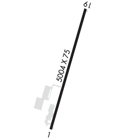
Runway Identifications
Runway Identification: 01/19
Length: 5004 ft
Width: 75 ft
Surface: ASPHALT
Edge lights: Medium Intensity

Treatment: NONE

 Runway: 01   Runway: 19
Mag heading: 12°Mag heading: 192°
Rwy Slope: -.32% DownRwy Slope: .32% Up
Approach: Approach:
Pattern: Left TrafficPattern: Left Traffic
Markings: NONPRECISION INSTRUMENTMarkings: NONPRECISION INSTRUMENT
Marking Condition: FAIRMarking Condition: FAIR
Arresting Dev: Arresting Dev:
Lat & Long: N3238.4  W09318.0Lat. & Long.: N3239.2  W09317.7
Elev: 277.6 ft. MSLElev: 261.8 ft. MSL
TCH: 53 ft. AGLTCH: 64 ft. AGL
Visual Glide Path: 3.15 degreesVisual Glide Path: 3.75 degrees
Displaced Threshold: NoDisplaced Threshold: No
Touchdown Zone: YESTouchdown Zone: YES
Touchdown Elev.: 278.4 feetTouchdown Elev.: 269.2 feet
Visual Glide Slope: 2-Light PAPI on LEFT side of RunwayVisual Glide Slope: 2-Light PAPI on LEFT side of Runway
RVR Equipment: RVR Equipment:
RVV Equipment: NORVV Equipment: NO
Approach Lights: Approach Lights:
REIL: YESREIL: YES
Centerline Lights: NOCenterline Lights: NO
Touchdown lights: NOTouchdown lights: NO
Runway Category: Runway with a Non-precision Approach having visibility minimums greater than 3/4 mileRunway Category: Runway with a Non-precision Approach having visibility minimums greater than 3/4 mile
Declared Distances: Declared Distances:
Obstructions: TREESObstructions: TREES
Marked: NOT Marked/LightedMarked: NOT Marked/Lighted
Clearance slope: 26:1Clearance slope: 3:1
Obstruction height: 53 feet AGLObstruction height: 28 feet AGL
Dist. from runway: 1583 feetDist. from runway: 291 feet
Centerline offset: 317 right of centerlineCenterline offset: 127 feet right of centerline
Comments: Comments:
C:3/P: