KMMU

Whisper PlateWhisper Track
MORRISTOWN MUNICIPAL AIRPORT
MORRISTOWN
NJ
Time Zone: Eastern
Lat: N 4048.0
Long: W 07424.9
Elev: 187
Var: +13
Longest Runway: 5998
Clr Del: 128.6
Dept. ATIS: 124.25
Arr. ATIS: 124.25
Ground: 134.2
CTAF: 118.1

FBO & Flight Services info for KMMU

FBOs: Update your Fuel Prices
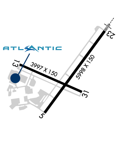
Atlantic Aviation is your premier aviation service provider with more than 100 locations in North America, including Hawaii and the Caribbean. We provide standard ground services you'd expect, with a detailed focus on ensuring an unforgettable customer experience.
Ph: 973-401-1900 Fax: 973-401-1700 Freq: 131.57WebsiteE-Mail
Service
Jet
100LL
SAF
MoGas
Fuel Avail: PRIST+$0.09/gal FBO Hours: Mon-Sun 24 hrs.
Full7.547.67    Last Update: 04/25/2024 13:10:33
PRICES GUARANTEED by FBO.
Self        
Misc. Info: Address: 50 AIRPORT ROAD   MORRISTOWN, NJ 07960

SIGNATUREPh: 973-292-1300 Fax: 973-292-2331 Freq: 129.6
Service
Jet
100LL
SAF
MoGas
Fuel Avail: PRIST+$0.06/gal. AVGAS discounts on Weekends.
Full7.648.97    Last Update: 04/25/2024 09:46  
Self        
 Address: 1 AIRPORT ROAD   MORRISTOWN, NJ 07960
If you are an FBO, call 1-203-262-1700 to update your info or email: FltPlan.Advertising@garmin.com
Advertise your FBO on FltPlan.com

Runway & Approach Info for KMMU
Rwy
Length
Land Dist**
Approach*
  Rwy
Length
Land Dist**
Approach*
05
5998x150  5998'          
 
  
23
  5998x150  5998'          
ILS
 110.30 - 229°  
13
3997x150  3997'          
 
  
31
  3997x150  3997'          
 
 * only ILS, LOC, LDA, and SDF approaches to a specific runway are shown
** For any Declared Landing Distance Available, please see A/FD or Approach plates
Runway Weight Capability (lbs.) Help
Runway IDSingle WheelDouble WheelDouble Tandem WheelDual Double Wheel
05/2330,00080,000N/AN/A
13/3130,000N/AN/AN/A
These numbers are Advisory and are not limits.   The Airport Manager should have more accurate Weight Limits
Approach Charts
Approaches    
Current Weather/Notams
7200' Runway  200-1/2 ILS
Customs Information Send updates to Support@FltPlan.com
Phone 973-267-0302
Fax 973-267-1759

Comments 4 hrs advance notice required. Business hrs 0800-1600 Monday-Friday. *Maximum passengers per flight: 20 **Call prior to 1300 on preceding weekday.
Database effective 05/16/2024
Airport Diagram of KMMU
Airport Diagram might not be current.

Facility Name: MORRISTOWN MUNI
City Name: MORRISTOWN
County: MORRIS
State abbrev: NJ
State Name: NEW JERSEY
   
Ownership: PUBLICLY OWNED
Use: OPEN TO THE PUBLIC
Owner's Name: TOWN OF MORRISTOWN
Address: 110 SOUTH STREET
 MORRISTOWN, NJ 07960
Owner's Phone: 973-292-6626
  
Manager's Name: SCOTT MCMAHON
Address: DM AIRPORTS, LTD., 8 AIRPORT ROAD
 MORRISTOWN, NJ 07960
Phone: 973-538-6400
   
FAA Region: EASTERN
FAA Field Office: HAR


Sunrise / Sunset times for MORRISTOWN MUNI

DateSunriseSunset
04/24/24 Wednesday6:0519:47
04/25/24 Thursday6:0319:49
04/26/24 Friday6:0219:50
04/27/24 Saturday6:0019:51
04/28/24 Sunday5:5919:52
04/29/24 Monday5:5819:53
04/30/24 Tuesday5:5619:54
05/01/24 Wednesday5:5519:55
05/02/24 Thursday5:5419:56
05/03/24 Friday5:5319:57
05/04/24 Saturday5:5119:58
05/05/24 Sunday5:5019:59
05/06/24 Monday5:4920:00
05/07/24 Tuesday5:4820:01

Airport Facilities

Airport Attendance Schedule7 Days A Week 0645-2230
Airport Status OPERATIONAL (This Status can change at any time - please check NOTAMS)
Airport Lighting ScheduleDUSK-DAWN; ACTVT HIRL RWY 05/23, MIRL RW 13/31, REIL RWY 05 & 31, MALSR RWY 23 & PAPI RWY 31 - CTAF.
Airport Storage AvailableTie Downs, Hanger
Extra Services AvailableCharter, Flight Instruction, Aircraft Rental
Wind IndicatorYES - (lighted)
Control TowerYES
CTAF Frequency118.100; WHEN TWR CLSD ALL ACFT AND VEHICLES MUST STATE INTNS ON CTAF BFR OPS ON ANY RWY.
Unicom Frequency
Rotating Beacon ColorWG
Segmented CircleYES
Landing FeeYES

Airport Inspection Data

Airport InspectedSTATE - performed by STATE AERONAUTICAL PERSONNEL
Inspection Date08/18/2023

Airport Services

Type of Fuel AvailableGrade 100LL, JET A (freeze point -40C), JET A; -A O-128 AVOIL AVBL.
Airframe Repair ServiceNONE
Power Plant Repair ServiceNONE

Geographic Data

LatitudeN4048.0
LongitudeW07424.9 (ESTIMATED)
Arpt Elevation186ft (SURVEYED)
Magnetic Variation13W
3 miles Eof MORRISTOWN
Traffic Pattern AltitudeTPA 1013 LIGHT ACFT, 1513 HEAVY ACFT.
Sectional ChartNEW YORK

Aircraft Data

Operations (Reported)YearlyAvg. Daily
General Aviation Transient 52233143
General Aviation Local 45767125
Air Taxi 1285235
Commerical 60
Commuter 00
Military 810
Aircraft based on Field
General Aviation Singles 78
General Aviation Multi 16
Jet Aircraft 67
General Aviation Helicopters 7
Military Aircraft 0
Gliders 0
Ultralights 0

FAA Services

FSS on field NO
FSS tie-in MILLVILLE
FSS Phone 1-800-WX-BRIEF
Who issues Notams MMU
Notam D service at airport YES
ARTCC Name NEW YORK

Federal Status

Airport Certification
Aircraft Rescue & Firefighting IndexARFF SVCS AVBL 24 HRS DAILY. FOR ARFF SVCS WHEN ATCT CLSD CTC ARFF STATION; CTAF OR 973-455-1953.
Airport of EntryNo
Custom Landing RightsNo; US CUSTOMS USER FEE ARPT.
Joint Civil/MilitaryNo
Military Landing rightsYES

Federal Agreements

NATIONAL PLAN OF INTEGRATED AIRPORT SYSTEMS (NPIAS)
GRANT AGREEMENTS UNDER FAAP/ADAP/AIP
ASSURANCES PURSUANT TO TITLE VI, CIVIL RIGHTS ACT OF 1964
AGREEMENT UNDER DLAND OR DCLA HAS EXPIRED.

Remarks

BIRDS & DEER ON & INVOF ARPT.
ARFF SVCS AVBL 24 HRS DAILY. FOR ARFF SVCS WHEN ATCT CLSD CTC ARFF STATION; CTAF OR 973-455-1953.
ALL ARRIVAL/DEPARTURE ACFT FOLLOW MANUFACTURERS RECOMMENDED PROCEDURES FOR QUIET OPNS & MINIMUM NOISE.
ROUTE 80 VISUAL APCH PREFERRED FOR RY 23.
HELICOPTER OPNS OVER RESIDENTIAL AREAS BLO 1000 FT MSL SHOULD BE AVOIDED.
STAGE I DEPARTURE FEE 2300-0645.
DURG SNOW REMOVAL OPNS 15 MINUTE PRIOR NOTICE REQUIRED ON 118.1 & NO PRACTICE LOW APCHS OR TOUCH & GO LDGS.
INBOUND TFC REQUEST FBO SVCS, INSTRUCTIONS & RAMP ADVISORIES 30 MINUTES PRIOR TO ARRIVAL. AFTER LDG CTC FBO AGAIN 129.6 FOR PREFERRED RAMP ENTRANCE TO DELTA OR JULIET TWYS.
TAXILANE K N OF LYNX FBO RAMP, NO HEL OR ACFT WITH A WINGSPAN GTR THAN 50 FT.
VOLUNTARY NOISE ABATEMENT PROC INCLUDE AVOIDING TGL OPS ON RWY 13-31.
NOISE ABATEMENT PROC IN EFCT; CTC NOISE ABATEMENT OFFICE 973-538-3366 EXTN 122.
FOR CD WHEN ATCT IS CLSD CTC NEW YORK APCH AT 800-645-3206.
NO TGL ON RWY 13/31 UNLESS THE CROSSWIND VLCTY FOR RWY 05/23 EXCEEDS 10 KTS.
US CUSTOMS AVBL MON-FRI 0800-1600; BTN 1601-0759 & WKENDS CALL 973-267-0302 FOR APPOINTMENT. MORRISTOWN CUSTOMS ASSOCIATION FEES APPLY; CTC AMGR 973-538-6400 FOR DETAILS.
NO TURBOJET LNDG ON RWY 13 & 31 UNLESS THE X-WIND VELOCITY FOR RWY 5/23 EXCEEDS 16 KNOTS.
ACFT CARRYING EXPLOSIVE CARGO PPR BEFORE LDG - CALL 973-538-6400.
FLIGHT NOTIFICATION SVC (ADCUS) AVBL.
U.S. CUSTOMS USER FEE ARPT.
Airport Communications & Frequencies:
ATIS Frequencies:   Hours(local) of Operation: CONTINUOUS
124.25
MORRISTOWN Tower Frequencies:   Hours(local) of operation: 0645-2230   
118.1
353.9
MORRISTOWN Ground Frequencies:
134.2
Clearance Delivery Frequencies:
128.6
Emergency Frequencies:
121.5
243.0
CTAF Frequency:
118.100; WHEN TWR CLSD ALL ACFT AND VEHICLES MUST STATE INTNS ON CTAF BFR OPS ON ANY RWY.
Remarks
  • CALL 516-542-3690 WHEN TWR CLSD.
  • NEW YORK Primary Approach Frequencies:  
    127.6
    379.9
    NEW YORK Primary Departure Frequencies:  
    119.2
    379.9
    Runway Identifications
    Runway Identification: 05/23
    Length: 5998 ft
    Width: 150 ft
    Surface: ASPHALT-GOOD CONDITION
    Edge lights: High Intensity

    Treatment: GROOVED
    Weight: PCN 25 /F/C/X/T

     Runway: 05   Runway: 23
    Mag heading: 49°Mag heading: 229°
    Rwy Slope: .02% UpRwy Slope: -.02% Down
    Approach: Approach: ILS
    Pattern: Left TrafficPattern: Left Traffic
    Markings: PRECISION INSTRUMENTMarkings: PRECISION INSTRUMENT
    Marking Condition: GOODMarking Condition: GOOD
    Arresting Dev: Arresting Dev:
    Lat & Long: N4047.6  W07425.2Lat. & Long.: N4048.4  W07424.4
    Elev: 181.8 ft. MSLElev: 182.8 ft. MSL
    TCH: TCH:
    Visual Glide Path: Visual Glide Path:
    Displaced Threshold: NoDisplaced Threshold: No
    Touchdown Zone: YESTouchdown Zone: YES
    Touchdown Elev.: 184.6 feetTouchdown Elev.: 183.8 feet
    Visual Glide Slope: Visual Glide Slope:
    RVR Equipment: RVR Equipment:
    RVV Equipment: NORVV Equipment: NO
    Approach Lights: Approach Lights: MALSR - 1,400 foot medium intensity approach lighting system with runway alignment indicator lights
    REIL: YESREIL: NO
    Centerline Lights: NOCenterline Lights: NO
    Touchdown lights: NOTouchdown lights: NO
    Runway Category: Runway with a Non-precision Approach having visibility minimums greater than 3/4 mileRunway Category: Precision Instrument Runway
    Declared Distances: Declared Distances:
    Obstructions: TREESObstructions:
    Marked: NOT Marked/LightedMarked:
    Clearance slope: 18:1Clearance slope: 50:1
    Obstruction height: 102 feet AGLObstruction height:
    Dist. from runway: 2100 feetDist. from runway:
    Centerline offset: Centerline offset:
    Comments: Comments:
    Runway Identification: 13/31
    Length: 3997 ft
    Width: 150 ft
    Surface: ASPHALT-GOOD CONDITION
    Edge lights: Medium Intensity

    Treatment: GROOVED
    Weight: PCN 11 /F/C/X/T

     Runway: 13   Runway: 31
    Mag heading: 127°Mag heading: 307°
    Rwy Slope: -.13% DownRwy Slope: .13% Up
    Approach: Approach:
    Pattern: Left TrafficPattern: Left Traffic
    Markings: BASICMarkings: BASIC
    Marking Condition: GOODMarking Condition: GOOD
    Arresting Dev: Arresting Dev:
    Lat & Long: N4048.1  W07425.5Lat. & Long.: N4047.8  W07424.7
    Elev: 186.5 ft. MSLElev: 181.3 ft. MSL
    TCH: TCH: 39 ft. AGL
    Visual Glide Path: Visual Glide Path: 3.50 degrees
    Displaced Threshold: NoDisplaced Threshold: No
    Touchdown Zone: YESTouchdown Zone: YES
    Touchdown Elev.: 186.6 feetTouchdown Elev.: 183.9 feet
    Visual Glide Slope: Visual Glide Slope: 2-Light PAPI on LEFT side of Runway
    RVR Equipment: RVR Equipment:
    RVV Equipment: NORVV Equipment: NO
    Approach Lights: Approach Lights:
    REIL: NOREIL: YES
    Centerline Lights: NOCenterline Lights: NO
    Touchdown lights: NOTouchdown lights: NO
    Runway Category: Runway with a Visual ApproachRunway Category: Runway with a Visual Approach
    Declared Distances: Declared Distances:
    Obstructions: TREESObstructions: TREES
    Marked: NOT Marked/LightedMarked: NOT Marked/Lighted
    Clearance slope: 2:1Clearance slope: 16:1
    Obstruction height: 49 feet AGLObstruction height: 91 feet AGL
    Dist. from runway: 320 feetDist. from runway: 1690 feet
    Centerline offset: 240 right of centerlineCenterline offset: 330 feet left of centerline
    Comments: Comments:
    C:173/P: