Current Weather/Notams (Metars, TAFs, Notams, NWS Forecast, PIREPS, and nearby weather)
Customs Information Send updates to Support@FltPlan.com
Customs Not Available
Database effective 04/18/2024
Airport Diagram might not be current.
|
| Facility Name: | SELFS |
| City Name: | MARKS |
| County: | QUITMAN |
| State abbrev: | MS |
| State Name: | MISSISSIPPI |
| | |
| Ownership: | PUBLICLY OWNED |
| Use: | OPEN TO THE PUBLIC |
| Owner's Name: | QUITMAN COUNTY |
| Address: | 230 CHESTNUT ST |
| | MARKS, MS 38646 |
| Owner's Phone: | 662-326-3161 |
| | |
| Manager's Name: | KEVIN RUSHING |
| Address: | 733 AIRPORT RD, PO BOX 370 |
| | MARKS, MS 38646 |
| Phone: | 662-444-4736 |
| | |
| FAA Region: | SOUTHERN |
| FAA Field Office: | JAN |
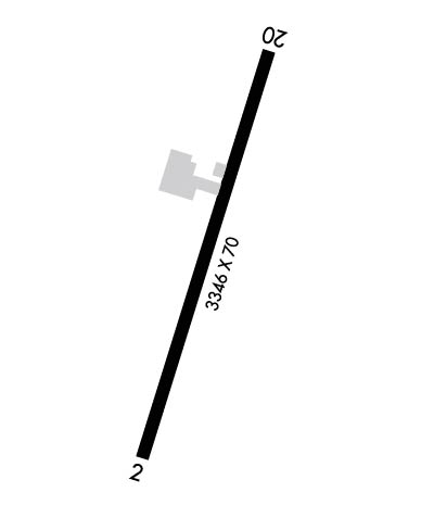
Runway Identifications
Runway Identification: 02/20Length: 3346 ft
Width: 70 ft
Surface: ASPHALT-FAIR CONDITION
Edge lights: Medium IntensityTreatment: NONE
| | Runway: 02 | | Runway: 20 |
| Mag heading: | 16° | Mag heading: | 196° |
| Rwy Slope: | -.01% Down | Rwy Slope: | .01% Up |
| Approach: | | Approach: | |
| Pattern: | Left Traffic | Pattern: | Left Traffic |
| Markings: | NONPRECISION INSTRUMENT | Markings: | NONPRECISION INSTRUMENT |
| Marking Condition: | POOR; MARKINGS BADLY FADED. | Marking Condition: | FAIR |
| Arresting Dev: | | Arresting Dev: | |
| Lat & Long: | N3413.6 W09017.5 | Lat. & Long.: | N3414.2 W09017.3 |
| Elev: | 160.8 ft. MSL | Elev: | 160.5 ft. MSL |
| TCH: | | TCH: | |
| Visual Glide Path: | | Visual Glide Path: | |
| Displaced Threshold: | No | Displaced Threshold: | No |
| Touchdown Zone: | YES | Touchdown Zone: | YES |
| Touchdown Elev.: | 161.7 feet | Touchdown Elev.: | 161.7 feet |
| Visual Glide Slope: | | Visual Glide Slope: | |
| RVR Equipment: | | RVR Equipment: | |
| RVV Equipment: | NO | RVV Equipment: | NO |
| Approach Lights: | | Approach Lights: | |
| REIL: | NO | REIL: | NO |
| Centerline Lights: | NO | Centerline Lights: | NO |
| Touchdown lights: | NO | Touchdown lights: | NO |
| Runway Category: | Runway with a Non-precision Approach | Runway Category: | Runway with a Non-precision Approach |
| Declared Distances: | | Declared Distances: | |
| Obstructions: | | Obstructions: | TREES |
| Marked: | | Marked: | NOT Marked/Lighted |
| Clearance slope: | 50:1 | Clearance slope: | 20:1 |
| Obstruction height: | | Obstruction height: | 71 feet AGL |
| Dist. from runway: | | Dist. from runway: | 1750 feet |
| Centerline offset: | | Centerline offset: | 300 feet right of centerline |
| Comments: | | Comments: | PAVED RD 160 FT FM THR. |

