
| ||||||||||||||||||||||||||||||||||||||||||||
| ||||||||||||||||||||||||||||||||||||||||||||
| ||||||||||||||||||||||||||||||||||||||||||||
| Rwy | Rwy | |||||||
| 3100x75 | 3100' | 3100x75 | 3100' | |||||
| Runway ID | Single Wheel | Double Wheel | Double Tandem Wheel | Dual Double Wheel |
| 18/36 | 30,000 | N/A | N/A | N/A |
| These numbers are Advisory and are not limits. The Airport Manager should have more accurate Weight Limits | ||||
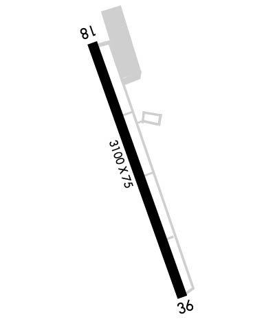 Airport Diagram might not be current. | |
| Facility Name: | MERIDEN MARKHAM MUNI |
| City Name: | MERIDEN |
| County: | NEW HAVEN |
| State abbrev: | CT |
| State Name: | CONNECTICUT |
| Ownership: | PUBLICLY OWNED |
| Use: | OPEN TO THE PUBLIC |
| Owner's Name: | CITY OF MERIDEN |
| Address: | CITY MANAGER, CITY HALL, 142 E MAIN ST |
| MERIDEN, CT 06450 | |
| Owner's Phone: | (203) 630-4115 |
| Manager's Name: | CONSTANCE CASTILLO |
| Address: | 213 EVANSVILLE AVENUE |
| MERIDEN, CT 06451 | |
| Phone: | 203-630-2878 |
| FAA Region: | NEW ENGLAND |
| FAA Field Office: | NONE |
| Date | Sunrise | Sunset |
|---|---|---|
| 04/25/24 Thursday | 5:56 | 19:43 |
| 04/26/24 Friday | 5:54 | 19:45 |
| 04/27/24 Saturday | 5:53 | 19:46 |
| 04/28/24 Sunday | 5:51 | 19:47 |
| 04/29/24 Monday | 5:50 | 19:48 |
| 04/30/24 Tuesday | 5:49 | 19:49 |
| 05/01/24 Wednesday | 5:47 | 19:50 |
| 05/02/24 Thursday | 5:46 | 19:51 |
| 05/03/24 Friday | 5:45 | 19:52 |
| 05/04/24 Saturday | 5:44 | 19:53 |
| 05/05/24 Sunday | 5:42 | 19:54 |
| 05/06/24 Monday | 5:41 | 19:55 |
| 05/07/24 Tuesday | 5:40 | 19:56 |
| 05/08/24 Wednesday | 5:39 | 19:57 |
| Airport Attendance Schedule | MON-SUN 0900-1700 |
| Airport Status | OPERATIONAL (This Status can change at any time - please check NOTAMS) |
| Airport Lighting Schedule | ACTVT REIL RWY 36; MIRL RWY 18/36 - CTAF. |
| Airport Storage Available | Tie Downs |
| Extra Services Available | Charter, Flight Instruction, Aircraft Rental, Aircraft Sales |
| Wind Indicator | YES - (lighted) |
| Control Tower | NO |
| CTAF Frequency | 123.050 |
| Unicom Frequency | 123.050 |
| Rotating Beacon Color | WG |
| Segmented Circle | YES |
| Landing Fee | NO |
| Airport Inspected | STATE - performed by PRIVATE CONTRACT PERSONNEL |
| Inspection Date | 08/22/2022 |
| Type of Fuel Available | Grade 100LL; -10SELF SVC FUEL. |
| Airframe Repair Service | MAJOR |
| Power Plant Repair Service | MAJOR |
| Latitude | N4130.5 |
| Longitude | W07249.8 (ESTIMATED) |
| Arpt Elevation | 103ft (SURVEYED) |
| Magnetic Variation | 14W |
| 3 miles SW | of MERIDEN |
| Traffic Pattern Altitude | |
| Sectional Chart | NEW YORK |
| Operations (Reported) | Yearly | Avg. Daily |
|---|---|---|
| General Aviation Transient | 23486 | 64 |
| General Aviation Local | 28494 | 78 |
| Air Taxi | 1760 | 5 |
| Commerical | 0 | 0 |
| Commuter | 0 | 0 |
| Military | 83 | 0 |
| Aircraft based on Field | |
|---|---|
| General Aviation Singles | 45 |
| General Aviation Multi | 0 |
| Jet Aircraft | 0 |
| General Aviation Helicopters | 0 |
| Military Aircraft | 0 |
| Gliders | 0 |
| Ultralights | 0 |
| FSS on field | NO |
| FSS tie-in | BRIDGEPORT |
| FSS Phone | 1-800-WX-BRIEF |
| Who issues Notams | MMK |
| Notam D service at airport | YES |
| ARTCC Name | BOSTON |
| Airport Certification | |
| Aircraft Rescue & Firefighting Index | None |
| Airport of Entry | No |
| Custom Landing Rights | No |
| Joint Civil/Military | No |
| Military Landing rights | No |
| NATIONAL PLAN OF INTEGRATED AIRPORT SYSTEMS (NPIAS) |
| GRANT AGREEMENTS UNDER FAAP/ADAP/AIP |
| ASSURANCES PURSUANT TO TITLE VI, CIVIL RIGHTS ACT OF 1964 |
| THIS AIRPORT HAS BEEN SURVEYED BY THE NATIONAL GEODETIC SURVEY. |
| RWY 36 NO TGLS. |
| CRANES 150 FT AGL, 0.25 MI NW AER 18, LGTD. OPER INTMT DALGT HRS. |
| PPR FOR JET ACFT. |
| CALM WIND RWY 18. |
| STD LEFT TFC, BOTH RWYS. |
| FOR CD CTC YANKEE APCH AT 860-386-3597. |
| CTN DEER, COYOTES & BIRDS ON & INVOF ARPT. |
Airport Communications & Frequencies:
| ||||||||||||||||
| Runway: 18 | Runway: 36 | ||
| Mag heading: | 176° | Mag heading: | 356° |
| Rwy Slope: | -.14% Down | Rwy Slope: | .14% Up |
| Approach: | Approach: | ||
| Pattern: | Left Traffic | Pattern: | Left Traffic |
| Markings: | NONPRECISION INSTRUMENT | Markings: | NONPRECISION INSTRUMENT |
| Marking Condition: | GOOD | Marking Condition: | GOOD |
| Arresting Dev: | Arresting Dev: | ||
| Lat & Long: | N4130.8 W07249.9 | Lat. & Long.: | N4130.3 W07249.7 |
| Elev: | 103.0 ft. MSL | Elev: | 98.6 ft. MSL |
| TCH: | TCH: | 38 ft. AGL | |
| Visual Glide Path: | Visual Glide Path: | 3.50 degrees | |
| Displaced Threshold: | No | Displaced Threshold: | No |
| Touchdown Zone: | YES | Touchdown Zone: | YES |
| Touchdown Elev.: | 103.0 feet | Touchdown Elev.: | 98.6 feet |
| Visual Glide Slope: | Visual Glide Slope: | 4-Light PAPI on LEFT side of Runway | |
| RVR Equipment: | RVR Equipment: | ||
| RVV Equipment: | NO | RVV Equipment: | NO |
| Approach Lights: | Approach Lights: | ||
| REIL: | NO | REIL: | YES |
| Centerline Lights: | NO | Centerline Lights: | NO |
| Touchdown lights: | NO | Touchdown lights: | NO |
| Runway Category: | Runway with a Visual Approach | Runway Category: | Runway with a Non-precision Approach |
| Declared Distances: | Declared Distances: | ||
| Obstructions: | TREE | Obstructions: | TREE |
| Marked: | NOT Marked/Lighted | Marked: | MARKED and LIGHTED |
| Clearance slope: | 8:1 | Clearance slope: | 10:1 |
| Obstruction height: | 60 feet AGL | Obstruction height: | 75 feet AGL |
| Dist. from runway: | 700 feet | Dist. from runway: | 975 feet |
| Centerline offset: | 250 left of centerline | Centerline offset: | 305 feet right of centerline |
| Comments: | 5 FT BRUSH, 0 FT DSTC, 161 FT R, 8 FT BR, 190 FT DSTC. | Comments: |
