
| ||||||||||||||||||||||||||||||||||||||||||||
| ||||||||||||||||||||||||||||||||||||||||||||
| ||||||||||||||||||||||||||||||||||||||||||||
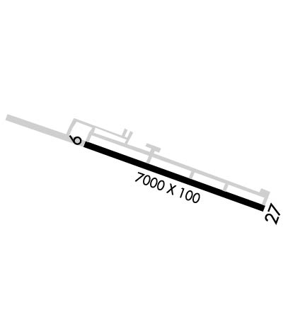
| Rwy | Rwy | |||||||
| 7000x100 | 7000' | 7000x100 | 7000' | |||||
| Runway ID | Single Wheel | Double Wheel | Double Tandem Wheel | Dual Double Wheel |
| 09/27 | 85,000 | 150,000 | N/A | N/A |
| These numbers are Advisory and are not limits. The Airport Manager should have more accurate Weight Limits | ||||
 Airport Diagram might not be current. | |
| Facility Name: | MAMMOTH YOSEMITE |
| City Name: | MAMMOTH LAKES |
| County: | MONO |
| State abbrev: | CA |
| State Name: | CALIFORNIA |
| Ownership: | PUBLICLY OWNED |
| Use: | OPEN TO THE PUBLIC |
| Owner's Name: | TOWN OF MAMMOTH LAKES |
| Address: | 1300 AIRPORT ROAD |
| MAMMOTH LAKES, CA 93546 | |
| Owner's Phone: | 760-934-3813 |
| Manager's Name: | SIERRA SHULTZ |
| Address: | PO BOX 1609 |
| MAMMOTH LAKES, CA 93546 | |
| Phone: | 760-914-3130 |
| FAA Region: | WESTERN-PACIFIC |
| FAA Field Office: | SFO |

| Date | Sunrise | Sunset |
|---|---|---|
| 04/18/24 Thursday | 6:15 | 19:34 |
| 04/19/24 Friday | 6:14 | 19:35 |
| 04/20/24 Saturday | 6:12 | 19:36 |
| 04/21/24 Sunday | 6:11 | 19:37 |
| 04/22/24 Monday | 6:10 | 19:38 |
| 04/23/24 Tuesday | 6:09 | 19:39 |
| 04/24/24 Wednesday | 6:07 | 19:40 |
| 04/25/24 Thursday | 6:06 | 19:41 |
| 04/26/24 Friday | 6:05 | 19:42 |
| 04/27/24 Saturday | 6:04 | 19:43 |
| 04/28/24 Sunday | 6:02 | 19:44 |
| 04/29/24 Monday | 6:01 | 19:44 |
| 04/30/24 Tuesday | 6:00 | 19:45 |
| 05/01/24 Wednesday | 5:59 | 19:46 |
| Airport Attendance Schedule | 7 Days A Week 0800-1630 |
| Airport Status | OPERATIONAL (This Status can change at any time - please check NOTAMS) |
| Airport Lighting Schedule | ACTVT REIL RWY 27; MIRL RWY 09/27 - CTAF. |
| Airport Storage Available | Tie Downs, Hanger |
| Extra Services Available | NONE |
| Wind Indicator | YES - (unlit) |
| Control Tower | NO |
| CTAF Frequency | 122.800 |
| Unicom Frequency | 122.800 |
| Rotating Beacon Color | WG |
| Segmented Circle | YES |
| Landing Fee | YES |
| Airport Inspected | FEDERAL - performed by FAA AIRPORTS FIELD PERSONNEL |
| Inspection Date | 08/25/2023 |
| Type of Fuel Available | Grade 100LL, JET A (freeze point -40C); -10100LL FUEL AVBL 24 HRS; CARD LOCK SYSTEM. |
| Airframe Repair Service | NONE |
| Power Plant Repair Service | NONE |
| Latitude | N3737.4 |
| Longitude | W11850.3 (ESTIMATED) |
| Arpt Elevation | 7134ft (SURVEYED) |
| Magnetic Variation | 15E |
| 6 miles E | of MAMMOTH LAKES |
| Traffic Pattern Altitude | 872 |
| Sectional Chart | SAN FRANCISCO |
| Operations (Reported) | Yearly | Avg. Daily |
|---|---|---|
| General Aviation Transient | 2269 | 6 |
| General Aviation Local | 1320 | 4 |
| Air Taxi | 3043 | 8 |
| Commerical | 0 | 0 |
| Commuter | 0 | 0 |
| Military | 112 | 0 |
| Aircraft based on Field | |
|---|---|
| General Aviation Singles | 12 |
| General Aviation Multi | 2 |
| Jet Aircraft | 0 |
| General Aviation Helicopters | 1 |
| Military Aircraft | 0 |
| Gliders | 0 |
| Ultralights | 0 |
| FSS on field | NO |
| FSS tie-in | RIVERSIDE |
| FSS Phone | 1-800-WX-BRIEF |
| Who issues Notams | MMH |
| Notam D service at airport | YES |
| ARTCC Name | OAKLAND |
| Airport Certification | AIRPORT RECEIVING SCHEDULED AIR CARRIER SERVICE FROM CARRIERS CERTIFICATED BY THE CIVIL AERONAUTICS BOARD; CLSD TO ACR OPNS OF CHTR OPNS, BUS JET OPNS, AND SKEDD COML OPNS OF ACR WITH MORE THAN 30 PSGRS AND/OR WINGSPANS GTR THAN 79 FEET EXCP 24 HR PPR. CALL AMGR 760-965-3654. |
| Aircraft Rescue & Firefighting Index | AIRPORT HAS A CERTIFICATE UNDER CFR PART 139 |
| Airport of Entry | No |
| Custom Landing Rights | No |
| Joint Civil/Military | No |
| Military Landing rights | YES |
| NATIONAL PLAN OF INTEGRATED AIRPORT SYSTEMS (NPIAS) |
| GRANT AGREEMENTS UNDER FAAP/ADAP/AIP |
| ASSURANCES PURSUANT TO TITLE VI, CIVIL RIGHTS ACT OF 1964 |
| RIDGE 3 NM FM APCH END RWY 09. |
| APCH REF CODE B/III/5000, DEP REF CODE B/III. |
| FOR CD IF UNA TO CTC ON FSS FREQ, CTC OAKLAND ARTCC AT 510-745-3380. |
| RIDGE AT RWY 27 IS 304 FT ABOVE RWY & 1200 FT NORTH OF CNTRLN WITH HAZARD BEACONS. |
| ARPT LCTD IN MOUNTAINOUS TERRAIN WITH OCNL STRONG WINDS AND TURBULENCE. LGTD WINDSOCK AVBL AT RY ENDS AND CENTERFIELD; WITH SOUTHERLY CROSSWINDS IN EXCESS OF 15 KNOTS; EXPC TURBULENCE AND PSBL WINDSHEAR ALONG FIRST 3000 FT OF RY 27. |
| NIGHT FLYING NOT RECOMMENDED WITHOUT KNOWLEDGE OF LOCAL TERRAIN. |
| NOISE ABATEMENT: ACFT ARR FM THE SOUTH, OR DEP TO THE SOUTH REMAIN EAST OF HWY 395. |
| NO SNOW REMOVAL DRG NGT HRS (1630-0700L) WO PRIOR PMSN. |
| 33 FT POLE LCTD 400 FT WEST OF APCH END OF RY 27 AND 375 FT SOUTH OF RY 27 CENTERLINE MARKED WITH OBSTRUCTION LIGHT. |
| LDG FEES. |
Airport Communications & Frequencies:
| |||||||||
| Runway: 09 | Runway: 27 | ||
| Mag heading: | 94° | Mag heading: | 274° |
| Rwy Slope: | -1.05% Down | Rwy Slope: | 1.05% Up |
| Approach: | Approach: | ||
| Pattern: | Left Traffic | Pattern: | Right Traffic |
| Markings: | NONPRECISION INSTRUMENT | Markings: | NONPRECISION INSTRUMENT |
| Marking Condition: | GOOD | Marking Condition: | GOOD |
| Arresting Dev: | Arresting Dev: | ||
| Lat & Long: | N3737.6 W11851.0 | Lat. & Long.: | N3737.3 W11849.6 |
| Elev: | 7134.8 ft. MSL | Elev: | 7061.4 ft. MSL |
| TCH: | TCH: | 45 ft. AGL | |
| Visual Glide Path: | Visual Glide Path: | 3.00 degrees | |
| Displaced Threshold: | No | Displaced Threshold: | No |
| Touchdown Zone: | YES | Touchdown Zone: | YES |
| Touchdown Elev.: | 7134.8 feet | Touchdown Elev.: | 7097.4 feet |
| Visual Glide Slope: | Visual Glide Slope: | 4-Light PAPI on LEFT side of Runway | |
| RVR Equipment: | RVR Equipment: | ||
| RVV Equipment: | NO | RVV Equipment: | NO |
| Approach Lights: | Approach Lights: | ||
| REIL: | NO | REIL: | YES |
| Centerline Lights: | NO | Centerline Lights: | NO |
| Touchdown lights: | NO | Touchdown lights: | NO |
| Runway Category: | Runway with a Visual Approach | Runway Category: | Runway with a Non-precision Approach having visibility minimums greater than 3/4 mile |
| Declared Distances: | TORA:7000' TODA:7000' ASDA:7000' LDA:7000' | Declared Distances: | TORA:7000' TODA:7000' ASDA:7000' LDA:7000' |