| |||||||||||||||||||||||||||||||||||||||||||||||||||||||||||||||||||||
| |||||||||||||||||||||||||||||||||||||||||||||||||||||||||||||||||||||
| |||||||||||||||||||||||||||||||||||||||||||||||||||||||||||||||||||||
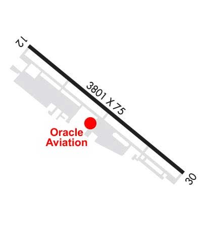
| Rwy | Rwy | |||||||
| 3801x75 | 3589' | 3801x75 | 3801' | |||||
| Runway ID | Single Wheel | Double Wheel | Double Tandem Wheel | Dual Double Wheel |
| 12/30 | 25,000 | 28,000 | N/A | N/A |
| These numbers are Advisory and are not limits. The Airport Manager should have more accurate Weight Limits | ||||
 Airport Diagram might not be current. | |
| Facility Name: | MILLARD |
| City Name: | OMAHA |
| County: | DOUGLAS |
| State abbrev: | NE |
| State Name: | NEBRASKA |
| Ownership: | PUBLICLY OWNED |
| Use: | OPEN TO THE PUBLIC |
| Owner's Name: | OMAHA AIRPORT AUTHORITY |
| Address: | 4501 ABBOTT DRIVE, SUITE 2300 |
| OMAHA, NE 68110-2689 | |
| Owner's Phone: | 402-661-8000 |
| Manager's Name: | DAVID ROTH |
| Address: | 4501 ABBOTT DRIVE, SUITE 2300 |
| OMAHA, NE 68110-2689 | |
| Phone: | 402-661-8000 |
| FAA Region: | CENTRAL |
| FAA Field Office: | NONE |

| Date | Sunrise | Sunset |
|---|---|---|
| 04/18/24 Thursday | 6:39 | 20:09 |
| 04/19/24 Friday | 6:38 | 20:10 |
| 04/20/24 Saturday | 6:36 | 20:11 |
| 04/21/24 Sunday | 6:35 | 20:12 |
| 04/22/24 Monday | 6:33 | 20:13 |
| 04/23/24 Tuesday | 6:32 | 20:14 |
| 04/24/24 Wednesday | 6:31 | 20:15 |
| 04/25/24 Thursday | 6:29 | 20:16 |
| 04/26/24 Friday | 6:28 | 20:17 |
| 04/27/24 Saturday | 6:26 | 20:18 |
| 04/28/24 Sunday | 6:25 | 20:19 |
| 04/29/24 Monday | 6:24 | 20:20 |
| 04/30/24 Tuesday | 6:22 | 20:21 |
| 05/01/24 Wednesday | 6:21 | 20:22 |
| Airport Attendance Schedule | 7 Days A Week 0630-2100; FOR SVC AFT 2100 CALL 402-953-9905 OR 402-690-3099. |
| Airport Status | OPERATIONAL (This Status can change at any time - please check NOTAMS) |
| Airport Lighting Schedule | ACTVT MIRL RY 12/30 & REIL RY 12 - CTAF. |
| Airport Storage Available | Tie Downs, Hanger |
| Extra Services Available | Air Ambulance, Charter, Flight Instruction, Aircraft Rental, Aircraft Sales |
| Wind Indicator | YES - (lighted) |
| Control Tower | NO |
| CTAF Frequency | 123.000 |
| Unicom Frequency | 123.000 |
| Rotating Beacon Color | WG |
| Segmented Circle | NO |
| Landing Fee | NO |
| Airport Inspected | STATE - performed by STATE AERONAUTICAL PERSONNEL |
| Inspection Date | 08/25/2021 |
| Type of Fuel Available | Grade 100LL, JET A-1 (icing inhibitor, freeze point -50C) |
| Airframe Repair Service | MAJOR |
| Power Plant Repair Service | MAJOR |
| Latitude | N4111.8 |
| Longitude | W09606.7 (ESTIMATED) |
| Arpt Elevation | 1050ft (SURVEYED) |
| Magnetic Variation | 06E |
| 7 miles SW | of OMAHA |
| Traffic Pattern Altitude | |
| Sectional Chart | OMAHA |
| Operations (Reported) | Yearly | Avg. Daily |
|---|---|---|
| General Aviation Transient | 14150 | 39 |
| General Aviation Local | 8400 | 23 |
| Air Taxi | 1375 | 4 |
| Commerical | 0 | 0 |
| Commuter | 0 | 0 |
| Military | 75 | 0 |
| Aircraft based on Field | |
|---|---|
| General Aviation Singles | 100 |
| General Aviation Multi | 8 |
| Jet Aircraft | 0 |
| General Aviation Helicopters | 1 |
| Military Aircraft | 0 |
| Gliders | 1 |
| Ultralights | 0 |
| FSS on field | NO |
| FSS tie-in | COLUMBUS |
| FSS Phone | 1-800-WX-BRIEF |
| Who issues Notams | MLE |
| Notam D service at airport | YES |
| ARTCC Name | MINNEAPOLIS |
| Airport Certification | |
| Aircraft Rescue & Firefighting Index | None |
| Airport of Entry | No |
| Custom Landing Rights | No |
| Joint Civil/Military | No |
| Military Landing rights | YES |
| NATIONAL PLAN OF INTEGRATED AIRPORT SYSTEMS (NPIAS) |
| GRANT AGREEMENTS UNDER FAAP/ADAP/AIP |
| ASSURANCES PURSUANT TO TITLE VI, CIVIL RIGHTS ACT OF 1964 |
| MIL JETS OVERFLYING AT 3000 FT MSL. |
| AFTER TKOF ON RY 30 ALTER HDG 20 DEGS TO THE R TO AVOID NOISE SENSITIVE AREA. |
| NORMAL CALM & CROSS WIND TKOFS & LNDGS OF RY 12; NO INTXN TKOFS. |
| RADIO CONTROLLED ACFT OCCASIONAL OPERATION 1.7 MI SW OF ARPT. |
| VFR ACFT REQUESTING FLIGHT FLWG & IFR ACFT SHOULD CONTACT OMAHA APCH ON FREQ 125.4 PRIOR TO TAKING THE RY FOR CLNC/TRAFFIC ADVISORIES/GEN INFO. |
| DEER ON & INVOF ARPT. |
| SELF-SVC FUEL AVBL 24 HRS WITH CREDIT CARD. |
Airport Communications & Frequencies:
| |||||||||||||||||||
| Runway: 12 | Runway: 30 | ||
| Mag heading: | 123° | Mag heading: | 303° |
| Rwy Slope: | -.12% Down | Rwy Slope: | .12% Up |
| Approach: | Approach: | ||
| Pattern: | Left Traffic | Pattern: | Left Traffic |
| Markings: | NONPRECISION INSTRUMENT | Markings: | NONPRECISION INSTRUMENT |
| Marking Condition: | GOOD | Marking Condition: | GOOD |
| Arresting Dev: | Arresting Dev: | ||
| Lat & Long: | N4112.0 W09607.1 | Lat. & Long.: | N4111.6 W09606.4 |
| Elev: | 1050.6 ft. MSL | Elev: | 1046.0 ft. MSL |
| TCH: | 42 ft. AGL | TCH: | 41 ft. AGL |
| Visual Glide Path: | 3.08 degrees | Visual Glide Path: | 3.08 degrees |
| Displaced Threshold: | 212 feet | Displaced Threshold: | No |
| Touchdown Zone: | YES | Touchdown Zone: | YES |
| Touchdown Elev.: | 1050.7 feet | Touchdown Elev.: | 1049.9 feet |
| Visual Glide Slope: | 2-Light PAPI on LEFT side of Runway | Visual Glide Slope: | 2-Light PAPI on LEFT side of Runway |
| RVR Equipment: | RVR Equipment: | ||
| RVV Equipment: | NO | RVV Equipment: | NO |
| Approach Lights: | Approach Lights: | ||
| REIL: | YES | REIL: | NO |
| Centerline Lights: | NO | Centerline Lights: | NO |
| Touchdown lights: | NO | Touchdown lights: | NO |
| Runway Category: | Runway with a Non-precision Approach | Runway Category: | Runway with a Non-precision Approach |
| Declared Distances: | TORA:3801' TODA:3801' ASDA:3801' LDA:3588' | Declared Distances: | TORA:3801' TODA:3801' ASDA:3588' LDA:3801' |
| Obstructions: | ROAD | Obstructions: | TREE |
| Marked: | NOT Marked/Lighted | Marked: | NOT Marked/Lighted |
| Clearance slope: | 12:1; APCH RATIO 36:1 FROM DSPLCD THR | Clearance slope: | 10:1 |
| Obstruction height: | 17 feet AGL | Obstruction height: | 57 feet AGL |
| Dist. from runway: | 410 feet | Dist. from runway: | 824 feet |
| Centerline offset: | 285 right of centerline | Centerline offset: | 269 feet right of centerline |
| Comments: | Comments: |