Click here for more info on on SMS!

KMLB

MELBOURNE INTL
MELBOURNE
FL
Time Zone: Eastern
Lat: N 2806.2
Long: W 08038.7
Elev: 33
Var: +07
Longest Runway: 10181
Clr Del: 132.65 TW CLD
Dept. ATIS: 132.55
Arr. ATIS: 132.55
Ground: 121.9
Tower: 118.2/124.05

FBO & Flight Services info for KMLB

FBOs: Update your Fuel Prices

  click here  
U.S. Customs, NATA Safety 1st Certified, CAA Preferred FBO, ample hangar and ramp space, superior ground support and concierge services, complimentary interior cleaning, catering, crew cars, canteen market and complimentary refreshments, executive conference room, pilot and passenger lounges.
Ph: 321-956-8695 Fax: 321-956-8696 Freq: 130.87WebsiteE-Mail
                     
Service
Jet
100LL
SAF
MoGas
Fuel Avail: Fully staffed 0600-2200, Afterhours available on request
Full6.537.80    Last Update: 04/23/2024 06:40
PRICES GUARANTEED by FBO.
Self        
Misc. Info: For purchases over 500 gallons of Jet A, call customer service for discounted price!Address: 140 S. APOLLO BLVD   MELBOURNE, FL 32901

SE AEROSPACE MROPh: 321-255-9877 Fax: 321-255-9608
-
Service
Jet
100LL
SAF
MoGas
Fuel Avail: ~~Aircraft Modifications, Repair, and Parts.
Full~~      Last Update: 04/24/2024 06:02:16  
Self        
F.I.T. AVIATIONPh: 321-674-6501 Fax: 321-674-6510 Freq: 122.95
Service
Jet
100LL
SAF
MoGas
Full  6.53    Last Update: 04/17/2024 08:55  
Self        
 Address: 801 HARRY GOODE WAY   MELBOURNE, FL 32901
ASOSPh: 321-723-7403
-
-
 
If you are an FBO, call 1-203-262-1700 to update your info or email: FltPlan.Advertising@garmin.com
Advertise your FBO on FltPlan.com
FBOs at nearby airports who want your business:
KVRB


  click here  
Welcome to Corporate Air Inc., a full service FBO in Vero Beach
- Luxurious state of the art FBO & ramp space to handle up to a Boeing Business Jet
- 70,000 sq ft of hangar space
- Maintenance, GPU, car rental, & NATA Safety First trained linemen
- (6 a.m. - 9 p.m) after hours avail
- CAA Preferred
- Jet A $6.38, 100LL $6.60 & Self-Serve $5.75
Ph: 1-772-562-1199WebsiteE-MailFax: 1-000-000-0000Freq: 122.77

Runway & Approach Info for KMLB
Rwy
Length
Land Dist**
Approach*
  Rwy
Length
Land Dist**
Approach*
05
3001x75  3001'          
 
  
23
  3001x75  3001'          
 
09L
6000x150  6000'          
 
  
27R
  6000x150  6000'          
 
09R
10181x150  10181'          
ILS
 108.30 - 093°  
  
27L
  10181x150  9482'          
 
 * only ILS, LOC, LDA, and SDF approaches to a specific runway are shown
** For any Declared Landing Distance Available, please see A/FD or Approach plates
Runway Weight Capability (lbs.) Help
Runway IDSingle WheelDouble WheelDouble Tandem WheelDual Double Wheel
05/2326,000N/AN/AN/A
09L/27R60,00060,000N/AN/A
09R/27L100,000165,000300,000N/A
These numbers are Advisory and are not limits.   The Airport Manager should have more accurate Weight Limits
Approach Charts
Approaches    
Current Weather/Notams
Customs Information Send updates to Support@FltPlan.com
Phone 321-674-5796
Fax 321-674-5797

Comments Mon-Fri 0830-1700 *2 hrs advance notice required *Prior approval required (landing rights and overflight). *Call prior to 1600 on preceding weekday. *Weekend arrivals call prior to 1600 on preceding Friday and after hours.
Database effective 05/16/2024
Airport Diagram of KMLB
Airport Diagram might not be current.

Facility Name: MELBOURNE ORLANDO INTL
City Name: MELBOURNE
County: BREVARD
State abbrev: FL
State Name: FLORIDA
   
Ownership: PUBLICLY OWNED
Use: OPEN TO THE PUBLIC
Owner's Name: CITY OF MELBOURNE
Address: 1 AIR TERMINAL PKWY/SUITE 220
 MELBOURNE, FL 32901
Owner's Phone: 321-723-6227
  
Manager's Name: GREG DONOVAN
Address: 1 AIRPORT TERMINAL PKWY, SUITE 220
 MELBOURNE, FL 32901
Phone: 321-723-6227
   
FAA Region: SOUTHERN
FAA Field Office: ORL


Sunrise / Sunset times for MELBOURNE ORLANDO INTL

DateSunriseSunset
04/23/24 Tuesday6:4919:53
04/24/24 Wednesday6:4819:54
04/25/24 Thursday6:4719:54
04/26/24 Friday6:4619:55
04/27/24 Saturday6:4519:55
04/28/24 Sunday6:4419:56
04/29/24 Monday6:4419:56
04/30/24 Tuesday6:4319:57
05/01/24 Wednesday6:4219:58
05/02/24 Thursday6:4119:58
05/03/24 Friday6:4019:59
05/04/24 Saturday6:4019:59
05/05/24 Sunday6:3920:00
05/06/24 Monday6:3820:01

Airport Facilities

Airport Attendance ScheduleCONTINUOUS
Airport Status OPERATIONAL (This Status can change at any time - please check NOTAMS)
Airport Lighting ScheduleWHEN ATCT CLSD ACTVT MALSR RWY 9R; REIL RWY 27L; PAPI RWY 9R & 27L; MIRL 5/23 & 9L/27R; HIRL RWY 9R/27L - CTAF.
Airport Storage AvailableTie Downs, Hanger
Extra Services AvailableAir Ambulance, Avionics, Cargo Handling, Charter, Flight Instruction, Aircraft Rental
Wind IndicatorYES - (lighted)
Control TowerYES
CTAF Frequency118.200
Unicom Frequency122.950
Rotating Beacon ColorWG
Segmented CircleYES
Landing FeeNO

Airport Inspection Data

Airport InspectedFEDERAL - performed by FAA AIRPORTS FIELD PERSONNEL
Inspection Date02/11/2020

Airport Services

Type of Fuel AvailableGrade 100LL, JET A (freeze point -40C)
Airframe Repair ServiceMAJOR
Power Plant Repair ServiceMAJOR

Geographic Data

LatitudeN2806.2
LongitudeW08038.7 (ESTIMATED)
Arpt Elevation33ft (SURVEYED)
Magnetic Variation07W
2 miles NWof MELBOURNE
Traffic Pattern Altitude
Sectional ChartJACKSONVILLE

Aircraft Data

Operations (Reported)YearlyAvg. Daily
General Aviation Transient 68586188
General Aviation Local 2768576
Air Taxi 25817
Commerical 421012
Commuter 00
Military 5982
Aircraft based on Field
General Aviation Singles 186
General Aviation Multi 42
Jet Aircraft 26
General Aviation Helicopters 9
Military Aircraft 1
Gliders 0
Ultralights 0

FAA Services

FSS on field NO
FSS tie-in SAINT PETERSBURG
FSS Phone 1-800-WX-BRIEF
Who issues Notams MLB
Notam D service at airport YES
ARTCC Name MIAMI

Federal Status

Airport CertificationAIRPORT RECEIVING SCHEDULED AIR CARRIER SERVICE FROM CARRIERS CERTIFICATED BY THE CIVIL AERONAUTICS BOARD; INDEX D AVBL UPON REQ.
Aircraft Rescue & Firefighting IndexAIRPORT HAS A CERTIFICATE UNDER CFR PART 139
Airport of EntryNo
Custom Landing RightsNo; US CUSTOMS USER FEE ARPT.
Joint Civil/MilitaryNo
Military Landing rightsYES

Federal Agreements

NATIONAL PLAN OF INTEGRATED AIRPORT SYSTEMS (NPIAS)
GRANT AGREEMENTS UNDER FAAP/ADAP/AIP
SURPLUS PROPERTY AGREEMENT UNDER PUBLIC LAW 289
SURPLUS PROPERTY AGREEMENT UNDER REGULATION 16-WAA
ASSURANCES PURSUANT TO TITLE VI, CIVIL RIGHTS ACT OF 1964
AGREEMENT UNDER DLAND OR DCLA HAS EXPIRED.

Remarks

TGL NA AFT 2100 OR 2 HR AFT SS; WHICHEVER IS LATER.
RSTRD: MIL AIRCREW USE OF NORTHROP/GRUMMAN RAMP PPR - GRUMMAN OPS DSN 854-5245 EXTN 5522, C407-5522; PRIOR TO ARR - GRUMMAN OPS 123.2.
UNCONTROLLED AREA TWY V WEST OF RWY 5; TWY C NORTH OF TWY K; TWY S NORTH OF S1; TWY H & G.
SFC COND NOT RPRTD 2300-0600.
BIRD ACT ON & INVOF ARPT.
CAUTION: RWY 9L/27R HLDG PSN SIGN ON TWY Q NOT STD; SIGN IS LCTD FWD OF RWY HLDG PSN MARKING.
RWY 05/2 3 RWY 5/23 NOT AVBL FOR SKED ACR OPNS WITH MORE THAN 9 PAX SEATS OR UNSKED ACR AT LEAST 31 PAX SEATS.
RWY 09R/ 27L400 FT BLAST PAD BOTH RWY ENDS.
Airport Communications & Frequencies:
ATIS Frequencies:   Hours(local) of Operation: CONTINUOUS
132.55
MELBOURNE Tower Frequencies:   Hours(local) of operation: 0600-2400   
118.2
124.05
257.8
MELBOURNE Ground Frequencies:
121.9
Clearance Delivery Frequencies:
121.9
132.65 WHEN MLB TWR CLSD
CTAF Frequency:
118.200
Unicom Frequency:
122.950
ORLANDO Primary Approach Frequencies:  
132.65
281.425
ORLANDO Primary Departure Frequencies:  
132.65
281.425
VFR Advisory Frequencies:
118.2
Runway Identifications
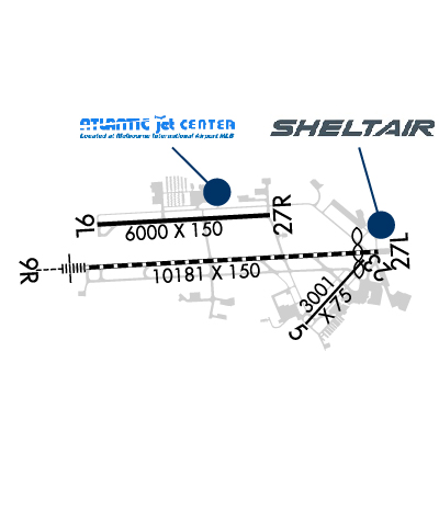
Runway Identification: 05/23
Length: 3001 ft
Width: 75 ft
Surface: ASPHALT
Edge lights: Medium Intensity

Treatment: NONE
Weight: PCN 9 /F/A/Y/T

 Runway: 05   Runway: 23
Mag heading: 49°Mag heading: 229°
Rwy Slope: -.12% DownRwy Slope: .12% Up
Approach: Approach:
Pattern: Left TrafficPattern: Left Traffic
Markings: BASICMarkings: BASIC
Marking Condition: GOODMarking Condition: GOOD
Arresting Dev: Arresting Dev:
Lat & Long: N2805.8  W08038.2Lat. & Long.: N2806.1  W08037.9
Elev: 25.1 ft. MSLElev: 21.5 ft. MSL
TCH: 21 ft. AGLTCH: 21 ft. AGL
Visual Glide Path: 3.00 degreesVisual Glide Path: 3.00 degrees
Displaced Threshold: NoDisplaced Threshold: No
Touchdown Zone: YESTouchdown Zone: YES
Touchdown Elev.: 25.2 feetTouchdown Elev.: 25.2 feet
Visual Glide Slope: 2-Light PAPI on LEFT side of RunwayVisual Glide Slope: 2-Light PAPI on LEFT side of Runway
RVR Equipment: RVR Equipment:
RVV Equipment: NORVV Equipment: NO
Approach Lights: Approach Lights:
REIL: NOREIL: NO
Centerline Lights: NOCenterline Lights: NO
Touchdown lights: NOTouchdown lights: NO
Runway Category: Runway with a Visual ApproachRunway Category: Runway with a Visual Approach
Declared Distances: TORA:3000' TODA:3000' ASDA:3000' LDA:3000'Declared Distances: TORA:3000' TODA:3000' ASDA:3000' LDA:3000'
Obstructions: TREESObstructions: HANGAR
Marked: NOT Marked/LightedMarked: LIGHTED
Clearance slope: 25:1Clearance slope: 26:1
Obstruction height: 41 feet AGLObstruction height: 45 feet AGL
Dist. from runway: 1240 feetDist. from runway: 1370 feet
Centerline offset: 135 right of centerlineCenterline offset: 65 feet right of centerline
Comments: Comments:
Runway Identification: 09L/27R
Length: 6000 ft
Width: 150 ft
Surface: ASPHALT
Edge lights: Medium Intensity

Treatment: GROOVED
Weight: PCN 31 /F/B/X/T

 Runway: 09L   Runway: 27R
Mag heading: 94°Mag heading: 274°
Rwy Slope: -.08% DownRwy Slope: .08% Up
Approach: Approach:
Pattern: Left TrafficPattern: Left Traffic
Markings: NONPRECISION INSTRUMENTMarkings: NONPRECISION INSTRUMENT
Marking Condition: GOODMarking Condition: GOOD
Arresting Dev: Arresting Dev:
Lat & Long: N2806.3  W08039.6Lat. & Long.: N2806.4  W08038.5
Elev: 30.5 ft. MSLElev: 26.0 ft. MSL
TCH: 39 ft. AGLTCH: 40 ft. AGL
Visual Glide Path: 3.00 degreesVisual Glide Path: 3.00 degrees
Displaced Threshold: NoDisplaced Threshold: No
Touchdown Zone: YESTouchdown Zone: YES
Touchdown Elev.: 33.3 feetTouchdown Elev.: 31.8 feet
Visual Glide Slope: 4-Light PAPI on LEFT side of RunwayVisual Glide Slope: 4-Light PAPI on LEFT side of Runway
RVR Equipment: RVR Equipment:
RVV Equipment: NORVV Equipment: NO
Approach Lights: Approach Lights:
REIL: NOREIL: NO
Centerline Lights: NOCenterline Lights: NO
Touchdown lights: NOTouchdown lights: NO
Runway Category: DRunway Category: D
Declared Distances: TORA:6000' TODA:6000' ASDA:6000' LDA:6000'Declared Distances: TORA:6000' TODA:6000' ASDA:6000' LDA:6000'
Obstructions: TREESObstructions: BLDG
Marked: NOT Marked/LightedMarked: MARKED and LIGHTED
Clearance slope: 13:1; RWY 09L APCH SLP 34:1 TO AER.Clearance slope: 36:1
Obstruction height: 26 feet AGLObstruction height: 46 feet AGL
Dist. from runway: 550 feetDist. from runway: 1880 feet
Centerline offset: 400 left of centerlineCenterline offset: 450 feet left of centerline
Comments: TREES 20 FT TALL, 200 FT BFR AER, 404 RIGHT OF CNTRLN.Comments:
Runway Identification: 09R/27L
Length: 10181 ft
Width: 150 ft
Surface: ASPHALT
Edge lights: High Intensity

Treatment: GROOVED
Weight: PCN 74 /F/A/X/T

 Runway: 09R   Runway: 27L
Mag heading: 94°Mag heading: 274°
Rwy Slope: -.10% DownRwy Slope: .10% Up
Approach: ILSApproach:
Pattern: Left TrafficPattern: Left Traffic
Markings: PRECISION INSTRUMENTMarkings: PRECISION INSTRUMENT
Marking Condition: GOODMarking Condition: GOOD
Arresting Dev: Arresting Dev:
Lat & Long: N2806.1  W08039.7Lat. & Long.: N2806.2  W08037.8
Elev: 32.0 ft. MSLElev: 21.4 ft. MSL
TCH: 83 ft. AGLTCH: 54 ft. AGL
Visual Glide Path: 3.00 degreesVisual Glide Path: 3.00 degrees
Displaced Threshold: NoDisplaced Threshold: 699 feet
Touchdown Zone: YESTouchdown Zone: YES
Touchdown Elev.: 32.1 feetTouchdown Elev.: 25.8 feet
Visual Glide Slope: 4-Light PAPI on LEFT side of RunwayVisual Glide Slope: 4-Light PAPI on LEFT side of Runway
RVR Equipment: TOUCHDOWN; RVR UNAVBL 0000-0600.RVR Equipment: ROLLOUT; RVR UNAVBL 0000-0600.
RVV Equipment: NORVV Equipment: NO
Approach Lights: MALSR - 1,400 foot medium intensity approach lighting system with runway alignment indicator lightsApproach Lights:
REIL: NOREIL: YES
Centerline Lights: YESCenterline Lights: YES
Touchdown lights: YESTouchdown lights: NO
Runway Category: Precision Instrument RunwayRunway Category: Runway with a Non-precision Approach having visibility minimums greater than 3/4 mile
Declared Distances: TORA:10181' TODA:10181' ASDA:10181' LDA:10181'Declared Distances: TORA:10181' TODA:10181' ASDA:10181' LDA:9482'
Obstructions: Obstructions: TREES
Marked: Marked: NOT Marked/Lighted
Clearance slope: 50:1Clearance slope: 40:1
Obstruction height: Obstruction height: 36 feet AGL
Dist. from runway: Dist. from runway: 1640 feet
Centerline offset: Centerline offset: 420 feet right of centerline
Comments: Comments:
C:77/P: