Click here for more info on on SMS!

KMKV

MARKSVILLE MUNI
MARKSVILLE
LA
Time Zone: Central
Lat: N 3105.7
Long: W 09204.1
Elev: 78
Var: -02
Longest Runway: 3799
CTAF: 122.9

FBO & Flight Services info for KMKV

FBOs: Update your Fuel Prices
Providing high quality fuel and services to you and your customers, from Phillips 66 Aviation.
Ph: 318-240-3088 Fax: 318-253-9218 Freq: 122.8WebsiteE-Mail
Service
Jet
100LL
SAF
MoGas
Fuel Avail: SELF SERVE 24/7
Full        Last Update: 04/04/2024 15:06

Self  4.52    
Misc. Info: Address: 400 AIRPORT RD   MARKSVILLE, LA 71351

If you are an FBO, call 1-203-262-1700 to update your info or email: FltPlan.Advertising@garmin.com
Advertise your FBO on FltPlan.com

Runway & Approach Info for KMKV
Rwy
Length
Land Dist**
Approach*
  Rwy
Length
Land Dist**
Approach*
04
3799x75  3799'          
 
  
22
  3799x75  3799'          
 
 * only ILS, LOC, LDA, and SDF approaches to a specific runway are shown
** For any Declared Landing Distance Available, please see A/FD or Approach plates
Runway Weight Capability (lbs.) Help
Runway IDSingle WheelDouble WheelDouble Tandem WheelDual Double Wheel
04/2219,000N/AN/AN/A
These numbers are Advisory and are not limits.   The Airport Manager should have more accurate Weight Limits
Approach Charts
Approaches    
Current Weather/Notams
Customs Information Send updates to Support@FltPlan.com
Customs Not Available
Database effective 05/16/2024
Airport Diagram of KMKV
Airport Diagram might not be current.

Facility Name: MARKSVILLE MUNI
City Name: MARKSVILLE
County: AVOYELLES
State abbrev: LA
State Name: LOUISIANA
   
Ownership: PUBLICLY OWNED
Use: OPEN TO THE PUBLIC
Owner's Name: AVOYELLES PARISH AIRPORT AUTHORITY
Address: 312 NORTH MAIN ST
 MARKSVILLE, LA 71351
Owner's Phone: 318-729-5623
  
Manager's Name: TIM DUFOUR
Address: 312 NORTH MAIN ST
 MARKSVILLE, LA 71351
Phone: 318-729-5623
   
FAA Region: SOUTHWEST
FAA Field Office: LNM


Sunrise / Sunset times for MARKSVILLE MUNI

DateSunriseSunset
04/25/24 Thursday6:2919:44
04/26/24 Friday6:2819:45
04/27/24 Saturday6:2719:45
04/28/24 Sunday6:2619:46
04/29/24 Monday6:2519:47
04/30/24 Tuesday6:2419:47
05/01/24 Wednesday6:2319:48
05/02/24 Thursday6:2219:49
05/03/24 Friday6:2119:49
05/04/24 Saturday6:2019:50
05/05/24 Sunday6:2019:51
05/06/24 Monday6:1919:51
05/07/24 Tuesday6:1819:52
05/08/24 Wednesday6:1719:53

Airport Facilities

Airport Attendance ScheduleMON-FRI 0700-1400
Airport Status OPERATIONAL (This Status can change at any time - please check NOTAMS)
Airport Lighting ScheduleACTVT REIL RWY 4 & 22; MIRL RWY 04/22 PRESET LOW INTST; TO INCR INTST - CTAF.
Airport Storage AvailableTie Downs
Extra Services AvailableCrop Dusting
Wind IndicatorYES - (lighted)
Control TowerNO
CTAF Frequency122.900
Unicom Frequency
Rotating Beacon ColorWG
Segmented CircleYES
Landing FeeNO

Airport Inspection Data

Airport InspectedSTATE - performed by STATE AERONAUTICAL PERSONNEL
Inspection Date08/30/2023

Airport Services

Type of Fuel AvailableGrade 100LL; -10FUEL AVBL 24/7 WITH CC.
Airframe Repair ServiceNONE
Power Plant Repair ServiceNONE

Geographic Data

LatitudeN3105.7
LongitudeW09204.1 (ESTIMATED)
Arpt Elevation78ft (SURVEYED)
Magnetic Variation02E
1 miles Sof MARKSVILLE
Traffic Pattern Altitude
Sectional ChartHOUSTON

Aircraft Data

Operations (Reported)YearlyAvg. Daily
General Aviation Transient 22006
General Aviation Local 810022
Air Taxi 00
Commerical 00
Commuter 00
Military 00
Aircraft based on Field
General Aviation Singles 13
General Aviation Multi 0
Jet Aircraft 0
General Aviation Helicopters 0
Military Aircraft 0
Gliders 0
Ultralights 0

FAA Services

FSS on field NO
FSS tie-in DE RIDDER
FSS Phone 1-800-WX-BRIEF
Who issues Notams DRI
Notam D service at airport YES
ARTCC Name HOUSTON

Federal Status

Airport Certification
Aircraft Rescue & Firefighting IndexNone
Airport of EntryNo
Custom Landing RightsNo
Joint Civil/MilitaryNo
Military Landing rightsYES

Federal Agreements

NATIONAL PLAN OF INTEGRATED AIRPORT SYSTEMS (NPIAS)
GRANT AGREEMENTS UNDER FAAP/ADAP/AIP
ASSURANCES PURSUANT TO TITLE VI, CIVIL RIGHTS ACT OF 1964

Remarks

NE APN PAVEMENT FAILED.
AERIAL SPRAYING INVOF ARPT.
NE APN HLDG PSN NSTD.
FOR CD CTC POLK APCH AT 337-531-2352.
Airport Communications & Frequencies:
CTAF Frequency:
122.900
POLK Primary Approach Frequencies:  
125.4
302.2
POLK Primary Departure Frequencies:  
125.4
302.2
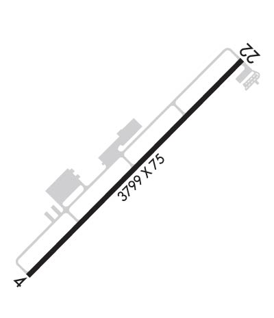
Runway Identifications
Runway Identification: 04/22
Length: 3799 ft
Width: 75 ft
Surface: ASPHALT-GOOD CONDITION
Edge lights: Medium Intensity

Treatment: NONE

 Runway: 04   Runway: 22
Mag heading: 43°Mag heading: 223°
Rwy Slope: .12% UpRwy Slope: -.12% Down
Approach: Approach:
Pattern: Left TrafficPattern: Left Traffic
Markings: NONPRECISION INSTRUMENTMarkings: NONPRECISION INSTRUMENT
Marking Condition: GOODMarking Condition: GOOD
Arresting Dev: Arresting Dev:
Lat & Long: N3105.5  W09204.4Lat. & Long.: N3105.9  W09203.9
Elev: 73.9 ft. MSLElev: 78.3 ft. MSL
TCH: 50 ft. AGLTCH: 50 ft. AGL
Visual Glide Path: 3.00 degreesVisual Glide Path: 3.00 degrees
Displaced Threshold: NoDisplaced Threshold: No
Touchdown Zone: YESTouchdown Zone: YES
Touchdown Elev.: 76.5 feetTouchdown Elev.: 78.3 feet
Visual Glide Slope: 2-Light PAPI on LEFT side of RunwayVisual Glide Slope: 2-Light PAPI on LEFT side of Runway
RVR Equipment: RVR Equipment:
RVV Equipment: NORVV Equipment: NO
Approach Lights: Approach Lights:
REIL: YESREIL: YES
Centerline Lights: NOCenterline Lights: NO
Touchdown lights: NOTouchdown lights: NO
Runway Category: Runway with a Non-precision ApproachRunway Category: Runway with a Visual Approach
Declared Distances: Declared Distances:
Obstructions: Obstructions: POLE
Marked: Marked: MARKED
Clearance slope: 20:1Clearance slope: 20:1
Obstruction height: Obstruction height: 23 feet AGL
Dist. from runway: Dist. from runway: 671 feet
Centerline offset: Centerline offset: 58 feet left of centerline
Comments: Comments:
C:1/P: