Current Weather/Notams (Metars, TAFs, Notams, NWS Forecast, PIREPS, and nearby weather)
Customs Information Send updates to Support@FltPlan.com
Customs Not Available
Database effective 04/18/2024
Airport Diagram might not be current.
|
| Facility Name: | MANKATO RGNL |
| City Name: | MANKATO |
| County: | BLUE EARTH |
| State abbrev: | MN |
| State Name: | MINNESOTA |
| | |
| Ownership: | PUBLICLY OWNED |
| Use: | OPEN TO THE PUBLIC |
| Owner's Name: | CITY OF MANKATO |
| Address: | 10 CIVIC CENTER PLZ, PO BOX 3368 |
| | MANKATO, MN 56001-7794 |
| Owner's Phone: | 507-387-8600 |
| | |
| Manager's Name: | JEFFREY JOHNSON |
| Address: | 3030 N AIRPORT RD |
| | MANKATO, MN 56001-7561 |
| Phone: | 507-387-8640 |
| | |
| FAA Region: | GREAT LAKES |
| FAA Field Office: | DMA |
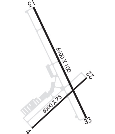
Runway Identifications
Runway Identification: 04/22Length: 4000 ft
Width: 75 ft
Surface: ASPHALT-GOOD CONDITION
Edge lights: Medium IntensityTreatment: NONE
| | Runway: 04 | | Runway: 22 |
| Mag heading: | 47° | Mag heading: | 227° |
| Rwy Slope: | .31% Up | Rwy Slope: | -.31% Down |
| Approach: | | Approach: | |
| Pattern: | Left Traffic | Pattern: | Left Traffic |
| Markings: | NONPRECISION INSTRUMENT | Markings: | NONPRECISION INSTRUMENT |
| Marking Condition: | GOOD | Marking Condition: | GOOD |
| Arresting Dev: | | Arresting Dev: | |
| Lat & Long: | N4412.9 W09355.5 | Lat. & Long.: | N4413.4 W09354.8 |
| Elev: | 1007.2 ft. MSL | Elev: | 1019.7 ft. MSL |
| TCH: | 39 ft. AGL | TCH: | 26 ft. AGL |
| Visual Glide Path: | 3.00 degrees | Visual Glide Path: | 3.00 degrees |
| Displaced Threshold: | No | Displaced Threshold: | No |
| Touchdown Zone: | YES | Touchdown Zone: | YES |
| Touchdown Elev.: | 1017.9 feet | Touchdown Elev.: | 1020.8 feet |
| Visual Glide Slope: | 4-Light PAPI on LEFT side of Runway | Visual Glide Slope: | 4-Light PAPI on LEFT side of Runway |
| RVR Equipment: | | RVR Equipment: | |
| RVV Equipment: | NO | RVV Equipment: | NO |
| Approach Lights: | | Approach Lights: | |
| REIL: | YES | REIL: | YES |
| Centerline Lights: | NO | Centerline Lights: | NO |
| Touchdown lights: | NO | Touchdown lights: | NO |
| Runway Category: | Runway with a Non-precision Approach having visibility minimums greater than 3/4 mile | Runway Category: | Runway with a Non-precision Approach having visibility minimums greater than 3/4 mile |
| Declared Distances: | | Declared Distances: | |
Runway Identification: 15/33Length: 6600 ft
Width: 100 ft
Surface: CONCRETE-GOOD CONDITION
Edge lights: High IntensityTreatment: GROOVED
| | Runway: 15 | | Runway: 33 |
| Mag heading: | 155° | Mag heading: | 335° |
| Rwy Slope: | .03% Up | Rwy Slope: | -.03% Down |
| Approach: | | Approach: | ILS |
| Pattern: | Left Traffic | Pattern: | Left Traffic |
| Markings: | PRECISION INSTRUMENT | Markings: | PRECISION INSTRUMENT |
| Marking Condition: | GOOD | Marking Condition: | GOOD |
| Arresting Dev: | | Arresting Dev: | |
| Lat & Long: | N4414.0 W09355.5 | Lat. & Long.: | N4413.0 W09354.8 |
| Elev: | 1018.7 ft. MSL | Elev: | 1020.8 ft. MSL |
| TCH: | 48 ft. AGL | TCH: | 49 ft. AGL |
| Visual Glide Path: | 3.00 degrees | Visual Glide Path: | 3.00 degrees |
| Displaced Threshold: | No | Displaced Threshold: | No |
| Touchdown Zone: | YES | Touchdown Zone: | YES |
| Touchdown Elev.: | 1019.8 feet | Touchdown Elev.: | 1020.8 feet |
| Visual Glide Slope: | 4-Light PAPI on LEFT side of Runway | Visual Glide Slope: | 4-Light PAPI on LEFT side of Runway |
| RVR Equipment: | | RVR Equipment: | |
| RVV Equipment: | NO | RVV Equipment: | NO |
| Approach Lights: | | Approach Lights: | MALSR - 1,400 foot medium intensity approach lighting system with runway alignment indicator lights |
| REIL: | YES | REIL: | NO |
| Centerline Lights: | NO | Centerline Lights: | NO |
| Touchdown lights: | NO | Touchdown lights: | NO |
| Runway Category: | Runway with a Non-precision Approach having visibility minimums greater than 3/4 mile | Runway Category: | Precision Instrument Runway |
| Declared Distances: | | Declared Distances: | |
| Obstructions: | | Obstructions: | CROPS |
| Marked: | | Marked: | NOT Marked/Lighted |
| Clearance slope: | 50:1 | Clearance slope: | 32:1 |
| Obstruction height: | | Obstruction height: | 8 feet AGL |
| Dist. from runway: | | Dist. from runway: | 456 feet |
| Centerline offset: | | Centerline offset: | 267 feet left of centerline |
| Comments: | | Comments: | |

