Current Weather/Notams (Metars, TAFs, Notams, NWS Forecast, PIREPS, and nearby weather)
Customs Information Send updates to Support@FltPlan.com
Customs Not Available
Database effective 05/16/2024
Airport Diagram might not be current.
|
| Facility Name: | BERKELEY COUNTY |
| City Name: | MONCKS CORNER |
| County: | BERKELEY |
| State abbrev: | SC |
| State Name: | SOUTH CAROLINA |
| | |
| Ownership: | PUBLICLY OWNED |
| Use: | OPEN TO THE PUBLIC |
| Owner's Name: | COUNTY OF BERKELEY |
| Address: | P.O. BOX 6122 |
| | MONCKS CORNER, SC 29461 |
| Owner's Phone: | 843-899-7711 |
| | |
| Manager's Name: | STACY THOMAS |
| Address: | 616 WHITESVILLE ROAD |
| | MONCKS CORNER, SC 29461 |
| Phone: | (843) 719-4751 |
| | |
| FAA Region: | SOUTHERN |
| FAA Field Office: | ATL |
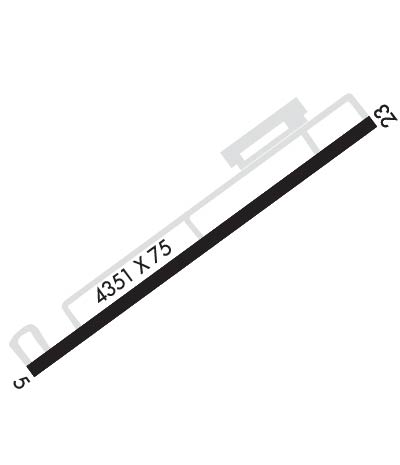
Runway Identifications
Runway Identification: 05/23Length: 5001 ft
Width: 75 ft
Surface: CONCRETE
Edge lights: Medium IntensityTreatment: NONE
Weight: PCN 20 /R/B/X/T
| | Runway: 05 | | Runway: 23 |
| Mag heading: | 50° | Mag heading: | 230° |
| Rwy Slope: | -.10% Down | Rwy Slope: | .10% Up |
| Approach: | | Approach: | |
| Pattern: | Left Traffic | Pattern: | Left Traffic |
| Markings: | NONPRECISION INSTRUMENT | Markings: | NONPRECISION INSTRUMENT |
| Marking Condition: | GOOD | Marking Condition: | GOOD |
| Arresting Dev: | | Arresting Dev: | |
| Lat & Long: | N3310.8 W08002.6 | Lat. & Long.: | N3311.4 W08001.9 |
| Elev: | 74.0 ft. MSL | Elev: | 69.1 ft. MSL |
| TCH: | | TCH: | 44 ft. AGL |
| Visual Glide Path: | | Visual Glide Path: | 3.00 degrees |
| Displaced Threshold: | 650 feet | Displaced Threshold: | No |
| Touchdown Zone: | YES | Touchdown Zone: | YES |
| Touchdown Elev.: | 74.0 feet | Touchdown Elev.: | 73.6 feet |
| Visual Glide Slope: | | Visual Glide Slope: | 2-Light PAPI on LEFT side of Runway |
| RVR Equipment: | | RVR Equipment: | |
| RVV Equipment: | NO | RVV Equipment: | NO |
| Approach Lights: | | Approach Lights: | |
| REIL: | NO | REIL: | NO |
| Centerline Lights: | NO | Centerline Lights: | NO |
| Touchdown lights: | NO | Touchdown lights: | NO |
| Runway Category: | Runway with a Non-precision Approach having visibility minimums greater than 3/4 mile | Runway Category: | Runway with a Non-precision Approach having visibility minimums greater than 3/4 mile |
| Declared Distances: | | Declared Distances: | |
| Obstructions: | TREE | Obstructions: | TREE |
| Marked: | NOT Marked/Lighted | Marked: | NOT Marked/Lighted |
| Clearance slope: | 17:1 | Clearance slope: | 17:1 |
| Obstruction height: | 91 feet AGL | Obstruction height: | 96 feet AGL |
| Dist. from runway: | 1758 feet | Dist. from runway: | 1898 feet |
| Centerline offset: | 439 left of centerline | Centerline offset: | 500 feet right of centerline |
| Comments: | | Comments: | |

