Click here for more info on on SMS!

KMKL

MC KELLAR-SIPES RGNL
JACKSON
TN
Time Zone: Central
Lat: N 3536.0
Long: W 08854.9
Elev: 433
Var: +01
Longest Runway: 6005
AWOS: 119.32
Ground: 120.9
Tower: 127.15

FBO & Flight Services info for KMKL

FBOs: Update your Fuel Prices

MCKELLAR-SIPESPh: 731-427-0191
-
Freq: 122.95
Service
Jet
100LL
SAF
MoGas
Fuel Avail: PRIST+$0.05/gal 24/7 Self Service
Full6.256.50    Last Update: 04/19/2024 13:28

Self5.255.50    
 Address: 308 GRADY MONTGOMERY DR.,   JACKSON, TN 38301
ASOSPh: 731-424-0692
-
Freq: 119.32  
If you are an FBO, call 1-203-262-1700 to update your info or email: FltPlan.Advertising@garmin.com
Advertise your FBO on FltPlan.com

Runway & Approach Info for KMKL
Rwy
Length
Land Dist**
Approach*
  Rwy
Length
Land Dist**
Approach*
02
6005x150  6005'          
ILS/DME
 109.10 - 023°  
  
20
  6005x150  6005'          
 
11
3539x100  3539'          
 
  
29
  3539x100  3539'          
 
 * only ILS, LOC, LDA, and SDF approaches to a specific runway are shown
** For any Declared Landing Distance Available, please see A/FD or Approach plates
Runway Weight Capability (lbs.) Help
Runway IDSingle WheelDouble WheelDouble Tandem WheelDual Double Wheel
02/2055,00080,000125,000N/A
11/2927,000N/AN/AN/A
These numbers are Advisory and are not limits.   The Airport Manager should have more accurate Weight Limits
Approach Charts
Approaches    
Current Weather/Notams
Customs Information Send updates to Support@FltPlan.com
Customs Not Available
Database effective 04/18/2024
Airport Diagram of KMKL
Airport Diagram might not be current.

Facility Name: MC KELLAR-SIPES RGNL
City Name: JACKSON
County: MADISON
State abbrev: TN
State Name: TENNESSEE
   
Ownership: PUBLICLY OWNED
Use: OPEN TO THE PUBLIC
Owner's Name: JACKSON & MADISON CO ARPT AUTH
Address: 308 GRADY MONTGOMERY DR
 JACKSON, TN 38301
Owner's Phone: 731-423-0995
  
Manager's Name: STEVE SMITH
Address: 308 GRADY MONTGOMERY DR
 JACKSON, TN 38301
Phone: 731-423-0995
   
FAA Region: SOUTHERN
FAA Field Office: MEM


Sunrise / Sunset times for MC KELLAR-SIPES RGNL

DateSunriseSunset
04/18/24 Thursday6:1819:32
04/19/24 Friday6:1719:33
04/20/24 Saturday6:1619:34
04/21/24 Sunday6:1419:35
04/22/24 Monday6:1319:35
04/23/24 Tuesday6:1219:36
04/24/24 Wednesday6:1119:37
04/25/24 Thursday6:1019:38
04/26/24 Friday6:0919:39
04/27/24 Saturday6:0719:40
04/28/24 Sunday6:0619:40
04/29/24 Monday6:0519:41
04/30/24 Tuesday6:0419:42
05/01/24 Wednesday6:0319:43

Airport Facilities

Airport Attendance ScheduleMON-FRI 0600-2030, SAT-SUN 0700-1930; AFT HR - 731-394-1755.
Airport Status OPERATIONAL (This Status can change at any time - please check NOTAMS)
Airport Lighting ScheduleWHEN ATCT CLSD ACTVT MALSR RWY 02; HIRL RWY 02/20, MIRL RWY 11/29 - CTAF.
Airport Storage AvailableTie Downs, Hanger
Extra Services AvailableAir Freight, Avionics, Charter, Flight Instruction, Aircraft Rental, Aircraft Sales
Wind IndicatorYES - (lighted)
Control TowerYES
CTAF Frequency127.150
Unicom Frequency122.950
Rotating Beacon ColorWG
Segmented CircleYES
Landing FeeNO

Airport Inspection Data

Airport InspectedFEDERAL - performed by FAA AIRPORTS FIELD PERSONNEL
Inspection Date08/17/2022

Airport Services

Type of Fuel AvailableGrade 100LL, JET A (freeze point -40C)
Airframe Repair ServiceMAJOR
Power Plant Repair ServiceMAJOR

Geographic Data

LatitudeN3536.0
LongitudeW08854.9 (ESTIMATED)
Arpt Elevation433ft (SURVEYED)
Magnetic Variation01W
4 miles Wof JACKSON
Traffic Pattern Altitude
Sectional ChartMEMPHIS

Aircraft Data

Operations (Reported)YearlyAvg. Daily
General Aviation Transient 1554843
General Aviation Local 1227834
Air Taxi 16084
Commerical 00
Commuter 00
Military 22626
Aircraft based on Field
General Aviation Singles 33
General Aviation Multi 11
Jet Aircraft 6
General Aviation Helicopters 3
Military Aircraft 8
Gliders 0
Ultralights 0

FAA Services

FSS on field NO
FSS tie-in JACKSON
FSS Phone 1-800-WX-BRIEF
Who issues Notams MKL
Notam D service at airport YES
ARTCC Name MEMPHIS

Federal Status

Airport CertificationAIRPORT RECEIVING SCHEDULED AIR CARRIER SERVICE FROM CARRIERS CERTIFICATED BY THE CIVIL AERONAUTICS BOARD; CLSD TO UNSKED ACR OPS MORE THAN 30 PAX SEATS EXC 24 HR PPR - AMGR.
Aircraft Rescue & Firefighting IndexAIRPORT HAS A CERTIFICATE UNDER CFR PART 139
Airport of EntryNo
Custom Landing RightsNo
Joint Civil/MilitaryNo
Military Landing rightsYES

Federal Agreements

NATIONAL PLAN OF INTEGRATED AIRPORT SYSTEMS (NPIAS)
GRANT AGREEMENTS UNDER FAAP/ADAP/AIP
SURPLUS PROPERTY AGREEMENT UNDER REGULATION 16-WAA
ASSURANCES PURSUANT TO TITLE VI, CIVIL RIGHTS ACT OF 1964
AGREEMENT UNDER DLAND OR DCLA HAS EXPIRED.

Remarks

BASE OPS 0630-1600 MON-FRI; PPR C731-425-5600.
PPR FOR GND ACCESS TO FLD 2130-0600 - 731-394-1755.
ACR OPS MORE THAN 9 PAX SEATS NA IN EXCESS OF 15 MIN BFR OR AFT SKED ARR OR DEP TIMES WO PRIOR AVBLTY COORD WITH AMGR & CFM.
FOR CD CTC MEMPHIS ARTCC AT 901-368-8453/8449.
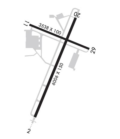
RWY 02/2 0 FADED.
RWY 11/2 9 FADED.
RWY 02/2 0 GROOVED 55 FT EACH SIDE OF CNTRLN.
Airport Communications & Frequencies:
JACKSON Tower Frequencies:   Hours(local) of operation: 0700-1900   
127.15
249.95
JACKSON Ground Frequencies:
120.9
CTAF Frequency:
127.150
Unicom Frequency:
122.950
Remarks
  • APCH/DEP SVC PRVDD BY MEMPHIS ARTCC ON FREQS 134.65/316.15 (MCKELLAR RCAG).
  • Runway Identifications
    Runway Identification: 02/20
    Length: 6005 ft
    Width: 150 ft
    Surface: ASPHALT-FAIR CONDITION
    Edge lights: High Intensity

    Treatment: GROOVED
    Weight: PCN 34 /F/C/X/T

     Runway: 02   Runway: 20
    Mag heading: 23°Mag heading: 203°
    Rwy Slope: -.37% DownRwy Slope: .37% Up
    Approach: ILS/DMEApproach:
    Pattern: Left TrafficPattern: Left Traffic
    Markings: PRECISION INSTRUMENTMarkings: NONPRECISION INSTRUMENT
    Marking Condition: FAIRMarking Condition: FAIR
    Arresting Dev: Arresting Dev:
    Lat & Long: N3535.4  W08855.2Lat. & Long.: N3536.3  W08854.7
    Elev: 433.3 ft. MSLElev: 411.2 ft. MSL
    TCH: 29 ft. AGLTCH: 47 ft. AGL
    Visual Glide Path: 3.00 degreesVisual Glide Path: 3.00 degrees
    Displaced Threshold: NoDisplaced Threshold: No
    Touchdown Zone: YESTouchdown Zone: YES
    Touchdown Elev.: 433.3 feetTouchdown Elev.: 418.1 feet
    Visual Glide Slope: 4-Light PAPI on LEFT side of Runway; PAPI UNUSBL BYD 8 DEG LEFT AND RIGHT OF CNTRLN.Visual Glide Slope: 4-Light PAPI on LEFT side of Runway
    RVR Equipment: RVR Equipment:
    RVV Equipment: NORVV Equipment: NO
    Approach Lights: MALSR - 1,400 foot medium intensity approach lighting system with runway alignment indicator lightsApproach Lights:
    REIL: NOREIL: NO
    Centerline Lights: NOCenterline Lights: NO
    Touchdown lights: NOTouchdown lights: NO
    Runway Category: Precision Instrument RunwayRunway Category: Runway with a Non-precision Approach having visibility minimums greater than 3/4 mile
    Declared Distances: Declared Distances:
    Obstructions: Obstructions: TREE
    Marked: Marked: NOT Marked/Lighted
    Clearance slope: 50:1Clearance slope: 30:1
    Obstruction height: Obstruction height: 40 feet AGL
    Dist. from runway: Dist. from runway: 1400 feet
    Centerline offset: Centerline offset: 600 feet right of centerline
    Comments: Comments:
    Runway Identification: 11/29
    Length: 3539 ft
    Width: 100 ft
    Surface: ASPHALT-FAIR CONDITION
    Edge lights: Medium Intensity

    Treatment: NONE
    Weight: PCN 13 /F/D/X/T

     Runway: 11   Runway: 29
    Mag heading: 113°Mag heading: 293°
    Rwy Slope: .23% UpRwy Slope: -.23% Down
    Approach: Approach:
    Pattern: Left TrafficPattern: Left Traffic
    Markings: BASICMarkings: BASIC
    Marking Condition: FAIRMarking Condition: FAIR
    Arresting Dev: Arresting Dev:
    Lat & Long: N3536.3  W08855.2Lat. & Long.: N3536.1  W08854.6
    Elev: 407.6 ft. MSLElev: 415.7 ft. MSL
    TCH: 34 ft. AGLTCH: 23 ft. AGL
    Visual Glide Path: 3.00 degreesVisual Glide Path: 3.00 degrees
    Displaced Threshold: NoDisplaced Threshold: No
    Touchdown Zone: YESTouchdown Zone: YES
    Touchdown Elev.: 415.5 feetTouchdown Elev.: 415.8 feet
    Visual Glide Slope: 4-Light PAPI on LEFT side of RunwayVisual Glide Slope: 4-Light PAPI on LEFT side of Runway
    RVR Equipment: RVR Equipment:
    RVV Equipment: NORVV Equipment: NO
    Approach Lights: Approach Lights:
    REIL: NOREIL: NO
    Centerline Lights: NOCenterline Lights: NO
    Touchdown lights: NOTouchdown lights: NO
    Runway Category: Runway with a Visual ApproachRunway Category: Runway with a Visual Approach
    Declared Distances: Declared Distances:
    Obstructions: TREEObstructions: TREE
    Marked: NOT Marked/LightedMarked: NOT Marked/Lighted
    Clearance slope: 21:1Clearance slope: 20:1
    Obstruction height: 66 feet AGLObstruction height: 45 feet AGL
    Dist. from runway: 1650 feetDist. from runway: 1100 feet
    Centerline offset: 50 right of centerlineCenterline offset: 320 feet left of centerline
    Comments: Comments:
    C:40/P: