Click here for more info on on SMS!

KMKC

CHARLES B. WHEELER DOWNTOWN
KANSAS CITY
MO
Time Zone: Central
Lat: N 3907.4
Long: W 09435.6
Elev: 757
Var: -01
Longest Runway: 6827
Clr Del: 121.9
Dept. ATIS: 120.75
Arr. ATIS: 120.75
AWOS: 120.75
Ground: 121.9
Tower: 133.3

FBO & Flight Services info for KMKC

FBOs: Update your Fuel Prices
Atlantic Aviation is your premier aviation service provider with more than 100 locations in North America, including Hawaii and the Caribbean. We provide standard ground services you'd expect, with a detailed focus on ensuring an unforgettable customer experience.
Ph: 816-949-8900 Fax: 816-949-8901 Freq: 129.10WebsiteE-Mail
                               
Service
Jet
100LL
SAF
MoGas
Fuel Avail: Open 24 Hours, 7 Days per Week
Full7.74      Last Update: 04/24/2024 13:37:45
PRICES GUARANTEED by FBO.
Self        
Misc. Info: Address: 1001 NW LOU HOLLAND DR,   KANSAS CITY, MO 64116

  click here  
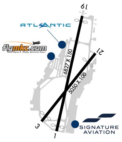
Charles B. Wheeler Downtown Airport is the city's first airport and it is still one of the busiest. Dedicated by Charles Lindbergh in 1927, the Downtown Airport is just across the Missouri River from Kansas City's business center. Airport users have easy access to the metropolitan area and it is an ideal refueling stop for air travelers going cross country.
Ph: 816-842-8484
-
Freq: 129.57WebsiteE-Mail
                          
Service
Jet
100LL
SAF
MoGas
Fuel Avail: PRIST+ $0.05/gal Open 24 hours, 7 Days a week
Full7.579.82    Last Update: 04/24/2024 09:41
PRICES GUARANTEED by FBO.
Self        
Misc. Info: We will match all reasonable local fuel discounts; Fax temporarily down til 11/1Address: 10 RICHARDS ROAD,   KANSAS CITY, MO 64116

  click here  
This new complex provides general aviation aircraft operators a full line of amenities on a self-serve basis. The general aviation terminal provides amenities for pilot flight planning, showers, office & lounging. Hangar tenants & fueling customers have access to this facility free of charge. Self-serve 100LL is available on the northwest side of the airfield.
Ph: 816-859-7612
-
-
WebsiteE-Mail
                                         
Service
Jet
100LL
SAF
MoGas
Full        Caution: Fuel prices have not been updated in 31 days.
Last Update: 03/25/2024 22:12

Self  5.09    
Misc. Info: Access code for entry into the GA Terminal is on the bottom of the fuel receiptAddress: 925 LOU HOLLAND DR   KANSAS CITY, MO 64116

ATISPh: 816-329-2850
-
Freq: 120.75  
ASOSPh: 816-329-2843
-
-
 
If you are an FBO, call 1-203-262-1700 to update your info or email: FltPlan.Advertising@garmin.com
Advertise your FBO on FltPlan.com
FBOs at nearby airports who want your business:
KIXD


  click here  
Advanced Jet Center is Kansas City's Premier FBO 95 Full Concierge Service 95 No Ramp Fees 95 Daily Fuel Specials 95 QuickTurn Central 95 X/C Fuel Specials 95 EASYMONEY Pilot Rewards 95 Kansas City Famous BBQ, Beer and Coffee Now Available!
Ph: 913-768-1500 WebsiteE-MailFax: 913-764-4831 Freq: 122.9
KLXT

The Lee's Summit Airport now offers a 5,501 ft. grooved runway along with a full service FBO that now serves the Greater Kansas City area. The Lee's Summit Airport is only minutes away from locationsSouth of Downtown including Arrowhead Stadium, Kaufman Stadium, and the Plaza shopping area. Additionally, Lee's Summit is minutes away from locations in Independence and Overland Park.
Ph: 1-816-969-1186WebsiteE-MailFax: 1-816-969-1184Freq: 122.80

Runway & Approach Info for KMKC
Rwy
Length
Land Dist**
Approach*
  Rwy
Length
Land Dist**
Approach*
01
6827x150  6528'          
 
  
19
  6827x150  6525'          
ILS/DME
 109.90 - 191°  
04
5050x100  4550'          
ILS/DME
 111.75 - 035°  
  
22
  5050x100  4351'          
 
 * only ILS, LOC, LDA, and SDF approaches to a specific runway are shown
** For any Declared Landing Distance Available, please see A/FD or Approach plates
Runway Weight Capability (lbs.) Help
Runway IDSingle WheelDouble WheelDouble Tandem WheelDual Double Wheel
01/1986,000171,000342,000N/A
04/2248,00073,000136,000N/A
These numbers are Advisory and are not limits.   The Airport Manager should have more accurate Weight Limits
Approach Charts
Approaches    
Current Weather/Notams
Customs Information Send updates to Support@FltPlan.com
Phone 816-780-6100
Fax 816-243-3677

Comments 2 hr advance notice required. Business hrs 0800-1630 Monday-Friday. *Maximum passengers per flight: 30 *M-F Call prior to 1630 on preceeding weekday *WKND Call prior to 1630 on preceeding Friday
Database effective 05/16/2024
Airport Diagram of KMKC
Airport Diagram might not be current.

Facility Name: CHARLES B WHEELER DOWNTOWN
City Name: KANSAS CITY
County: CLAY
State abbrev: MO
State Name: MISSOURI
   
Ownership: PUBLICLY OWNED
Use: OPEN TO THE PUBLIC
Owner's Name: CITY OF KANSAS CITY
Address: 414 E. 12TH ST
 KANSAS CITY, MO 64106
Owner's Phone: 816-859-7601
  
Manager's Name: ROD DEWINKLER
Address: 900 NW RICHARDS ROAD
 KANSAS CITY, MO 64116
Phone: 816-859-7610
   
FAA Region: CENTRAL
FAA Field Office: NONE


Sunrise / Sunset times for CHARLES B WHEELER DOWNTOWN

DateSunriseSunset
04/24/24 Wednesday6:2820:05
04/25/24 Thursday6:2720:06
04/26/24 Friday6:2520:07
04/27/24 Saturday6:2420:08
04/28/24 Sunday6:2320:09
04/29/24 Monday6:2220:10
04/30/24 Tuesday6:2020:11
05/01/24 Wednesday6:1920:12
05/02/24 Thursday6:1820:13
05/03/24 Friday6:1720:14
05/04/24 Saturday6:1620:15
05/05/24 Sunday6:1520:16
05/06/24 Monday6:1320:17
05/07/24 Tuesday6:1220:18

Airport Facilities

Airport Attendance ScheduleCONTINUOUS
Airport Status OPERATIONAL (This Status can change at any time - please check NOTAMS)
Airport Lighting ScheduleSS-SR
Airport Storage AvailableTie Downs, Hanger
Extra Services AvailableAir Freight, Avionics, Cargo Handling, Charter, Flight Instruction, Aircraft Rental, Aircraft Sales, Annual Surveying
Wind IndicatorYES - (lighted)
Control TowerYES
CTAF Frequency
Unicom Frequency122.950
Rotating Beacon ColorWG
Segmented CircleNO
Landing FeeNO

Airport Inspection Data

Airport InspectedFEDERAL - performed by FAA AIRPORTS FIELD PERSONNEL
Inspection Date10/11/2023

Airport Services

Type of Fuel AvailableGrade 100LL, JET A (freeze point -40C); -10100LL SELF SVC AVBL 24 HRS WITH CREDIT CARD ONLY ON WEST SIDE NEAR GA TERMINAL.
Airframe Repair ServiceMAJOR
Power Plant Repair ServiceMAJOR

Geographic Data

LatitudeN3907.4
LongitudeW09435.6 (ESTIMATED)
Arpt Elevation756ft (SURVEYED)
Magnetic Variation01E
0 miles NWof KANSAS CITY
Traffic Pattern Altitude
Sectional ChartKANSAS CITY

Aircraft Data

Operations (Reported)YearlyAvg. Daily
General Aviation Transient 53529147
General Aviation Local 38543106
Air Taxi 3058484
Commerical 4961
Commuter 00
Military 10623
Aircraft based on Field
General Aviation Singles 76
General Aviation Multi 21
Jet Aircraft 81
General Aviation Helicopters 12
Military Aircraft 0
Gliders 0
Ultralights 0

FAA Services

FSS on field NO
FSS tie-in COLUMBIA
FSS Phone 1-800-WX-BRIEF
Who issues Notams MKC
Notam D service at airport YES
ARTCC Name KANSAS CITY

Federal Status

Airport CertificationARPT CLSD TO ACR OPNS WITH MORE THAN 30 PSGR SEATS EXCP 24 HR PPR CALL AMGR (816) 289-2718. AIR CARRIER OPS NOT AUTHORIZED IN EXCESS OF 15 MINUTES BFR OR AFT SKED ARR OR DEP TIMES W/O PRIOR COORDINATION WITH AMGR CONFIRMING ARFF AVBL PRIOR TO LNDG OR TKOF.
Aircraft Rescue & Firefighting IndexAIRPORT HAS A CERTIFICATE UNDER CFR PART 139
Airport of EntryNo
Custom Landing RightsYES
Joint Civil/MilitaryNo
Military Landing rightsYES

Federal Agreements

NATIONAL PLAN OF INTEGRATED AIRPORT SYSTEMS (NPIAS)
GRANT AGREEMENTS UNDER FAAP/ADAP/AIP
ASSURANCES PURSUANT TO TITLE VI, CIVIL RIGHTS ACT OF 1964

Remarks

FLOCKS OF PIGEONS INVOF DEP EOR 04.
RWY 04/22 VFR E TFC PAT: DEPARTING RWY 04 RIGHT TFC ATTAIN TFC PAT ALT PRIOR TO TURNING CROSSWIND. LDG RWY 22 MNTN TFC PAT ALT UNTIL PASSING N OF MISSOURI RIVER.
ATCT HAS LIMITED VISIBILITY OF T-HANGAR APRONS N TWY D AND W TWY L .
FAA SAFETY VIDEO CAN BE ACCESSED AT HTTPS://WWW.FAA.GOV/AIRPORTS/RUNWAY_SAFETY/VIDEOS/MKC/
CTN: MULT OBSTRUCTIONS 0.5 MI-1.0 MI ESE FM RWY 19 DER UP TO 290 FT AGL/1100 FT MSL.
DUE TO OBSTNS, PRIOR TO ANY TURNS TO THE E, ACFT MUST BE AT OR ABV TFC PTN ALT
WILDLIFE ON & INVOF ARPT.
Airport Communications & Frequencies:
ATIS Frequencies:   Hours(local) of Operation: CONTINUOUS
120.75
DOWNTOWN Tower Frequencies:   Hours(local) of operation: CONTINUOUS   
133.3
233.7
DOWNTOWN Ground Frequencies:
121.9
Clearance Delivery Frequencies:
121.9
Pre-Taxi Clearance Frequencies:
121.9
Unicom Frequency:
122.950
Remarks
  • INTERFERENCE FROM FM RADIO STATION MAY AFFECT COMMUNICATIONS IN THE IMMEDIATE VICINITY OF THE ARPT.
  • KANSAS CITY Primary Approach Frequencies:  
    118.4
    307.35
    KANSAS CITY Primary Departure Frequencies:  
    118.4
    307.35
    Runway Identifications
    Runway Identification: 01/19
    Length: 6827 ft
    Width: 150 ft
    Surface: CONCRETE
    Edge lights: High Intensity

    Treatment: GROOVED
    Weight: PCN 67 /R/B/W/T

     Runway: 01   Runway: 19
    Mag heading: 12°Mag heading: 192°
    Rwy Slope: .12% UpRwy Slope: -.12% Down
    Approach: Approach: ILS/DME
    Pattern: Left TrafficPattern: Left Traffic
    Markings: NONPRECISION INSTRUMENTMarkings: PRECISION INSTRUMENT
    Marking Condition: GOODMarking Condition: GOOD
    Arresting Dev: EMAS; ENGINEERED MATERIALS ARRESTING SYSYTEM (EMAS) 263 FT IN LENGTH BY 170 FT IN WIDTH LCTD AT THE DER 01.Arresting Dev: EMAS; ENGINEERED MATERIALS ARRESTING SYSYTEM (EMAS) 287 FT IN LENGTH BY 170 FT IN WIDTH LCTD AT THE DER 19.
    Lat & Long: N3906.9  W09435.7Lat. & Long.: N3908.0  W09435.4
    Elev: 748.5 ft. MSLElev: 756.8 ft. MSL
    TCH: 66 ft. AGLTCH: 46 ft. AGL
    Visual Glide Path: 3.70 degreesVisual Glide Path: 3.00 degrees
    Displaced Threshold: 299 feetDisplaced Threshold: 302 feet
    Touchdown Zone: YESTouchdown Zone: YES
    Touchdown Elev.: 746.5 feetTouchdown Elev.: 754.4 feet
    Visual Glide Slope: 4-BOX VASI ON LEFT SIDE OF RUNWAYVisual Glide Slope: 4-Light PAPI on LEFT side of Runway
    RVR Equipment: ROLLOUTRVR Equipment: TOUCHDOWN
    RVV Equipment: NORVV Equipment: NO
    Approach Lights: RLLSApproach Lights: MALSF - 1,400 foot medium intensity approach lighting system with sequenced flashers; RY19 MALSF AUGMENTED WITH RAIL.
    REIL: YESREIL: NO
    Centerline Lights: NOCenterline Lights: NO
    Touchdown lights: NOTouchdown lights: NO
    Runway Category: Runway with a Visual ApproachRunway Category: Precision Instrument Runway
    Declared Distances: TORA:6827' TODA:6827' ASDA:6827' LDA:6527'Declared Distances: TORA:6827' TODA:6827' ASDA:6827' LDA:6525'
    Obstructions: TREEObstructions: ROAD
    Marked: NOT Marked/LightedMarked: NOT Marked/Lighted
    Clearance slope: 20:1Clearance slope: 25:1
    Obstruction height: 38 feet AGLObstruction height: 20 feet AGL
    Dist. from runway: 747 feetDist. from runway: 700 feet
    Centerline offset: 571 right of centerlineCenterline offset: 150 feet left of centerline
    Comments: Comments: ROAD & FENCE 0-200' FM THR.
    Runway Identification: 04/22
    Length: 5050 ft
    Width: 100 ft
    Surface: ASPHALT
    Edge lights: High Intensity

    Treatment: NONE
    Weight: PCN 74 /F/C/W/T

     Runway: 04   Runway: 22
    Mag heading: 37°Mag heading: 217°
    Rwy Slope: .01% UpRwy Slope: -.01% Down
    Approach: ILS/DMEApproach:
    Pattern: Left TrafficPattern: Left Traffic
    Markings: PRECISION INSTRUMENTMarkings: NONPRECISION INSTRUMENT
    Marking Condition: GOODMarking Condition: GOOD
    Arresting Dev: Arresting Dev:
    Lat & Long: N3907.0  W09435.9Lat. & Long.: N3907.6  W09435.2
    Elev: 742.3 ft. MSLElev: 742.9 ft. MSL
    TCH: 35 ft. AGLTCH: 35 ft. AGL
    Visual Glide Path: 3.00 degreesVisual Glide Path: 3.30 degrees
    Displaced Threshold: 500 feetDisplaced Threshold: 699 feet
    Touchdown Zone: YESTouchdown Zone: YES
    Touchdown Elev.: 743.8 feetTouchdown Elev.: 743.9 feet
    Visual Glide Slope: 4-BOX VASI ON LEFT SIDE OF RUNWAYVisual Glide Slope: 4-BOX VASI ON LEFT SIDE OF RUNWAY; UNUSBL BYD 8 DEGS LEFT OF CRS.
    RVR Equipment: TOUCHDOWNRVR Equipment: ROLLOUT
    RVV Equipment: NORVV Equipment: NO
    Approach Lights: Approach Lights:
    REIL: NOREIL: YES
    Centerline Lights: NOCenterline Lights: NO
    Touchdown lights: NOTouchdown lights: NO
    Runway Category: Precision Instrument RunwayRunway Category: Runway with a Non-precision Approach having visibility minimums greater than 3/4 mile
    Declared Distances: TORA:5050' TODA:5050' ASDA:4770' LDA:4270'Declared Distances: TORA:5050' TODA:5050' ASDA:5050' LDA:4351'
    Obstructions: BERMObstructions: RR
    Marked: LIGHTEDMarked: LIGHTED
    Clearance slope: 12:1; APCH RATIO AT DSPLCD THR 47:1.Clearance slope: APCH RATIO AT DSPLCD THR 24:1.
    Obstruction height: 20 feet AGLObstruction height: 37 feet AGL
    Dist. from runway: 450 feetDist. from runway: 225 feet
    Centerline offset: 125 left of centerlineCenterline offset: 100 feet left of centerline
    Comments: Comments: ROAD & RR 0-200' FM THR.
    C:321/P: