
| ||||||||||||||||||||||||||||||||||||||||||||
| ||||||||||||||||||||||||||||||||||||||||||||
| ||||||||||||||||||||||||||||||||||||||||||||
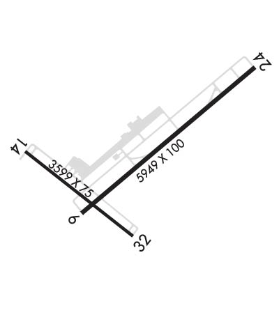
| Rwy | Rwy | |||||||
| 5950x100 | 5950' | 109.90 - 062° | 5950x100 | 5835' | ||||
| 3599x75 | 3599' | 3599x75 | 3599' | |||||
| Runway ID | Single Wheel | Double Wheel | Double Tandem Wheel | Dual Double Wheel |
| 06/24 | 100,000 | 176,000 | 581,000 | N/A |
| 14/32 | 94,000 | 150,000 | N/A | N/A |
| H1 | N/A | N/A | N/A | N/A |
| These numbers are Advisory and are not limits. The Airport Manager should have more accurate Weight Limits | ||||
 Airport Diagram might not be current. | |
| Facility Name: | OCEAN COUNTY |
| City Name: | TOMS RIVER |
| County: | OCEAN |
| State abbrev: | NJ |
| State Name: | NEW JERSEY |
| Ownership: | PUBLICLY OWNED |
| Use: | OPEN TO THE PUBLIC |
| Owner's Name: | COUNTY OF OCEAN |
| Address: | 101 HOOPER AVENUE, PO BOX 2191 |
| TOMS RIVER, NJ 08754-2191 | |
| Owner's Phone: | 732-929-2054 |
| Manager's Name: | ANTHONY AGLIATA |
| Address: | 129 HOOPER AVENUE, PO BOX 2191 |
| TOMS RIVER, NJ 08754-2191 | |
| Phone: | (732) 929-2054 |
| FAA Region: | EASTERN |
| FAA Field Office: | HAR |

| Date | Sunrise | Sunset |
|---|---|---|
| 04/23/24 Tuesday | 6:07 | 19:44 |
| 04/24/24 Wednesday | 6:06 | 19:45 |
| 04/25/24 Thursday | 6:04 | 19:46 |
| 04/26/24 Friday | 6:03 | 19:47 |
| 04/27/24 Saturday | 6:02 | 19:48 |
| 04/28/24 Sunday | 6:00 | 19:49 |
| 04/29/24 Monday | 5:59 | 19:51 |
| 04/30/24 Tuesday | 5:58 | 19:52 |
| 05/01/24 Wednesday | 5:56 | 19:53 |
| 05/02/24 Thursday | 5:55 | 19:54 |
| 05/03/24 Friday | 5:54 | 19:55 |
| 05/04/24 Saturday | 5:53 | 19:56 |
| 05/05/24 Sunday | 5:52 | 19:56 |
| 05/06/24 Monday | 5:51 | 19:57 |
| Airport Attendance Schedule | NOV - MAR 7 Days A Week 0800-1700, APR - OCT 7 Days A Week 0800-2000; UNATNDD CHRISTMAS & NEW YEARS DAY. PREARRANGE FOR SVCS AFT HRS CALL 732-797-1077. |
| Airport Status | OPERATIONAL (This Status can change at any time - please check NOTAMS) |
| Airport Lighting Schedule | ACTVT MALSR RWY 06; REIL RWY 14, 32 & 24; PAPI RWY 06, 24, 14 & 32; HIRL RWY 06/24; MIRL RWY 14/32 - CTAF. |
| Airport Storage Available | Tie Downs, Hanger |
| Extra Services Available | Air Ambulance, Avionics, Flight Instruction, Aircraft Rental, Aircraft Sales |
| Wind Indicator | YES - (lighted) |
| Control Tower | NO |
| CTAF Frequency | 122.700 |
| Unicom Frequency | 122.700 |
| Rotating Beacon Color | WG |
| Segmented Circle | YES |
| Landing Fee | NO |
| Airport Inspected | STATE - performed by PRIVATE CONTRACT PERSONNEL |
| Inspection Date | 01/17/2024 |
| Type of Fuel Available | Grade 100LL, JET A (freeze point -40C) |
| Airframe Repair Service | MAJOR |
| Power Plant Repair Service | MAJOR |
| Latitude | N3955.6 |
| Longitude | W07417.7 (ESTIMATED) |
| Arpt Elevation | 86ft (SURVEYED) |
| Magnetic Variation | 13W |
| 5 miles SW | of TOMS RIVER |
| Traffic Pattern Altitude | |
| Sectional Chart | WASHINGTON |
| Operations (Reported) | Yearly | Avg. Daily |
|---|---|---|
| General Aviation Transient | 18600 | 51 |
| General Aviation Local | 25200 | 69 |
| Air Taxi | 1800 | 5 |
| Commerical | 0 | 0 |
| Commuter | 0 | 0 |
| Military | 250 | 1 |
| Aircraft based on Field | |
|---|---|
| General Aviation Singles | 53 |
| General Aviation Multi | 8 |
| Jet Aircraft | 1 |
| General Aviation Helicopters | 2 |
| Military Aircraft | 0 |
| Gliders | 0 |
| Ultralights | 0 |
| FSS on field | NO |
| FSS tie-in | MILLVILLE |
| FSS Phone | 1-800-WX-BRIEF |
| Who issues Notams | MJX |
| Notam D service at airport | YES |
| ARTCC Name | NEW YORK |
| Airport Certification | |
| Aircraft Rescue & Firefighting Index | None |
| Airport of Entry | No |
| Custom Landing Rights | No |
| Joint Civil/Military | No |
| Military Landing rights | YES |
| NATIONAL PLAN OF INTEGRATED AIRPORT SYSTEMS (NPIAS) |
| GRANT AGREEMENTS UNDER FAAP/ADAP/AIP |
| ASSURANCES PURSUANT TO TITLE VI, CIVIL RIGHTS ACT OF 1964 |
| DEER & BIRDS ON & INVOF ARPT. |
| FOR CD CTC MC GUIRE APCH AT 609-754-2767. |
| RWY H1 FATO 100X100 FT |
Airport Communications & Frequencies:
| ||||||||||||||
| Runway: 06 | Runway: 24 | ||
| Mag heading: | 63° | Mag heading: | 243° |
| Rwy Slope: | .00% Up | Rwy Slope: | .00% Down |
| Approach: | ILS | Approach: | |
| Pattern: | Left Traffic | Pattern: | Left Traffic |
| Markings: | PRECISION INSTRUMENT | Markings: | PRECISION INSTRUMENT |
| Marking Condition: | FAIR | Marking Condition: | FAIR |
| Arresting Dev: | Arresting Dev: | ||
| Lat & Long: | N3955.3 W07418.0 | Lat. & Long.: | N3956.0 W07417.1 |
| Elev: | 75.7 ft. MSL | Elev: | 75.8 ft. MSL |
| TCH: | 56 ft. AGL | TCH: | 55 ft. AGL |
| Visual Glide Path: | 3.00 degrees | Visual Glide Path: | 3.00 degrees |
| Displaced Threshold: | No | Displaced Threshold: | 115 feet |
| Touchdown Zone: | YES | Touchdown Zone: | YES |
| Touchdown Elev.: | 80.9 feet | Touchdown Elev.: | 81.4 feet |
| Visual Glide Slope: | 2-Light PAPI on LEFT side of Runway | Visual Glide Slope: | 2-Light PAPI on LEFT side of Runway |
| RVR Equipment: | RVR Equipment: | ||
| RVV Equipment: | NO | RVV Equipment: | NO |
| Approach Lights: | MALSR - 1,400 foot medium intensity approach lighting system with runway alignment indicator lights | Approach Lights: | |
| REIL: | NO | REIL: | YES |
| Centerline Lights: | NO | Centerline Lights: | NO |
| Touchdown lights: | NO | Touchdown lights: | NO |
| Runway Category: | Precision Instrument Runway | Runway Category: | Runway with a Non-precision Approach having visibility minimums greater than 3/4 mile |
| Declared Distances: | TORA:5950' TODA:5950' ASDA:5835' LDA:5835' | Declared Distances: | TORA:5950' TODA:5950' ASDA:5950' LDA:5835' |
| Runway: 14 | Runway: 32 | ||
| Mag heading: | 141° | Mag heading: | 321° |
| Rwy Slope: | -.28% Down | Rwy Slope: | .28% Up |
| Approach: | Approach: | ||
| Pattern: | Left Traffic | Pattern: | Left Traffic |
| Markings: | BASIC | Markings: | BASIC |
| Marking Condition: | GOOD | Marking Condition: | GOOD |
| Arresting Dev: | Arresting Dev: | ||
| Lat & Long: | N3955.6 W07418.3 | Lat. & Long.: | N3955.2 W07417.7 |
| Elev: | 86.0 ft. MSL | Elev: | 75.9 ft. MSL |
| TCH: | 40 ft. AGL | TCH: | 40 ft. AGL |
| Visual Glide Path: | 3.00 degrees | Visual Glide Path: | 3.00 degrees |
| Displaced Threshold: | No | Displaced Threshold: | No |
| Touchdown Zone: | YES | Touchdown Zone: | YES |
| Touchdown Elev.: | 86.0 feet | Touchdown Elev.: | 81.5 feet |
| Visual Glide Slope: | 2-Light PAPI on LEFT side of Runway | Visual Glide Slope: | 2-Light PAPI on LEFT side of Runway |
| RVR Equipment: | RVR Equipment: | ||
| RVV Equipment: | NO | RVV Equipment: | NO |
| Approach Lights: | Approach Lights: | ||
| REIL: | YES | REIL: | YES |
| Centerline Lights: | NO | Centerline Lights: | NO |
| Touchdown lights: | NO | Touchdown lights: | NO |
| Runway Category: | Runway with a Visual Approach | Runway Category: | Runway with a Visual Approach |
| Declared Distances: | Declared Distances: |