Current Weather/Notams (Metars, TAFs, Notams, NWS Forecast, PIREPS, and nearby weather)
Customs Information Send updates to Support@FltPlan.com
Customs Not Available
Database effective 05/16/2024
Airport Diagram might not be current.
|
| Facility Name: | JACKSON MUNI |
| City Name: | JACKSON |
| County: | JACKSON |
| State abbrev: | MN |
| State Name: | MINNESOTA |
| | |
| Ownership: | PUBLICLY OWNED |
| Use: | OPEN TO THE PUBLIC |
| Owner's Name: | CITY OF JACKSON |
| Address: | 80 W ASHLEY ST |
| | JACKSON, MN 56143-1669 |
| Owner's Phone: | 507-847-4410 |
| | |
| Manager's Name: | PAUL SANDERS |
| Address: | PS AVIATION, INC, 150 COUNTY ROAD 34 E |
| | JACKSON, MN 56143-3164 |
| Phone: | 507-847-3599 |
| | |
| FAA Region: | GREAT LAKES |
| FAA Field Office: | DMA |
Runway Identifications
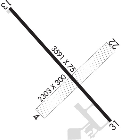
Runway Identification: 04/22Length: 2303 ft
Width: 300 ft
Surface: GRASS-GOOD CONDITION
Edge lights: Treatment: NONE
| | Runway: 04 | | Runway: 22 |
| Mag heading: | 43° | Mag heading: | 223° |
| Rwy Slope: | .10% Up | Rwy Slope: | -.10% Down |
| Approach: | | Approach: | |
| Pattern: | Left Traffic | Pattern: | Left Traffic |
| Markings: | | Markings: | |
| Marking Condition: | YELLOW CONES. | Marking Condition: | YELLOW CONES. |
| Arresting Dev: | | Arresting Dev: | |
| Lat & Long: | N4338.8 W09459.3 | Lat. & Long.: | N4339.1 W09459.0 |
| Elev: | 1440.5 ft. MSL | Elev: | 1442.7 ft. MSL |
| TCH: | | TCH: | |
| Visual Glide Path: | | Visual Glide Path: | |
| Displaced Threshold: | No | Displaced Threshold: | No |
| Touchdown Zone: | YES | Touchdown Zone: | YES |
| Touchdown Elev.: | 1443.4 feet | Touchdown Elev.: | 1443.4 feet |
| Visual Glide Slope: | | Visual Glide Slope: | |
| RVR Equipment: | | RVR Equipment: | |
| RVV Equipment: | NO | RVV Equipment: | NO |
| Approach Lights: | | Approach Lights: | |
| REIL: | NO | REIL: | NO |
| Centerline Lights: | NO | Centerline Lights: | NO |
| Touchdown lights: | NO | Touchdown lights: | NO |
| Runway Category: | Runway with a Visual Approach | Runway Category: | Runway with a Visual Approach |
| Declared Distances: | | Declared Distances: | |
| Obstructions: | TREE | Obstructions: | |
| Marked: | NOT Marked/Lighted | Marked: | |
| Clearance slope: | 19:1 | Clearance slope: | 20:1 |
| Obstruction height: | 9 feet AGL | Obstruction height: | |
| Dist. from runway: | 171 feet | Dist. from runway: | |
| Centerline offset: | 126 right of centerline | Centerline offset: | |
| Comments: | | Comments: | |
Runway Identification: 14/32Length: 4145 ft
Width: 75 ft
Surface: ASPHALT-FAIR CONDITION
Edge lights: Medium IntensityTreatment: NONE
| | Runway: 14 | | Runway: 32 |
| Mag heading: | 134° | Mag heading: | 314° |
| Rwy Slope: | .33% Up | Rwy Slope: | -.33% Down |
| Approach: | | Approach: | |
| Pattern: | Left Traffic | Pattern: | Left Traffic |
| Markings: | NONPRECISION INSTRUMENT | Markings: | NONPRECISION INSTRUMENT |
| Marking Condition: | FAIR | Marking Condition: | FAIR |
| Arresting Dev: | | Arresting Dev: | |
| Lat & Long: | N4339.3 W09459.5 | Lat. & Long.: | N4338.8 W09458.9 |
| Elev: | 1432.0 ft. MSL | Elev: | 1445.7 ft. MSL |
| TCH: | 26 ft. AGL | TCH: | 26 ft. AGL |
| Visual Glide Path: | 3.00 degrees | Visual Glide Path: | 3.00 degrees |
| Displaced Threshold: | 542 feet | Displaced Threshold: | 545 feet |
| Touchdown Zone: | YES | Touchdown Zone: | YES |
| Touchdown Elev.: | 1445.5 feet | Touchdown Elev.: | 1445.7 feet |
| Visual Glide Slope: | 4-Light PAPI on LEFT side of Runway | Visual Glide Slope: | 4-Light PAPI on LEFT side of Runway |
| RVR Equipment: | | RVR Equipment: | |
| RVV Equipment: | NO | RVV Equipment: | NO |
| Approach Lights: | | Approach Lights: | |
| REIL: | YES | REIL: | YES |
| Centerline Lights: | NO | Centerline Lights: | NO |
| Touchdown lights: | NO | Touchdown lights: | NO |
| Runway Category: | Runway with a Non-precision Approach | Runway Category: | Runway with a Non-precision Approach |
| Declared Distances: | | Declared Distances: | |
| Obstructions: | | Obstructions: | ROAD |
| Marked: | | Marked: | NOT Marked/Lighted |
| Clearance slope: | 20:1 | Clearance slope: | 15:1 |
| Obstruction height: | | Obstruction height: | 15 feet AGL |
| Dist. from runway: | | Dist. from runway: | 435 feet |
| Centerline offset: | | Centerline offset: | 267 feet left of centerline |
| Comments: | | Comments: | |

