Current Weather/Notams (Metars, TAFs, Notams, NWS Forecast, PIREPS, and nearby weather)
Customs Information Send updates to Support@FltPlan.com
Customs Not Available
Database effective 04/18/2024
Airport Diagram might not be current.
|
| Facility Name: | MILLVILLE MUNI |
| City Name: | MILLVILLE |
| County: | CUMBERLAND |
| State abbrev: | NJ |
| State Name: | NEW JERSEY |
| | |
| Ownership: | PUBLICLY OWNED |
| Use: | OPEN TO THE PUBLIC |
| Owner's Name: | DRBA-CITY OF MILLVILLE |
| Address: | 104 LEDDON STREET |
| | MILLVILLE, NJ 08332 |
| Owner's Phone: | 856-825-1244 |
| | |
| Manager's Name: | JOE MULHERON |
| Address: | ADMIN BLDG, 104 LEDDON ST |
| | MILLVILLE, NJ 08332 |
| Phone: | 856-825-1244 |
| | |
| FAA Region: | EASTERN |
| FAA Field Office: | HAR |
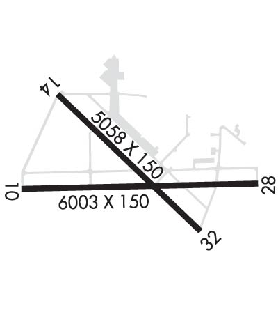
Runway Identifications
Runway Identification: 10/28Length: 6003 ft
Width: 150 ft
Surface: ASPHALT-GOOD CONDITION
Edge lights: Medium IntensityTreatment: GROOVED
Weight: PCN 55 /F/D/W/T
| | Runway: 10 | | Runway: 28 |
| Mag heading: | 101° | Mag heading: | 281° |
| Rwy Slope: | .18% Up | Rwy Slope: | -.18% Down |
| Approach: | ILS | Approach: | |
| Pattern: | Left Traffic | Pattern: | Left Traffic |
| Markings: | PRECISION INSTRUMENT | Markings: | NONPRECISION INSTRUMENT |
| Marking Condition: | GOOD | Marking Condition: | GOOD |
| Arresting Dev: | | Arresting Dev: | |
| Lat & Long: | N3922.0 W07504.9 | Lat. & Long.: | N3922.0 W07503.7 |
| Elev: | 73.5 ft. MSL | Elev: | 84.4 ft. MSL |
| TCH: | 53 ft. AGL | TCH: | 29 ft. AGL |
| Visual Glide Path: | 3.00 degrees | Visual Glide Path: | 3.00 degrees |
| Displaced Threshold: | No | Displaced Threshold: | No |
| Touchdown Zone: | YES | Touchdown Zone: | YES |
| Touchdown Elev.: | 73.5 feet | Touchdown Elev.: | 84.6 feet |
| Visual Glide Slope: | 4-Light PAPI on LEFT side of Runway | Visual Glide Slope: | 4-Light PAPI on LEFT side of Runway |
| RVR Equipment: | | RVR Equipment: | |
| RVV Equipment: | NO | RVV Equipment: | NO |
| Approach Lights: | MALSR - 1,400 foot medium intensity approach lighting system with runway alignment indicator lights | Approach Lights: | |
| REIL: | NO | REIL: | NO |
| Centerline Lights: | NO | Centerline Lights: | NO |
| Touchdown lights: | NO | Touchdown lights: | NO |
| Runway Category: | Precision Instrument Runway | Runway Category: | Runway with a Non-precision Approach having visibility minimums greater than 3/4 mile |
| Declared Distances: | | Declared Distances: | |
| Obstructions: | TREES | Obstructions: | |
| Marked: | NOT Marked/Lighted | Marked: | |
| Clearance slope: | 35:1 | Clearance slope: | 34:1 |
| Obstruction height: | 65 feet AGL | Obstruction height: | |
| Dist. from runway: | 2480 feet | Dist. from runway: | |
| Centerline offset: | 170 left of centerline | Centerline offset: | |
| Comments: | | Comments: | |
Runway Identification: 14/32Length: 5058 ft
Width: 150 ft
Surface: CONCRETE-GOOD CONDITION
Edge lights: Medium IntensityTreatment: NONE
| | Runway: 14 | | Runway: 32 |
| Mag heading: | 146° | Mag heading: | 326° |
| Rwy Slope: | .03% Up | Rwy Slope: | -.03% Down |
| Approach: | | Approach: | |
| Pattern: | Left Traffic | Pattern: | Left Traffic |
| Markings: | NONPRECISION INSTRUMENT | Markings: | NONPRECISION INSTRUMENT |
| Marking Condition: | GOOD | Marking Condition: | GOOD |
| Arresting Dev: | | Arresting Dev: | |
| Lat & Long: | N3922.4 W07504.7 | Lat. & Long.: | N3921.8 W07504.0 |
| Elev: | 80.7 ft. MSL | Elev: | 82.2 ft. MSL |
| TCH: | 48 ft. AGL | TCH: | 39 ft. AGL |
| Visual Glide Path: | 3.00 degrees | Visual Glide Path: | 3.00 degrees |
| Displaced Threshold: | No | Displaced Threshold: | No |
| Touchdown Zone: | YES | Touchdown Zone: | YES |
| Touchdown Elev.: | 80.8 feet | Touchdown Elev.: | 82.2 feet |
| Visual Glide Slope: | 4-Light PAPI on LEFT side of Runway | Visual Glide Slope: | 4-Light PAPI on LEFT side of Runway |
| RVR Equipment: | | RVR Equipment: | |
| RVV Equipment: | NO | RVV Equipment: | NO |
| Approach Lights: | | Approach Lights: | |
| REIL: | NO | REIL: | NO |
| Centerline Lights: | NO | Centerline Lights: | NO |
| Touchdown lights: | NO | Touchdown lights: | NO |
| Runway Category: | Runway with a Non-precision Approach having visibility minimums greater than 3/4 mile | Runway Category: | Runway with a Non-precision Approach having visibility minimums greater than 3/4 mile |
| Declared Distances: | | Declared Distances: | |
| Obstructions: | TREES | Obstructions: | TREES |
| Marked: | NOT Marked/Lighted | Marked: | NOT Marked/Lighted |
| Clearance slope: | 40:1 | Clearance slope: | 20:1 |
| Obstruction height: | 49 feet AGL | Obstruction height: | 55 feet AGL |
| Dist. from runway: | 2160 feet | Dist. from runway: | 1335 feet |
| Centerline offset: | 190 left of centerline | Centerline offset: | |
| Comments: | | Comments: | |

