Current Weather/Notams (Metars, TAFs, Notams, NWS Forecast, PIREPS, and nearby weather)
Customs Information Send updates to Support@FltPlan.com
Customs Not Available
Database effective 05/16/2024
Airport Diagram might not be current.
|
| Facility Name: | DELAWARE COUNTY RGNL |
| City Name: | MUNCIE |
| County: | DELAWARE |
| State abbrev: | IN |
| State Name: | INDIANA |
| | |
| Ownership: | PUBLICLY OWNED |
| Use: | OPEN TO THE PUBLIC |
| Owner's Name: | DELAWARE COUNTY ARPT AUTH |
| Address: | 311 W. CARL SIMMONS RD. |
| | MUNCIE, IN 47303 |
| Owner's Phone: | 765-747-5690 |
| | |
| Manager's Name: | TIM BATY |
| Address: | 311 W. CARL SIMMONS RD. |
| | MUNCIE, IN 47303 |
| Phone: | 765-747-5690; 765-729-1078 |
| | |
| FAA Region: | GREAT LAKES |
| FAA Field Office: | CHI |
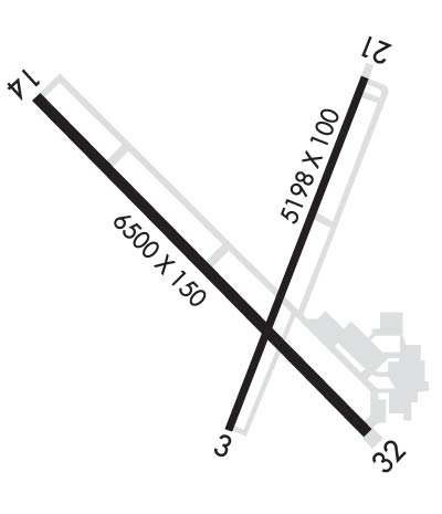
Runway Identifications
Runway Identification: 03/21Length: 5198 ft
Width: 100 ft
Surface: ASPHALT-FAIR CONDITION
Edge lights: Medium IntensityTreatment: GROOVED
Weight: PCN 32 /F/C/X/T
| | Runway: 03 | | Runway: 21 |
| Mag heading: | 25° | Mag heading: | 205° |
| Rwy Slope: | -.05% Down | Rwy Slope: | .05% Up |
| Approach: | | Approach: | |
| Pattern: | Left Traffic | Pattern: | Left Traffic |
| Markings: | NONPRECISION INSTRUMENT | Markings: | NONPRECISION INSTRUMENT |
| Marking Condition: | FAIR | Marking Condition: | FAIR |
| Arresting Dev: | | Arresting Dev: | |
| Lat & Long: | N4014.2 W08523.8 | Lat. & Long.: | N4015.0 W08523.4 |
| Elev: | 937.3 ft. MSL | Elev: | 934.7 ft. MSL |
| TCH: | 39 ft. AGL | TCH: | 45 ft. AGL |
| Visual Glide Path: | 3.00 degrees | Visual Glide Path: | 3.00 degrees |
| Displaced Threshold: | No | Displaced Threshold: | No |
| Touchdown Zone: | YES | Touchdown Zone: | YES |
| Touchdown Elev.: | 937.3 feet | Touchdown Elev.: | 935.0 feet |
| Visual Glide Slope: | 4-Light PAPI on LEFT side of Runway | Visual Glide Slope: | 4-Light PAPI on LEFT side of Runway |
| RVR Equipment: | | RVR Equipment: | |
| RVV Equipment: | NO | RVV Equipment: | NO |
| Approach Lights: | | Approach Lights: | |
| REIL: | YES | REIL: | YES |
| Centerline Lights: | NO | Centerline Lights: | NO |
| Touchdown lights: | NO | Touchdown lights: | NO |
| Runway Category: | Runway with a Visual Approach | Runway Category: | Runway with a Non-precision Approach having visibility minimums greater than 3/4 mile |
| Declared Distances: | TORA:5197' TODA:5197' ASDA:5197' LDA:5197' | Declared Distances: | TORA:5197' TODA:5197' ASDA:5197' LDA:5197' |
| Obstructions: | TREE | Obstructions: | TREE |
| Marked: | NOT Marked/Lighted | Marked: | NOT Marked/Lighted |
| Clearance slope: | 23:1 | Clearance slope: | 25:1 |
| Obstruction height: | 58 feet AGL | Obstruction height: | 44 feet AGL |
| Dist. from runway: | 1570 feet | Dist. from runway: | 1281 feet |
| Centerline offset: | 241 left of centerline | Centerline offset: | 424 feet left of centerline |
| Comments: | | Comments: | |
Runway Identification: 14/32Length: 6500 ft
Width: 150 ft
Surface: ASPHALT-GOOD CONDITION
Edge lights: High IntensityTreatment: GROOVED
Weight: PCN 36 /F/C/W/T
| | Runway: 14 | | Runway: 32 |
| Mag heading: | 139° | Mag heading: | 319° |
| Rwy Slope: | .12% Up | Rwy Slope: | -.12% Down |
| Approach: | | Approach: | ILS |
| Pattern: | Left Traffic | Pattern: | Left Traffic |
| Markings: | PRECISION INSTRUMENT | Markings: | PRECISION INSTRUMENT |
| Marking Condition: | FAIR | Marking Condition: | FAIR |
| Arresting Dev: | | Arresting Dev: | |
| Lat & Long: | N4014.9 W08524.4 | Lat. & Long.: | N4014.2 W08523.4 |
| Elev: | 928.6 ft. MSL | Elev: | 936.4 ft. MSL |
| TCH: | 49 ft. AGL | TCH: | |
| Visual Glide Path: | 3.00 degrees | Visual Glide Path: | |
| Displaced Threshold: | No | Displaced Threshold: | No |
| Touchdown Zone: | YES | Touchdown Zone: | YES |
| Touchdown Elev.: | 933.4 feet | Touchdown Elev.: | 936.5 feet |
| Visual Glide Slope: | 4-Light PAPI on LEFT side of Runway | Visual Glide Slope: | |
| RVR Equipment: | | RVR Equipment: | |
| RVV Equipment: | NO | RVV Equipment: | NO |
| Approach Lights: | | Approach Lights: | MALSR - 1,400 foot medium intensity approach lighting system with runway alignment indicator lights |
| REIL: | YES | REIL: | NO |
| Centerline Lights: | NO | Centerline Lights: | NO |
| Touchdown lights: | NO | Touchdown lights: | NO |
| Runway Category: | Runway with a Non-precision Approach having visibility minimums greater than 3/4 mile | Runway Category: | Precision Instrument Runway |
| Declared Distances: | TORA:6500' TODA:6500' ASDA:6500' LDA:6500' | Declared Distances: | TORA:6500' TODA:6500' ASDA:6500' LDA:6500' |
| Obstructions: | TREES | Obstructions: | TREES |
| Marked: | NOT Marked/Lighted | Marked: | NOT Marked/Lighted |
| Clearance slope: | 40:1 | Clearance slope: | 39:1 |
| Obstruction height: | 98 feet AGL | Obstruction height: | 73 feet AGL |
| Dist. from runway: | 4200 feet | Dist. from runway: | 3066 feet |
| Centerline offset: | 50 right of centerline | Centerline offset: | 857 feet left of centerline |
| Comments: | | Comments: | |

