Current Weather/Notams (Metars, TAFs, Notams, NWS Forecast, PIREPS, and nearby weather)
Customs Information Send updates to Support@FltPlan.com
Customs Not Available
Database effective 05/16/2024
Airport Diagram might not be current.
|
| Facility Name: | CRYSTAL |
| City Name: | MINNEAPOLIS |
| County: | HENNEPIN |
| State abbrev: | MN |
| State Name: | MINNESOTA |
| | |
| Ownership: | PUBLICLY OWNED |
| Use: | OPEN TO THE PUBLIC |
| Owner's Name: | METROPOLITAN AIRPORT CMSN |
| Address: | 6040 28TH AVE S |
| | MINNEAPOLIS, MN 55450-2799 |
| Owner's Phone: | 612-726-8100 |
| | |
| Manager's Name: | SAM SEAFELDT; SAM.SEAFELDT@MSPMAC.ORG |
| Address: | 5800 CRYSTAL AIRPORT RD |
| | MINNEAPOLIS, MN 55429-2364 |
| Phone: | 612-726-8140 |
| | |
| FAA Region: | GREAT LAKES |
| FAA Field Office: | DMA |
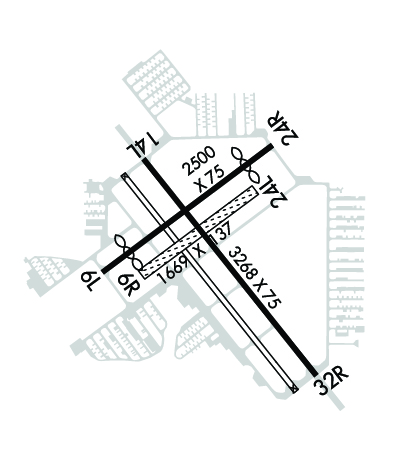
Runway Identifications
Runway Identification: 06L/24RLength: 2500 ft
Width: 75 ft
Surface: ASPHALT-GOOD CONDITION
Edge lights: Medium IntensityTreatment: NONE
| | Runway: 06L | | Runway: 24R |
| Mag heading: | 51° | Mag heading: | 231° |
| Rwy Slope: | -.08% Down | Rwy Slope: | .08% Up |
| Approach: | | Approach: | |
| Pattern: | Left Traffic | Pattern: | Left Traffic |
| Markings: | BASIC | Markings: | BASIC |
| Marking Condition: | GOOD | Marking Condition: | GOOD |
| Arresting Dev: | | Arresting Dev: | |
| Lat & Long: | N4503.7 W09321.5 | Lat. & Long.: | N4503.9 W09321.1 |
| Elev: | 869.2 ft. MSL | Elev: | 867.1 ft. MSL |
| TCH: | 27 ft. AGL | TCH: | 29 ft. AGL |
| Visual Glide Path: | 4.00 degrees | Visual Glide Path: | 3.50 degrees |
| Displaced Threshold: | 390 feet | Displaced Threshold: | 389 feet |
| Touchdown Zone: | YES | Touchdown Zone: | YES |
| Touchdown Elev.: | 869.3 feet | Touchdown Elev.: | 869.3 feet |
| Visual Glide Slope: | 4-BOX VASI ON LEFT SIDE OF RUNWAY | Visual Glide Slope: | 4-BOX VASI ON LEFT SIDE OF RUNWAY |
| RVR Equipment: | | RVR Equipment: | |
| RVV Equipment: | NO | RVV Equipment: | NO |
| Approach Lights: | | Approach Lights: | |
| REIL: | NO | REIL: | NO |
| Centerline Lights: | NO | Centerline Lights: | NO |
| Touchdown lights: | NO | Touchdown lights: | NO |
| Runway Category: | Runway with a Visual Approach | Runway Category: | Runway with a Visual Approach |
| Declared Distances: | TORA:2500' TODA:2500' ASDA:2500' LDA:2110' | Declared Distances: | TORA:2500' TODA:2500' ASDA:2500' LDA:2111' |
| Obstructions: | TREE | Obstructions: | TREE |
| Marked: | NOT Marked/Lighted | Marked: | NOT Marked/Lighted |
| Clearance slope: | 14:1; 23:1 TO DTHR. | Clearance slope: | 12:1; 21:1 TO DTHR. |
| Obstruction height: | 67 feet AGL | Obstruction height: | 60 feet AGL |
| Dist. from runway: | 1160 feet | Dist. from runway: | 973 feet |
| Centerline offset: | 198 right of centerline | Centerline offset: | 2 feet right of centerline |
| Comments: | | Comments: | |
Runway Identification: 06R/24LLength: 1669 ft
Width: 137 ft
Surface: GRASS-FAIR CONDITION
Edge lights: Treatment: NONE
| | Runway: 06R | | Runway: 24L |
| Mag heading: | 51° | Mag heading: | 231° |
| Rwy Slope: | -.12% Down | Rwy Slope: | .12% Up |
| Approach: | | Approach: | |
| Pattern: | Left Traffic | Pattern: | Left Traffic |
| Markings: | | Markings: | |
| Marking Condition: | GOOD; YELLOW CONES. | Marking Condition: | GOOD; YELLOW CONES. |
| Arresting Dev: | | Arresting Dev: | |
| Lat & Long: | N4503.7 W09321.4 | Lat. & Long.: | N4503.8 W09321.1 |
| Elev: | 869.0 ft. MSL | Elev: | 867.0 ft. MSL |
| TCH: | | TCH: | |
| Visual Glide Path: | | Visual Glide Path: | |
| Displaced Threshold: | No | Displaced Threshold: | No |
| Touchdown Zone: | YES | Touchdown Zone: | YES |
| Touchdown Elev.: | 869.0 feet | Touchdown Elev.: | 869.0 feet |
| Visual Glide Slope: | | Visual Glide Slope: | |
| RVR Equipment: | | RVR Equipment: | |
| RVV Equipment: | NO | RVV Equipment: | NO |
| Approach Lights: | | Approach Lights: | |
| REIL: | NO | REIL: | NO |
| Centerline Lights: | NO | Centerline Lights: | NO |
| Touchdown lights: | NO | Touchdown lights: | NO |
| Runway Category: | Runway with a Visual Approach | Runway Category: | Runway with a Visual Approach |
| Declared Distances: | | Declared Distances: | |
Runway Identification: 14/32Length: 3751 ft
Width: 75 ft
Surface: ASPHALT
Edge lights: Medium IntensityTreatment: NONE
| | Runway: 14 | | Runway: 32 |
| Mag heading: | 139° | Mag heading: | 319° |
| Rwy Slope: | -.03% Down | Rwy Slope: | .03% Up |
| Approach: | | Approach: | |
| Pattern: | Left Traffic | Pattern: | Left Traffic |
| Markings: | NONPRECISION INSTRUMENT | Markings: | NONPRECISION INSTRUMENT |
| Marking Condition: | GOOD | Marking Condition: | GOOD |
| Arresting Dev: | | Arresting Dev: | |
| Lat & Long: | N4503.9 W09321.5 | Lat. & Long.: | N4503.5 W09320.9 |
| Elev: | 868.5 ft. MSL | Elev: | 867.2 ft. MSL |
| TCH: | 37 ft. AGL | TCH: | 35 ft. AGL |
| Visual Glide Path: | 4.00 degrees | Visual Glide Path: | 4.00 degrees |
| Displaced Threshold: | 241 feet | Displaced Threshold: | 241 feet |
| Touchdown Zone: | YES | Touchdown Zone: | YES |
| Touchdown Elev.: | 868.6 feet | Touchdown Elev.: | 868.6 feet |
| Visual Glide Slope: | 4-Light PAPI on LEFT side of Runway | Visual Glide Slope: | 4-Light PAPI on LEFT side of Runway |
| RVR Equipment: | | RVR Equipment: | |
| RVV Equipment: | NO | RVV Equipment: | NO |
| Approach Lights: | | Approach Lights: | |
| REIL: | YES | REIL: | YES |
| Centerline Lights: | NO | Centerline Lights: | NO |
| Touchdown lights: | NO | Touchdown lights: | NO |
| Runway Category: | Runway with a Non-precision Approach | Runway Category: | Runway with a Non-precision Approach |
| Declared Distances: | TORA:3509' TODA:3509' ASDA:3750' LDA:3508' | Declared Distances: | TORA:3508' TODA:3508' ASDA:3750' LDA:3509' |
| Obstructions: | TREE | Obstructions: | TREES |
| Marked: | NOT Marked/Lighted | Marked: | NOT Marked/Lighted |
| Clearance slope: | 15:1; CLNC SLP 23:1 TO DTHR. | Clearance slope: | 15:1; CLNC SLP 25:1 TO DTHR. |
| Obstruction height: | 57 feet AGL | Obstruction height: | 48 feet AGL |
| Dist. from runway: | 1103 feet | Dist. from runway: | 944 feet |
| Centerline offset: | 2 left of centerline | Centerline offset: | 297 feet right of centerline |
| Comments: | | Comments: | |


