Click here for more info on on SMS!

KMHT

MANCHESTER
MANCHESTER
NH
Time Zone: Eastern
Lat: N 4256.0
Long: W 07126.1
Elev: 266
Var: +15
Longest Runway: 9250
Clr Del: 135.9
Dept. ATIS: 119.55
Arr. ATIS: 119.55
AWOS: 119.55
Ground: 121.9
Tower: 121.3

FBO & Flight Services info for KMHT

FBOs: Update your Fuel Prices

SIGNATUREPh: 603-782-0151 Fax: 603-621-0030 Freq: 130.32
Service
Jet
100LL
SAF
MoGas
Fuel Avail: Jet A w/Prist, add $0.04 per gallon.
Full6.937.79    Last Update: 04/19/2024 07:53

Self        
 Address: 1 GARSIDE WAY   MANCHESTER, NH 03103
ASOSPh: 603-668-8992
-
Freq: 119.55  
If you are an FBO, call 1-203-262-1700 to update your info or email: FltPlan.Advertising@garmin.com
Advertise your FBO on FltPlan.com

Runway & Approach Info for KMHT
Rwy
Length
Land Dist**
Approach*
  Rwy
Length
Land Dist**
Approach*
06
7651x150  7209'          
ILS
 109.95 - 057°  
  
24
  7651x150  7651'          
 
17
9250x150  8914'          
ILS/DME
 109.10 - 171°  
  
35
  9250x150  8400'          
ILS/DME
 109.10 - 351°  
 * only ILS, LOC, LDA, and SDF approaches to a specific runway are shown
** For any Declared Landing Distance Available, please see A/FD or Approach plates
Runway Weight Capability (lbs.) Help
Runway IDSingle WheelDouble WheelDouble Tandem WheelDual Double Wheel
06/24200,000300,000350,000N/A
17/35200,000300,000350,000N/A
These numbers are Advisory and are not limits.   The Airport Manager should have more accurate Weight Limits
Approach Charts
Approaches    
Current Weather/Notams
Customs Information Send updates to Support@FltPlan.com
Phone 603-836-0722
Fax 603-836-0703

Comments 3 hrs advance notice required. Business hrs 1000-1800 Monday-Friday. *Maximum passengers per flight: 15 *Call prior to 1700 for after hours/weekend .
Database effective 04/18/2024
Airport Diagram of KMHT
Airport Diagram might not be current.

Facility Name: MANCHESTER BOSTON RGNL
City Name: MANCHESTER
County: HILLSBOROUGH
State abbrev: NH
State Name: NEW HAMPSHIRE
   
Ownership: PUBLICLY OWNED
Use: OPEN TO THE PUBLIC
Owner's Name: CITY OF MANCHESTER
Address: CITY HALL
 MANCHESTER, NH 03101
Owner's Phone: 603-624-6539
  
Manager's Name: THEODORE KITCHENS
Address: 1 AIRPORT RD SUITE 300
 MANCHESTER, NH 03103
Phone: 603-624-6539
   
FAA Region: NEW ENGLAND
FAA Field Office: NONE


Sunrise / Sunset times for MANCHESTER BOSTON RGNL

DateSunriseSunset
04/18/24 Thursday5:5819:33
04/19/24 Friday5:5619:34
04/20/24 Saturday5:5519:35
04/21/24 Sunday5:5319:36
04/22/24 Monday5:5219:37
04/23/24 Tuesday5:5019:38
04/24/24 Wednesday5:4919:39
04/25/24 Thursday5:4719:41
04/26/24 Friday5:4619:42
04/27/24 Saturday5:4419:43
04/28/24 Sunday5:4319:44
04/29/24 Monday5:4119:45
04/30/24 Tuesday5:4019:46
05/01/24 Wednesday5:3919:47

Airport Facilities

Airport Attendance ScheduleCONTINUOUS
Airport Status OPERATIONAL (This Status can change at any time - please check NOTAMS)
Airport Lighting ScheduleSS-SR
Airport Storage AvailableTie Downs, Hanger
Extra Services AvailableAir Freight, Avionics, Charter, Flight Instruction, Aircraft Rental
Wind IndicatorYES - (lighted)
Control TowerYES
CTAF Frequency
Unicom Frequency122.950
Rotating Beacon ColorWG
Segmented CircleNO
Landing FeeYES

Airport Inspection Data

Airport InspectedFEDERAL - performed by FAA AIRPORTS FIELD PERSONNEL
Inspection Date11/17/2022

Airport Services

Type of Fuel AvailableGrade 100LL, JET A (freeze point -40C)
Airframe Repair ServiceMAJOR
Power Plant Repair ServiceMAJOR

Geographic Data

LatitudeN4256.0
LongitudeW07126.1 (ESTIMATED)
Arpt Elevation266ft (SURVEYED)
Magnetic Variation15W
3 miles Sof MANCHESTER
Traffic Pattern Altitude
Sectional ChartNEW YORK

Aircraft Data

Operations (Reported)YearlyAvg. Daily
General Aviation Transient 1405539
General Aviation Local 525514
Air Taxi 1023028
Commerical 1729747
Commuter 00
Military 7022
Aircraft based on Field
General Aviation Singles 52
General Aviation Multi 27
Jet Aircraft 13
General Aviation Helicopters 5
Military Aircraft 0
Gliders 0
Ultralights 0

FAA Services

FSS on field NO
FSS tie-in BANGOR
FSS Phone 1-800-WX-BRIEF
Who issues Notams MHT
Notam D service at airport YES
ARTCC Name BOSTON

Federal Status

Airport CertificationAIRPORT RECEIVING SCHEDULED AIR CARRIER SERVICE FROM CARRIERS CERTIFICATED BY THE CIVIL AERONAUTICS BOARD
Aircraft Rescue & Firefighting IndexAIRPORT HAS A CERTIFICATE UNDER CFR PART 139
Airport of EntryNo
Custom Landing RightsNo; US CUSTOMS USER FEE ARPT.
Joint Civil/MilitaryNo
Military Landing rightsYES

Federal Agreements

NATIONAL PLAN OF INTEGRATED AIRPORT SYSTEMS (NPIAS)
GRANT AGREEMENTS UNDER FAAP/ADAP/AIP
SURPLUS PROPERTY AGREEMENT UNDER PUBLIC LAW 289
ASSURANCES PURSUANT TO TITLE VI, CIVIL RIGHTS ACT OF 1964

Remarks

AIR CARRIER ACFT ONLY PERMITTED TO OPR ON AIRLINE TERMINAL RAMP.
JET ACFT TAXIING WB ACRS RWY 17/35 AT TWY E MUST USE CTN & LOW SETTINGS DUE TO LGT ACFT PRKG ON E RAMP.
NO TAXIING BTWN PUSHED BACK ACFT & THE AIRLINE TERMINAL OR CARGO RAMPS.
AIR CARRIERS EXCLUDED FM OPERATING ON TWY L.
TWY A SAFETY AREA S OF TWY E TO TWY A2 IS 65 FT.
ACFT WITH WINGSPAN GREATER THAN 145 FT RSTRD FM TWY G AND TWY N.
AMMON RAMP RSTRD TO ACFT WITH WINGSPAN LESS THAN 118 FT. ACFT ARE REQ TO MNTN TAXILANE CNTRLN TO AVOID PARKED GA ACFT TIEDOWNS. ACFT WITH WINGSPAN 118 FT OR GTR REQ GND CREW ASSISTANCE FOR TAXI & PRKG.
NO TGLS PERMITTED DURG SNOW REMOVAL OPNS.
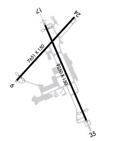
NOISE ABATEMENT PROCEDURES: TURBOJET ACFT SHOULD EXPECT A RIGHT TURN WHEN DEPARTING RY 17.
ACFT NOT PERMITTED TO TAXI BETWEEN AIRLINE TERMINAL BLDG & ACFT THAT HAVE PUSHED BACK OR ARE TAXIING ON TWY G OR N.
Airport Communications & Frequencies:
ATIS Frequencies:   Hours(local) of Operation: CONTINUOUS
119.55
MANCHESTER Tower Frequencies:   Hours(local) of operation: CONTINUOUS   
121.3
239.025
MANCHESTER Ground Frequencies:
121.9
Clearance Delivery Frequencies:
135.9
Emergency Frequencies:
121.5
243.0
Unicom Frequency:
122.950
Remarks
  • NOTE: FREQS 124.9 AND 305.4 ARE PHYSICALLY LCTD IN THE BOSTON ARTCC; FREQ 127.75 IS LCTD AT THE RADAR SITE AT NASHUA, NH.
  • BOSTON Primary Approach Frequencies:  
    124.9
    269.075
    BOSTON Primary Departure Frequencies:  
    124.9
    269.075
    Class C Frequencies:
    124.9 MANCHESTER/CONCORD AREA
    125.05 NH SEACOAST AREA
    134.75 NH LAKES REGION
    Runway Identifications
    Runway Identification: 06/24
    Length: 7651 ft
    Width: 150 ft
    Surface: ASPHALT-FAIR CONDITION
    Edge lights: High Intensity

    Treatment: GROOVED
    Weight: PCN 90 /F/C/W/T

     Runway: 06   Runway: 24
    Mag heading: 57°Mag heading: 237°
    Rwy Slope: .27% UpRwy Slope: -.27% Down
    Approach: ILSApproach:
    Pattern: Left TrafficPattern: Left Traffic
    Markings: PRECISION INSTRUMENTMarkings: NONPRECISION INSTRUMENT
    Marking Condition: GOODMarking Condition: GOOD
    Arresting Dev: EMAS; ENGINEERED MATERIALS ARRESTING SYSTEM (EMAS) 300 FT IN LENGTH BY 170 FT IN WIDTH LCTD AT THE DER 06.Arresting Dev:
    Lat & Long: N4255.7  W07126.9Lat. & Long.: N4256.6  W07125.8
    Elev: 220.9 ft. MSLElev: 241.5 ft. MSL
    TCH: 50 ft. AGLTCH: 50 ft. AGL
    Visual Glide Path: 3.00 degreesVisual Glide Path: 3.00 degrees
    Displaced Threshold: 442 feetDisplaced Threshold: No
    Touchdown Zone: YESTouchdown Zone: YES
    Touchdown Elev.: 223.7 feetTouchdown Elev.: 241.5 feet
    Visual Glide Slope: 4-Light PAPI on LEFT side of Runway; PAPI UNUSBL BYD 6 DEGS R OF CNTRLN.Visual Glide Slope: 4-Light PAPI on LEFT side of Runway
    RVR Equipment: TOUCHDOWN-ROLLOUTRVR Equipment: TOUCHDOWN-ROLLOUT
    RVV Equipment: NORVV Equipment: NO
    Approach Lights: Approach Lights:
    REIL: YESREIL: YES
    Centerline Lights: YESCenterline Lights: YES
    Touchdown lights: NOTouchdown lights: NO
    Runway Category: Precision Instrument RunwayRunway Category: Precision Instrument Runway
    Declared Distances: TORA:7650' TODA:7650' ASDA:7650' LDA:7208'Declared Distances: TORA:7650' TODA:7650' ASDA:6850' LDA:6850'
    Obstructions: TREESObstructions: TREES
    Marked: NOT Marked/LightedMarked: NOT Marked/Lighted
    Clearance slope: 40:1Clearance slope: 25:1
    Obstruction height: 61 feet AGLObstruction height: 52 feet AGL
    Dist. from runway: 2667 feetDist. from runway: 1500 feet
    Centerline offset: 470 left of centerlineCenterline offset: 75 feet left of centerline
    Comments: Comments:
    Runway Identification: 17/35
    Length: 9250 ft
    Width: 150 ft
    Surface: ASPHALT-FAIR CONDITION
    Edge lights: High Intensity

    Treatment: GROOVED
    Weight: PCN 90 /F/C/W/T

     Runway: 17   Runway: 35
    Mag heading: 172°Mag heading: 352°
    Rwy Slope: .54% UpRwy Slope: -.54% Down
    Approach: ILS/DMEApproach: ILS/DME
    Pattern: Left TrafficPattern: Left Traffic
    Markings: PRECISION INSTRUMENTMarkings: PRECISION INSTRUMENT
    Marking Condition: GOODMarking Condition: GOOD
    Arresting Dev: Arresting Dev:
    Lat & Long: N4256.5  W07126.4Lat. & Long.: N4255.1  W07125.5
    Elev: 216.1 ft. MSLElev: 266.4 ft. MSL
    TCH: 67 ft. AGLTCH: 68 ft. AGL
    Visual Glide Path: 3.10 degreesVisual Glide Path: 3.00 degrees
    Displaced Threshold: 336 feetDisplaced Threshold: 850 feet
    Touchdown Zone: YESTouchdown Zone: YES
    Touchdown Elev.: 229.1 feetTouchdown Elev.: 265.4 feet
    Visual Glide Slope: 4-Light PAPI on RIGHT side of RunwayVisual Glide Slope: 4-Light PAPI on LEFT side of Runway
    RVR Equipment: TOUCHDOWN-MIDFIELD-ROLLOUTRVR Equipment: TOUCHDOWN-MIDFIELD-ROLLOUT
    RVV Equipment: NORVV Equipment: NO
    Approach Lights: MALSR - 1,400 foot medium intensity approach lighting system with runway alignment indicator lightsApproach Lights: ALSF2 - standard 2,400 foot high intensity approach lighting system with sequenced flashers, Category II or III
    REIL: NOREIL: NO
    Centerline Lights: YESCenterline Lights: YES
    Touchdown lights: YESTouchdown lights: YES
    Runway Category: Precision Instrument RunwayRunway Category: Precision Instrument Runway
    Declared Distances: TORA:9250' TODA:9250' ASDA:9250' LDA:8914'Declared Distances: TORA:9250' TODA:9250' ASDA:8500' LDA:7650'
    Obstructions: POLEObstructions: BLDG
    Marked: NOT Marked/LightedMarked: NOT Marked/Lighted
    Clearance slope: 34:1Clearance slope: 50:1
    Obstruction height: 71 feet AGLObstruction height: 53 feet AGL
    Dist. from runway: 2600 feetDist. from runway: 3025 feet
    Centerline offset: 125 left of centerlineCenterline offset: 75 feet right of centerline
    Comments: Comments:
    C:59/P: