
| |||||||||||||||||||||||||||||||||||||||||||||||||||||||||||||||||||||
| |||||||||||||||||||||||||||||||||||||||||||||||||||||||||||||||||||||
| |||||||||||||||||||||||||||||||||||||||||||||||||||||||||||||||||||||
| FBOs at nearby airports who want your business: | |||||||||||
| |||||||||||
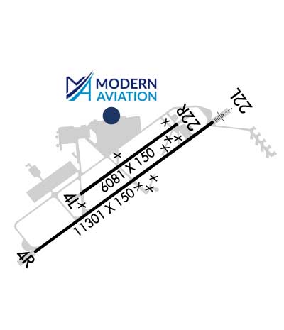
| Rwy | Rwy | |||||||
| 6081x150 | 6081' | 6081x150 | 6081' | |||||
| 11301x150 | 11301' | 11301x150 | 11301' | 111.35 - 220° | ||||
| Runway ID | Single Wheel | Double Wheel | Double Tandem Wheel | Dual Double Wheel |
| 04L/22R | 90,000 | 105,000 | 190,000 | N/A |
| 04R/22L | 160,000 | 280,000 | 500,000 | N/A |
| H1 | N/A | N/A | N/A | N/A |
| H2 | N/A | N/A | N/A | N/A |
| These numbers are Advisory and are not limits. The Airport Manager should have more accurate Weight Limits | ||||
 Airport Diagram might not be current. | |
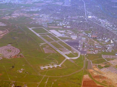
| Facility Name: | SACRAMENTO MATHER |
| City Name: | SACRAMENTO |
| County: | SACRAMENTO |
| State abbrev: | CA |
| State Name: | CALIFORNIA |
| Ownership: | PUBLICLY OWNED |
| Use: | OPEN TO THE PUBLIC |
| Owner's Name: | COUNTY OF SACRAMENTO |
| Address: | 6900 AIRPORT BLVD. |
| SACRAMENTO, CA 95837 | |
| Owner's Phone: | 916-875-7077 |
| Manager's Name: | LARRY FLESHMAN |
| Address: | 10425 NORDEN AVE |
| MATHER, CA 95655 | |
| Phone: | 916-875-6760 |
| FAA Region: | WESTERN-PACIFIC |
| FAA Field Office: | SFO |
| Date | Sunrise | Sunset |
|---|---|---|
| 04/26/24 Friday | 6:13 | 19:53 |
| 04/27/24 Saturday | 6:12 | 19:54 |
| 04/28/24 Sunday | 6:11 | 19:55 |
| 04/29/24 Monday | 6:09 | 19:56 |
| 04/30/24 Tuesday | 6:08 | 19:57 |
| 05/01/24 Wednesday | 6:07 | 19:58 |
| 05/02/24 Thursday | 6:06 | 19:59 |
| 05/03/24 Friday | 6:05 | 20:00 |
| 05/04/24 Saturday | 6:04 | 20:01 |
| 05/05/24 Sunday | 6:02 | 20:02 |
| 05/06/24 Monday | 6:01 | 20:03 |
| 05/07/24 Tuesday | 6:00 | 20:04 |
| 05/08/24 Wednesday | 5:59 | 20:04 |
| 05/09/24 Thursday | 5:58 | 20:05 |
| Airport Attendance Schedule | MON 0500-2330, TUE-FRI 0300-2330, SAT 0300-2100, SUN 0500-2100 |
| Airport Status | OPERATIONAL (This Status can change at any time - please check NOTAMS) |
| Airport Lighting Schedule | WHEN ATCT CLSD ACTVT MIRL RY 04L/22R, HIRL RY 04R/22L, VASI RYS 04R, 22L AND MALSR RY 22L - CTAF. |
| Airport Storage Available | Tie Downs, Hanger |
| Extra Services Available | Air Freight, Cargo Handling |
| Wind Indicator | YES - (lighted) |
| Control Tower | YES |
| CTAF Frequency | 120.650 |
| Unicom Frequency | 122.950 |
| Rotating Beacon Color | WG |
| Segmented Circle | NO |
| Landing Fee | NO |
| Airport Inspected | STATE - performed by STATE AERONAUTICAL PERSONNEL |
| Inspection Date | 11/18/2022 |
| Type of Fuel Available | Grade 100LL, JET A (freeze point -40C) |
| Airframe Repair Service | MAJOR |
| Power Plant Repair Service | MAJOR |
| Latitude | N3833.3 |
| Longitude | W12117.8 (ESTIMATED) |
| Arpt Elevation | 98ft (SURVEYED) |
| Magnetic Variation | 13E |
| 10 miles E | of SACRAMENTO |
| Traffic Pattern Altitude | TPA FOR PISTON ACFT 1000 FT AGL; TURBINE ACFT 1800 FT AGL. |
| Sectional Chart | SAN FRANCISCO |
| Operations (Reported) | Yearly | Avg. Daily |
|---|---|---|
| General Aviation Transient | 36778 | 101 |
| General Aviation Local | 13713 | 38 |
| Air Taxi | 12493 | 34 |
| Commerical | 4781 | 13 |
| Commuter | 0 | 0 |
| Military | 31702 | 87 |
| Aircraft based on Field | |
|---|---|
| General Aviation Singles | 10 |
| General Aviation Multi | 1 |
| Jet Aircraft | 0 |
| General Aviation Helicopters | 0 |
| Military Aircraft | 41 |
| Gliders | 0 |
| Ultralights | 0 |
| FSS on field | NO |
| FSS tie-in | RANCHO MURIETA |
| FSS Phone | 1-800-WX-BRIEF |
| Who issues Notams | MHR |
| Notam D service at airport | YES |
| ARTCC Name | OAKLAND |
| Airport Certification | |
| Aircraft Rescue & Firefighting Index | None |
| Airport of Entry | No |
| Custom Landing Rights | No |
| Joint Civil/Military | No |
| Military Landing rights | YES |
| NATIONAL PLAN OF INTEGRATED AIRPORT SYSTEMS (NPIAS) |
| BE ADVISED RY 4L THLD LGTS ARE NON-STANDARD. |
| FOR CD WHEN ATCT IS CLSD CTC NORCAL APCH AT 916-361-6874. |
| TWY D1 CLSD TO ACFT WITH WINGSPAN MORE THAN 69 FT. |
| RY 22L CALM WIND RY. |
| BE ALERT FOR LARGE TRANSPORT ACFT TKOFS & LNDGS AND HIGH PERFORMANCE MILITARY T-38 JETS. |
| AVOID NOISE SENSITIVE RESIDENTIAL AREAS NORTH/EAST OF RY 22L ILS FINAL APCH COURSE. TURBOJET NIGHTTIME NOISE ABATEMENT ARRIVAL AND DEPARTURE PROCEDURES IN EFFECT 2200-0700 DAILY. |
| PILOT INFORMATION ON NOISE ABATEMENT (916) 874-0359. |
| TWY D LTD TO ACFT WITH MAX GWT 50000 LBS OR LESS. TWY D1 LTD TO ACFT WITH MAX GWT OF 50000 LBS OR LESS. |
| BIRDS INVOF OF ARPT. |
| ACFT ENTERING RY 22R TFC PAT FM THE NORTH SHOULD EXPECT TO FLY BASE LEG EXTENDED 2 MILES FM RY THLD. |
| RWY 04R/ 22LSWL 65/PSI 640. |
Airport Communications & Frequencies:
| |||||||||||||||||||||||||||||||
| Runway: 04L | Runway: 22R | ||
| Mag heading: | 41° | Mag heading: | 221° |
| Rwy Slope: | .22% Up | Rwy Slope: | -.22% Down |
| Approach: | Approach: | ||
| Pattern: | Left Traffic | Pattern: | Right Traffic |
| Markings: | NONPRECISION INSTRUMENT | Markings: | NONPRECISION INSTRUMENT |
| Marking Condition: | GOOD | Marking Condition: | GOOD |
| Arresting Dev: | Arresting Dev: | ||
| Lat & Long: | N3833.2 W12118.3 | Lat. & Long.: | N3833.8 W12117.3 |
| Elev: | 80.9 ft. MSL | Elev: | 94.1 ft. MSL |
| TCH: | TCH: | ||
| Visual Glide Path: | Visual Glide Path: | ||
| Displaced Threshold: | No | Displaced Threshold: | No |
| Touchdown Zone: | YES | Touchdown Zone: | YES |
| Touchdown Elev.: | 88.4 feet | Touchdown Elev.: | 94.1 feet |
| Visual Glide Slope: | Visual Glide Slope: | ||
| RVR Equipment: | RVR Equipment: | ||
| RVV Equipment: | NO | RVV Equipment: | NO |
| Approach Lights: | Approach Lights: | ||
| REIL: | NO | REIL: | NO |
| Centerline Lights: | NO | Centerline Lights: | NO |
| Touchdown lights: | NO | Touchdown lights: | NO |
| Runway Category: | Runway with a Visual Approach | Runway Category: | Runway with a Visual Approach |
| Declared Distances: | Declared Distances: |
| Runway: 04R | Runway: 22L | ||
| Mag heading: | 41° | Mag heading: | 221° |
| Rwy Slope: | .19% Up | Rwy Slope: | -.19% Down |
| Approach: | Approach: | ILS/DME | |
| Pattern: | Right Traffic | Pattern: | Left Traffic |
| Markings: | PRECISION INSTRUMENT | Markings: | PRECISION INSTRUMENT |
| Marking Condition: | GOOD | Marking Condition: | GOOD |
| Arresting Dev: | Arresting Dev: | ||
| Lat & Long: | N3832.7 W12118.8 | Lat. & Long.: | N3833.8 W12116.9 |
| Elev: | 77.3 ft. MSL | Elev: | 98.3 ft. MSL |
| TCH: | 51 ft. AGL | TCH: | 50 ft. AGL |
| Visual Glide Path: | 3.00 degrees | Visual Glide Path: | 3.00 degrees |
| Displaced Threshold: | No | Displaced Threshold: | No |
| Touchdown Zone: | YES | Touchdown Zone: | YES |
| Touchdown Elev.: | 81.1 feet | Touchdown Elev.: | 98.3 feet |
| Visual Glide Slope: | 4-BOX VASI ON LEFT SIDE OF RUNWAY | Visual Glide Slope: | 4-BOX VASI ON LEFT SIDE OF RUNWAY |
| RVR Equipment: | TOUCHDOWN-MIDFIELD-ROLLOUT | RVR Equipment: | TOUCHDOWN-MIDFIELD-ROLLOUT |
| RVV Equipment: | NO | RVV Equipment: | NO |
| Approach Lights: | Approach Lights: | MALSR - 1,400 foot medium intensity approach lighting system with runway alignment indicator lights | |
| REIL: | NO | REIL: | NO |
| Centerline Lights: | NO | Centerline Lights: | NO |
| Touchdown lights: | NO | Touchdown lights: | NO |
| Runway Category: | D | Runway Category: | Precision Instrument Runway |
| Declared Distances: | Declared Distances: |