Current Weather/Notams (Metars, TAFs, Notams, NWS Forecast, PIREPS, and nearby weather)
Customs Information Send updates to Support@FltPlan.com
Customs Not Available
Database effective 04/18/2024
Airport Diagram might not be current.
|
| Facility Name: | MARSHALL MEML MUNI |
| City Name: | MARSHALL |
| County: | SALINE |
| State abbrev: | MO |
| State Name: | MISSOURI |
| | |
| Ownership: | PUBLICLY OWNED |
| Use: | OPEN TO THE PUBLIC |
| Owner's Name: | CITY OF MARSHALL |
| Address: | 214 N LAFAYETTE |
| | MARSHALL, MO 65340 |
| Owner's Phone: | 660-886-2226 |
| | |
| Manager's Name: | MUNI SERVICE DEPT |
| Address: | 1277 S. ODELL |
| | MARSHALL, MO 65340 |
| Phone: | 660-886-9855 |
| | |
| FAA Region: | CENTRAL |
| FAA Field Office: | NONE |
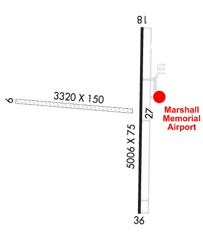
Runway Identifications
Runway Identification: 09/27Length: 3303 ft
Width: 150 ft
Surface: GRASS
Edge lights: Treatment: NONE
| | Runway: 09 | | Runway: 27 |
| Mag heading: | 93° | Mag heading: | 273° |
| Rwy Slope: | .85% Up | Rwy Slope: | -.85% Down |
| Approach: | | Approach: | |
| Pattern: | Right Traffic | Pattern: | Left Traffic |
| Markings: | NONE | Markings: | NONE |
| Marking Condition: | FAIR; RY 09/27 MKD WITH LARGE YELLOW CONES. | Marking Condition: | FAIR |
| Arresting Dev: | | Arresting Dev: | |
| Lat & Long: | N3905.8 W09312.8 | Lat. & Long.: | N3905.7 W09312.1 |
| Elev: | 749.8 ft. MSL | Elev: | 777.9 ft. MSL |
| TCH: | | TCH: | |
| Visual Glide Path: | | Visual Glide Path: | |
| Displaced Threshold: | No | Displaced Threshold: | No |
| Touchdown Zone: | YES | Touchdown Zone: | YES |
| Touchdown Elev.: | 776.4 feet | Touchdown Elev.: | 777.9 feet |
| Visual Glide Slope: | | Visual Glide Slope: | |
| RVR Equipment: | | RVR Equipment: | |
| RVV Equipment: | NO | RVV Equipment: | NO |
| Approach Lights: | | Approach Lights: | |
| REIL: | NO | REIL: | NO |
| Centerline Lights: | NO | Centerline Lights: | NO |
| Touchdown lights: | NO | Touchdown lights: | NO |
| Runway Category: | Runway with a Visual Approach | Runway Category: | Runway with a Visual Approach |
| Declared Distances: | | Declared Distances: | |
Runway Identification: 18/36Length: 5005 ft
Width: 75 ft
Surface: CONCRETE
Edge lights: Medium IntensityTreatment: NONE
| | Runway: 18 | | Runway: 36 |
| Mag heading: | 178° | Mag heading: | 358° |
| Rwy Slope: | .17% Up | Rwy Slope: | -.17% Down |
| Approach: | | Approach: | |
| Pattern: | Left Traffic | Pattern: | Left Traffic |
| Markings: | NONPRECISION INSTRUMENT | Markings: | NONPRECISION INSTRUMENT |
| Marking Condition: | GOOD | Marking Condition: | GOOD |
| Arresting Dev: | | Arresting Dev: | |
| Lat & Long: | N3906.1 W09312.0 | Lat. & Long.: | N3905.3 W09312.0 |
| Elev: | 770.4 ft. MSL | Elev: | 778.9 ft. MSL |
| TCH: | 39 ft. AGL | TCH: | 36 ft. AGL |
| Visual Glide Path: | 3.05 degrees | Visual Glide Path: | 3.04 degrees |
| Displaced Threshold: | 200 feet | Displaced Threshold: | No |
| Touchdown Zone: | YES | Touchdown Zone: | YES |
| Touchdown Elev.: | 778.9 feet | Touchdown Elev.: | 778.9 feet |
| Visual Glide Slope: | 4-Light PAPI on LEFT side of Runway | Visual Glide Slope: | 4-Light PAPI on LEFT side of Runway |
| RVR Equipment: | | RVR Equipment: | |
| RVV Equipment: | NO | RVV Equipment: | NO |
| Approach Lights: | | Approach Lights: | |
| REIL: | NO | REIL: | YES |
| Centerline Lights: | NO | Centerline Lights: | NO |
| Touchdown lights: | NO | Touchdown lights: | NO |
| Runway Category: | Runway with a Non-precision Approach having visibility minimums greater than 3/4 mile | Runway Category: | Runway with a Non-precision Approach having visibility minimums greater than 3/4 mile |
| Declared Distances: | | Declared Distances: | |
| Obstructions: | TREES | Obstructions: | |
| Marked: | NOT Marked/Lighted | Marked: | |
| Clearance slope: | 14:1; RWY 18 APCH SLOPE 22:1 TO DSPLCD THR. | Clearance slope: | 34:1 |
| Obstruction height: | 61 feet AGL | Obstruction height: | |
| Dist. from runway: | 1085 feet | Dist. from runway: | |
| Centerline offset: | 375 right of centerline | Centerline offset: | |
| Comments: | | Comments: | |