Current Weather/Notams (Metars, TAFs, Notams, NWS Forecast, PIREPS, and nearby weather)
Customs Information Send updates to Support@FltPlan.com
Customs Not Available
Database effective 05/16/2024
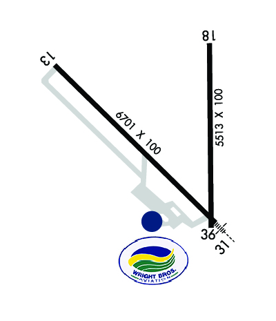
Airport Diagram might not be current. Facility Name: MITCHELL MUNI City Name: MITCHELL County: DAVISON State abbrev: SD State Name: SOUTH DAKOTA Ownership: PUBLICLY OWNED Use: OPEN TO THE PUBLIC Owner's Name: CITY OF MITCHELL Address: 612 N MAIN ST. MITCHELL, SD 57301 Owner's Phone: 605-995-8420 Manager's Name: MIKE SCHERSCHLIGT Address: 621 WEST 5TH MITCHELL, SD 57301 Phone: 605-770-4594 FAA Region: GREAT LAKES FAA Field Office: DMA
Runway Identifications Help
Runway Identification: 13/31 Length: 6701 ftWidth: 100 ftSurface: ASPHALT-GOOD CONDITIONEdge lights: High Intensity Treatment: NONE Runway: 13 Runway: 31 Mag heading: 130° Mag heading: 310° Rwy Slope: .11% Up Rwy Slope: -.11% Down Approach: Approach: ILS Pattern: Left Traffic Pattern: Left Traffic Markings: PRECISION INSTRUMENT Markings: PRECISION INSTRUMENT Marking Condition: GOOD Marking Condition: GOOD Arresting Dev: Arresting Dev: Lat & Long: N4346.9 W09803.1 Lat. & Long.: N4346.1 W09802.0 Elev: 1296.1 ft. MSL Elev: 1303.6 ft. MSL TCH: 45 ft. AGL TCH: 61 ft. AGL Visual Glide Path: 3.00 degrees Visual Glide Path: 3.00 degrees Displaced Threshold: No Displaced Threshold: No Touchdown Zone: YES Touchdown Zone: YES Touchdown Elev.: 1300.6 feet Touchdown Elev.: 1304.4 feet Visual Glide Slope: 4-Light PAPI on LEFT side of Runway Visual Glide Slope: 4-Light PAPI on LEFT side of Runway RVR Equipment: RVR Equipment: RVV Equipment: NO RVV Equipment: NO Approach Lights: Approach Lights: MALSR - 1,400 foot medium intensity approach lighting system with runway alignment indicator lights REIL: YES REIL: NO Centerline Lights: NO Centerline Lights: NO Touchdown lights: NO Touchdown lights: NO Runway Category: Runway with a Non-precision Approach having visibility minimums greater than 3/4 mile Runway Category: Precision Instrument Runway Declared Distances: Declared Distances:
Runway Identification: 18/36 Length: 5513 ftWidth: 100 ftSurface: ASPHALT-FAIR CONDITIONEdge lights: Medium Intensity Treatment: POROUS FRICTION COURSE Runway: 18 Runway: 36 Mag heading: 176° Mag heading: 356° Rwy Slope: .37% Up Rwy Slope: -.37% Down Approach: Approach: Pattern: Left Traffic Pattern: Left Traffic Markings: NONPRECISION INSTRUMENT Markings: NONPRECISION INSTRUMENT Marking Condition: FAIR Marking Condition: FAIR Arresting Dev: Arresting Dev: Lat & Long: N4347.0 W09802.0 Lat. & Long.: N4346.1 W09802.0 Elev: 1282.8 ft. MSL Elev: 1303.0 ft. MSL TCH: 55 ft. AGL TCH: 50 ft. AGL Visual Glide Path: 3.00 degrees Visual Glide Path: 3.00 degrees Displaced Threshold: No Displaced Threshold: No Touchdown Zone: YES Touchdown Zone: YES Touchdown Elev.: 1298.0 feet Touchdown Elev.: 1304.3 feet Visual Glide Slope: 4-Light PAPI on LEFT side of Runway Visual Glide Slope: 4-Light PAPI on LEFT side of Runway RVR Equipment: RVR Equipment: RVV Equipment: NO RVV Equipment: NO Approach Lights: Approach Lights: REIL: YES REIL: NO Centerline Lights: NO Centerline Lights: NO Touchdown lights: NO Touchdown lights: NO Runway Category: Runway with a Non-precision Approach having visibility minimums greater than 3/4 mile Runway Category: Runway with a Non-precision Approach having visibility minimums greater than 3/4 mile Declared Distances: Declared Distances: