Click here for more info on on SMS!

KMGY

DAYTON-WRIGHT BROTHERS
DAYTON
OH
Time Zone: Eastern
Lat: N 3935.3
Long: W 08413.5
Elev: 957
Var: +04
Longest Runway: 5000
Clr Del: 119.4
AWOS: 118.37
CTAF: 122.8

FBO & Flight Services info for KMGY

FBOs: Update your Fuel Prices

FIRST FLIGHT AVPh: 937-885-5580 Fax: 937-885-5586 Freq: 122.8
Service
Jet
100LL
SAF
MoGas
Fuel Avail: PRIST+$0.05/gal. Price includes tax 7A- 8P , SUN-SAT. | After Hours Call Out (937) 313 - 6840
Full5.356.20    Last Update: 04/12/2024 10:27

Self        
 Address: 10600 SPRINGBORO PIKE,   MIAMISBURG, OH 45342
ASOSPh: 937-885-2171
-
Freq: 118.37  
If you are an FBO, call 1-203-262-1700 to update your info or email: FltPlan.Advertising@garmin.com
Advertise your FBO on FltPlan.com

Runway & Approach Info for KMGY
Rwy
Length
Land Dist**
Approach*
  Rwy
Length
Land Dist**
Approach*
02
5000x100  5000'          
 
  
20
  5000x100  4410'          
LOC/DME
 109.50 - 206°  
 * only ILS, LOC, LDA, and SDF approaches to a specific runway are shown
** For any Declared Landing Distance Available, please see A/FD or Approach plates
Runway Weight Capability (lbs.) Help
Runway IDSingle WheelDouble WheelDouble Tandem WheelDual Double Wheel
02/2050,00060,000N/AN/A
These numbers are Advisory and are not limits.   The Airport Manager should have more accurate Weight Limits
Approach Charts
Approaches    
Current Weather/Notams
Customs Information Send updates to Support@FltPlan.com
Customs Not Available
Database effective 04/18/2024
Airport Diagram of KMGY
Airport Diagram might not be current.

Facility Name: DAYTON/WRIGHT BROTHERS
City Name: DAYTON
County: MONTGOMERY
State abbrev: OH
State Name: OHIO
   
Ownership: PUBLICLY OWNED
Use: OPEN TO THE PUBLIC
Owner's Name: CITY OF DAYTON
Address: 3600 TERMINAL DR STE 300
 VANDALIA, OH 45377-1095
Owner's Phone: 937-885-4121
  
Manager's Name: BRANDON ELLIS
Address: 10550 N SPRINGBORO PIKE
 MIAMISBURG, OH 45342-4956
Phone: 937-454-8230; CELL 937-776-2194.
   
FAA Region: GREAT LAKES
FAA Field Office: DET


Sunrise / Sunset times for DAYTON/WRIGHT BROTHERS

DateSunriseSunset
04/19/24 Friday6:5320:20
04/20/24 Saturday6:5120:21
04/21/24 Sunday6:5020:22
04/22/24 Monday6:4920:23
04/23/24 Tuesday6:4720:24
04/24/24 Wednesday6:4620:25
04/25/24 Thursday6:4420:26
04/26/24 Friday6:4320:27
04/27/24 Saturday6:4220:28
04/28/24 Sunday6:4120:29
04/29/24 Monday6:3920:30
04/30/24 Tuesday6:3820:31
05/01/24 Wednesday6:3720:32
05/02/24 Thursday6:3620:33

Airport Facilities

Airport Attendance Schedule7 Days A Week 0700-2000
Airport Status OPERATIONAL (This Status can change at any time - please check NOTAMS)
Airport Lighting ScheduleACTVT MALS RWY 20; PAPI RWY 02 & 20; MIRL RWY 02/20 - CTAF. TWY LGTS OPR CONSLY SS-SR.
Airport Storage AvailableTie Downs, Hanger
Extra Services AvailableAir Freight, Cargo Handling, Charter, Flight Instruction, Aircraft Rental, Aircraft Sales
Wind IndicatorYES - (lighted)
Control TowerNO
CTAF Frequency122.800
Unicom Frequency122.800
Rotating Beacon ColorWG
Segmented CircleNO
Landing FeeNO

Airport Inspection Data

Airport InspectedSTATE - performed by STATE AERONAUTICAL PERSONNEL
Inspection Date09/08/2022

Airport Services

Type of Fuel AvailableGrade 100LL, JET A (freeze point -40C), JET A
Airframe Repair ServiceMAJOR
Power Plant Repair ServiceMAJOR

Geographic Data

LatitudeN3935.3
LongitudeW08413.5 (ESTIMATED)
Arpt Elevation956ft (SURVEYED)
Magnetic Variation04W
10 miles Sof DAYTON
Traffic Pattern Altitude
Sectional ChartCINCINNATI

Aircraft Data

Operations (Reported)YearlyAvg. Daily
General Aviation Transient 1088530
General Aviation Local 2700874
Air Taxi 9373
Commerical 00
Commuter 00
Military 210
Aircraft based on Field
General Aviation Singles 60
General Aviation Multi 10
Jet Aircraft 7
General Aviation Helicopters 5
Military Aircraft 0
Gliders 0
Ultralights 0

FAA Services

FSS on field NO
FSS tie-in DAYTON
FSS Phone 1-800-WX-BRIEF
Who issues Notams MGY
Notam D service at airport YES
ARTCC Name INDIANAPOLIS

Federal Status

Airport Certification
Aircraft Rescue & Firefighting IndexNone
Airport of EntryNo
Custom Landing RightsNo
Joint Civil/MilitaryNo
Military Landing rightsYES

Federal Agreements

NATIONAL PLAN OF INTEGRATED AIRPORT SYSTEMS (NPIAS)
GRANT AGREEMENTS UNDER FAAP/ADAP/AIP
ASSURANCES PURSUANT TO TITLE VI, CIVIL RIGHTS ACT OF 1964

Remarks

THIS AIRPORT HAS BEEN SURVEYED BY THE NATIONAL GEODETIC SURVEY.
DEER, BIRDS, & OTR WILDLIFE ON & INVOF ARPT.
SFC CONDS UNMON 1530-0700 WKDAYS & ALL DAY WKENDS/HOLS.
FULL PWR MAINT RUNUPS PROHIBITED IN THE HLDG APN AT THE NW CORNER OF TWY A 0800-1700 WKDAYS.
Airport Communications & Frequencies:
Clearance Delivery Frequencies:
119.4
CTAF Frequency:
122.800
Unicom Frequency:
122.800
COLUMBUS Primary Approach Frequencies:  
118.85
269.275
COLUMBUS Primary Departure Frequencies:  
118.85
269.275
Runway Identifications
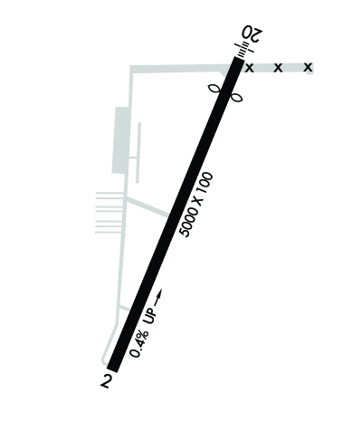
Runway Identification: 02/20
Length: 5000 ft
Width: 100 ft
Surface: ASPHALT-GOOD CONDITION
Edge lights: Medium Intensity

Treatment: GROOVED

 Runway: 02   Runway: 20
Mag heading: 26°Mag heading: 206°
Rwy Slope: .41% UpRwy Slope: -.41% Down
Approach: Approach: LOC/DME
Pattern: Left TrafficPattern: Left Traffic
Markings: NONPRECISION INSTRUMENTMarkings: NONPRECISION INSTRUMENT
Marking Condition: FAIRMarking Condition: FAIR
Arresting Dev: Arresting Dev:
Lat & Long: N3935.0  W08413.7Lat. & Long.: N3935.7  W08413.3
Elev: 936.2 ft. MSLElev: 956.6 ft. MSL
TCH: 49 ft. AGLTCH: 39 ft. AGL
Visual Glide Path: 3.00 degreesVisual Glide Path: 3.00 degrees
Displaced Threshold: NoDisplaced Threshold: 590 feet
Touchdown Zone: YESTouchdown Zone: YES
Touchdown Elev.: 948.7 feetTouchdown Elev.: 955.1 feet
Visual Glide Slope: 2-Light PAPI on LEFT side of RunwayVisual Glide Slope: 4-Light PAPI on LEFT side of Runway; PAPI UNUSBL BYD 7 DEGS RIGHT OF CNTRLN.
RVR Equipment: RVR Equipment:
RVV Equipment: NORVV Equipment: NO
Approach Lights: Approach Lights: MALS - 1,400 foot medium intensity approach lighting system
REIL: NOREIL: NO
Centerline Lights: NOCenterline Lights: NO
Touchdown lights: NOTouchdown lights: NO
Runway Category: Runway with a Non-precision Approach having visibility minimums greater than 3/4 mileRunway Category: Runway with a Non-precision Approach having visibility minimums greater than 3/4 mile
Declared Distances: TORA:5000' TODA:5000' ASDA:4700' LDA:4700'Declared Distances: TORA:5000' TODA:5000' ASDA:5000' LDA:4410'
Obstructions: Obstructions: ROAD
Marked: Marked: NOT Marked/Lighted
Clearance slope: 34:1Clearance slope: 13:1; APCH SLP 34:1 TO DTHR.
Obstruction height: Obstruction height: 25 feet AGL
Dist. from runway: Dist. from runway: 540 feet
Centerline offset: Centerline offset: 300 feet right of centerline
Comments: Comments:
C:31/P: