
| ||||||||||||||||||||||||||||||||||||||||||||
| ||||||||||||||||||||||||||||||||||||||||||||
| ||||||||||||||||||||||||||||||||||||||||||||
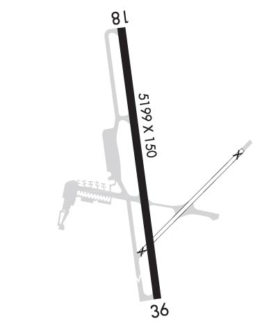
| Rwy | Rwy | |||||||
| 5199x150 | 5199' | 108.50 - 181° | 5199x150 | 5199' | ||||
| Runway ID | Single Wheel | Double Wheel | Double Tandem Wheel | Dual Double Wheel |
| 18/36 | 65,000 | 90,000 | 175,000 | N/A |
| These numbers are Advisory and are not limits. The Airport Manager should have more accurate Weight Limits | ||||
 Airport Diagram might not be current. | |
| Facility Name: | MORGANTOWN MUNI/WALTER L BILL HART FLD |
| City Name: | MORGANTOWN |
| County: | MONONGALIA |
| State abbrev: | WV |
| State Name: | WEST VIRGINIA |
| Ownership: | PUBLICLY OWNED |
| Use: | OPEN TO THE PUBLIC |
| Owner's Name: | CITY OF MORGANTOWN |
| Address: | 389 SPRUCE ST |
| MORGANTOWN, WV 26505 | |
| Owner's Phone: | 304-284-7405 |
| Manager's Name: | JONATHON VRABEL |
| Address: | 100 HART FIELD RD |
| MORGANTOWN, WV 26505 | |
| Phone: | 304-291-7461 |
| FAA Region: | EASTERN |
| FAA Field Office: | BKW |
| Date | Sunrise | Sunset |
|---|---|---|
| 04/17/24 Wednesday | 6:38 | 20:00 |
| 04/18/24 Thursday | 6:37 | 20:01 |
| 04/19/24 Friday | 6:35 | 20:02 |
| 04/20/24 Saturday | 6:34 | 20:03 |
| 04/21/24 Sunday | 6:33 | 20:04 |
| 04/22/24 Monday | 6:31 | 20:05 |
| 04/23/24 Tuesday | 6:30 | 20:06 |
| 04/24/24 Wednesday | 6:28 | 20:07 |
| 04/25/24 Thursday | 6:27 | 20:08 |
| 04/26/24 Friday | 6:26 | 20:09 |
| 04/27/24 Saturday | 6:25 | 20:10 |
| 04/28/24 Sunday | 6:23 | 20:11 |
| 04/29/24 Monday | 6:22 | 20:12 |
| 04/30/24 Tuesday | 6:21 | 20:13 |
| Airport Attendance Schedule | MON-FRI 0500-0000, SAT-SUN 0500-2300 |
| Airport Status | OPERATIONAL (This Status can change at any time - please check NOTAMS) |
| Airport Lighting Schedule | WHEN ATCT CLSD ACTVT MALSR RWY 18; REIL RWY 36; VASI RWY 36; HIRL RWY 18/36; TWY LGTS - CTAF. |
| Airport Storage Available | Tie Downs, Hanger |
| Extra Services Available | Air Ambulance, Charter, Flight Instruction |
| Wind Indicator | YES - (lighted) |
| Control Tower | YES |
| CTAF Frequency | 125.100 |
| Unicom Frequency | 122.950 |
| Rotating Beacon Color | WG |
| Segmented Circle | NO |
| Landing Fee | YES; LNDG FEE FOR ACFT 6500 LBS & OVER. |
| Airport Inspected | FEDERAL - performed by FAA AIRPORTS FIELD PERSONNEL |
| Inspection Date | 05/31/2023 |
| Type of Fuel Available | Grade 100LL, JET A (freeze point -40C) |
| Airframe Repair Service | MINOR |
| Power Plant Repair Service | MINOR |
| Latitude | N3938.6 |
| Longitude | W07955.1 (ESTIMATED) |
| Arpt Elevation | 1243ft (SURVEYED) |
| Magnetic Variation | 09W |
| 3 miles E | of MORGANTOWN |
| Traffic Pattern Altitude | |
| Sectional Chart | CINCINNATI |
| Operations (Reported) | Yearly | Avg. Daily |
|---|---|---|
| General Aviation Transient | 14782 | 40 |
| General Aviation Local | 18711 | 51 |
| Air Taxi | 24524 | 67 |
| Commerical | 0 | 0 |
| Commuter | 0 | 0 |
| Military | 1624 | 4 |
| Aircraft based on Field | |
|---|---|
| General Aviation Singles | 22 |
| General Aviation Multi | 1 |
| Jet Aircraft | 0 |
| General Aviation Helicopters | 0 |
| Military Aircraft | 0 |
| Gliders | 0 |
| Ultralights | 0 |
| FSS on field | NO |
| FSS tie-in | ELKINS |
| FSS Phone | 1-800-WX-BRIEF |
| Who issues Notams | MGW |
| Notam D service at airport | YES |
| ARTCC Name | CLEVELAND |
| Airport Certification | AIRPORT RECEIVING SCHEDULED AIR CARRIER SERVICE FROM CARRIERS CERTIFICATED BY THE CIVIL AERONAUTICS BOARD; PPR 24 HRS FOR UNSCHEDULED ACR OPNS, CALL AMGR 304-291-7461. |
| Aircraft Rescue & Firefighting Index | AIRPORT HAS A CERTIFICATE UNDER CFR PART 139 |
| Airport of Entry | No |
| Custom Landing Rights | No |
| Joint Civil/Military | No |
| Military Landing rights | YES |
| NATIONAL PLAN OF INTEGRATED AIRPORT SYSTEMS (NPIAS) |
| GRANT AGREEMENTS UNDER FAAP/ADAP/AIP |
| COMPLIANCE WITH ACCESSIBILITY TO THE HANDICAPPED |
| ASSURANCES PURSUANT TO TITLE VI, CIVIL RIGHTS ACT OF 1964 |
| DEER & BIRDS ON & INVOF ARPT. |
| FBO HRS MON-FRI 0500-0000, SAT-SUN 0500-2300. 24-HR PHONE NR 304-296-2359. |
| BE ALERT: POSSIBILITY OF TURBULENCE INVOF POWER PLANT STACKS 3.6 MILES N OF AFLD DURG COLD WEATHER. |
| FOR CD CTC CLARKSBURG APCH AT 304-842-2011, WHEN APCH CLSD CTC CLEVELAND ARTCC AT 440-774-0226. |
Airport Communications & Frequencies:
| |||||||||||||||||||||||
| Runway: 18 | Runway: 36 | ||
| Mag heading: | 181° | Mag heading: | 1° |
| Rwy Slope: | .14% Up | Rwy Slope: | -.14% Down |
| Approach: | ILS | Approach: | |
| Pattern: | Left Traffic | Pattern: | Left Traffic |
| Markings: | PRECISION INSTRUMENT | Markings: | PRECISION INSTRUMENT |
| Marking Condition: | GOOD | Marking Condition: | GOOD |
| Arresting Dev: | Arresting Dev: | ||
| Lat & Long: | N3939.0 W07955.1 | Lat. & Long.: | N3938.2 W07955.0 |
| Elev: | 1236.1 ft. MSL | Elev: | 1243.6 ft. MSL |
| TCH: | 59 ft. AGL | TCH: | 52 ft. AGL |
| Visual Glide Path: | 3.00 degrees | Visual Glide Path: | 3.00 degrees |
| Displaced Threshold: | No | Displaced Threshold: | No |
| Touchdown Zone: | YES | Touchdown Zone: | YES |
| Touchdown Elev.: | 1239.5 feet | Touchdown Elev.: | 1243.7 feet |
| Visual Glide Slope: | 4-Light PAPI on LEFT side of Runway | Visual Glide Slope: | 4-BOX VASI ON LEFT SIDE OF RUNWAY |
| RVR Equipment: | RVR Equipment: | ||
| RVV Equipment: | NO | RVV Equipment: | NO |
| Approach Lights: | MALSR - 1,400 foot medium intensity approach lighting system with runway alignment indicator lights | Approach Lights: | |
| REIL: | NO | REIL: | YES |
| Centerline Lights: | NO | Centerline Lights: | NO |
| Touchdown lights: | NO | Touchdown lights: | NO |
| Runway Category: | Precision Instrument Runway | Runway Category: | Runway with a Non-precision Approach having visibility minimums greater than 3/4 mile |
| Declared Distances: | TORA:5199' TODA:5199' ASDA:5199' LDA:5199' | Declared Distances: | TORA:5199' TODA:5199' ASDA:5199' LDA:5199' |
