Current Weather/Notams (Metars, TAFs, Notams, NWS Forecast, PIREPS, and nearby weather)
Customs Information Send updates to Support@FltPlan.com
Customs Not Available
Database effective 04/18/2024
Airport Diagram might not be current.
|
| Facility Name: | MOULTRIE MUNI |
| City Name: | MOULTRIE |
| County: | COLQUITT |
| State abbrev: | GA |
| State Name: | GEORGIA |
| | |
| Ownership: | PUBLICLY OWNED |
| Use: | OPEN TO THE PUBLIC |
| Owner's Name: | MOULTRIE COLQUITT COUNTY APT AUTH |
| Address: | 300 CAMELLIA DRIVE |
| | MOULTRIE, GA 31768 |
| Owner's Phone: | (229) 873-4278 |
| | |
| Manager's Name: | MIKE BOYD; CHAIRMAN ARPT AUTHORITY. |
| Address: | 1 TERRACE COURT |
| | MOULTRIE, GA 31788 |
| Phone: | (229) 873-4278 |
| | |
| FAA Region: | SOUTHERN |
| FAA Field Office: | ATL |
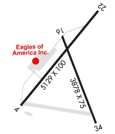
Runway Identifications
Runway Identification: 04/22Length: 6000 ft
Width: 100 ft
Surface: ASPHALT-GOOD CONDITION
Edge lights: Medium IntensityTreatment: GROOVED
| | Runway: 04 | | Runway: 22 |
| Mag heading: | 44° | Mag heading: | 224° |
| Rwy Slope: | .47% Up | Rwy Slope: | -.47% Down |
| Approach: | | Approach: | |
| Pattern: | Left Traffic | Pattern: | Left Traffic |
| Markings: | NONPRECISION INSTRUMENT | Markings: | NONPRECISION INSTRUMENT |
| Marking Condition: | GOOD | Marking Condition: | GOOD |
| Arresting Dev: | | Arresting Dev: | |
| Lat & Long: | N3104.8 W08348.6 | Lat. & Long.: | N3105.6 W08347.8 |
| Elev: | 269.1 ft. MSL | Elev: | 297.1 ft. MSL |
| TCH: | 45 ft. AGL | TCH: | 25 ft. AGL |
| Visual Glide Path: | 3.00 degrees | Visual Glide Path: | 3.00 degrees |
| Displaced Threshold: | No | Displaced Threshold: | 372 feet |
| Touchdown Zone: | YES | Touchdown Zone: | YES |
| Touchdown Elev.: | 288.9 feet | Touchdown Elev.: | 296.0 feet |
| Visual Glide Slope: | 2-Light PAPI on LEFT side of Runway | Visual Glide Slope: | 2-Light PAPI on LEFT side of Runway |
| RVR Equipment: | | RVR Equipment: | |
| RVV Equipment: | NO | RVV Equipment: | NO |
| Approach Lights: | | Approach Lights: | |
| REIL: | NO | REIL: | NO |
| Centerline Lights: | NO | Centerline Lights: | NO |
| Touchdown lights: | NO | Touchdown lights: | NO |
| Runway Category: | Runway with a Non-precision Approach having visibility minimums greater than 3/4 mile | Runway Category: | Runway with a Non-precision Approach having visibility minimums greater than 3/4 mile |
| Declared Distances: | TORA:6000' TODA:6000' ASDA:6000' LDA:6000' | Declared Distances: | TORA:6000' TODA:6000' ASDA:6000' LDA:5628' |
| Obstructions: | TREES | Obstructions: | TREES |
| Marked: | NOT Marked/Lighted | Marked: | NOT Marked/Lighted |
| Clearance slope: | 21:1 | Clearance slope: | 20:1 |
| Obstruction height: | 25 feet AGL | Obstruction height: | 89 feet AGL |
| Dist. from runway: | 725 feet | Dist. from runway: | 1980 feet |
| Centerline offset: | 301 right of centerline | Centerline offset: | 414 feet right of centerline |
| Comments: | | Comments: | |
Runway Identification: 16/34Length: 3878 ft
Width: 75 ft
Surface: ASPHALT-GOOD CONDITION
Edge lights: Treatment: NONE
| | Runway: 16 | | Runway: 34 |
| Mag heading: | 164° | Mag heading: | 344° |
| Rwy Slope: | -.47% Down | Rwy Slope: | .47% Up |
| Approach: | | Approach: | |
| Pattern: | Left Traffic | Pattern: | Left Traffic |
| Markings: | BASIC | Markings: | BASIC |
| Marking Condition: | GOOD | Marking Condition: | GOOD |
| Arresting Dev: | | Arresting Dev: | |
| Lat & Long: | N3105.3 W08348.2 | Lat. & Long.: | N3104.7 W08348.0 |
| Elev: | 288.2 ft. MSL | Elev: | 270.1 ft. MSL |
| TCH: | | TCH: | |
| Visual Glide Path: | | Visual Glide Path: | |
| Displaced Threshold: | No | Displaced Threshold: | No |
| Touchdown Zone: | YES | Touchdown Zone: | YES |
| Touchdown Elev.: | 289.0 feet | Touchdown Elev.: | 288.2 feet |
| Visual Glide Slope: | | Visual Glide Slope: | |
| RVR Equipment: | | RVR Equipment: | |
| RVV Equipment: | NO | RVV Equipment: | NO |
| Approach Lights: | | Approach Lights: | |
| REIL: | NO | REIL: | NO |
| Centerline Lights: | NO | Centerline Lights: | NO |
| Touchdown lights: | NO | Touchdown lights: | NO |
| Runway Category: | Runway with a Visual Approach | Runway Category: | Runway with a Visual Approach |
| Declared Distances: | | Declared Distances: | |
| Obstructions: | TREES | Obstructions: | TREES |
| Marked: | NOT Marked/Lighted | Marked: | NOT Marked/Lighted |
| Clearance slope: | 11:1 | Clearance slope: | 18:1 |
| Obstruction height: | 72 feet AGL | Obstruction height: | 76 feet AGL |
| Dist. from runway: | 992 feet | Dist. from runway: | 1568 feet |
| Centerline offset: | 203 left of centerline | Centerline offset: | 261 feet right of centerline |
| Comments: | | Comments: | |