Click here for more info on on SMS!

KMGN

HARBOR SPRINGS
HARBOR SPRINGS
MI
Time Zone: Eastern
Lat: N 4525.5
Long: W 08454.8
Elev: 686
Var: +05
Longest Runway: 4149
AWOS: 119.92
CTAF: 122.8

FBO & Flight Services info for KMGN

FBOs: Update your Fuel Prices

HARBOR SPRINGSPh: 231-347-2812 Fax: 231-347-2095 Freq: 122.8
Service
Jet
100LL
SAF
MoGas
Fuel Avail: PRIST PREMIXED. 8AM- SUNSET
Full6.957.30    Last Update: 04/04/2024 08:31

Self        
 Address: 8350 M-119 HARBOR   SPRINGS, MI 49740
AWOSPh: 231-347-5231
-
Freq: 119.92  
If you are an FBO, call 1-203-262-1700 to update your info or email: FltPlan.Advertising@garmin.com
Advertise your FBO on FltPlan.com

Runway & Approach Info for KMGN
Rwy
Length
Land Dist**
Approach*
  Rwy
Length
Land Dist**
Approach*
10
4149x75  3712'          
 
  
28
  4149x75  3705'          
 
 * only ILS, LOC, LDA, and SDF approaches to a specific runway are shown
** For any Declared Landing Distance Available, please see A/FD or Approach plates
Runway Weight Capability (lbs.) Help
Runway IDSingle WheelDouble WheelDouble Tandem WheelDual Double Wheel
10/2822,00030,000N/AN/A
These numbers are Advisory and are not limits.   The Airport Manager should have more accurate Weight Limits
Approach Charts
Approaches    
Current Weather/Notams
Customs Information Send updates to Support@FltPlan.com
Customs Not Available
Database effective 04/18/2024
Airport Diagram of KMGN
Airport Diagram might not be current.

Facility Name: HARBOR SPRINGS
City Name: HARBOR SPRINGS
County: EMMET
State abbrev: MI
State Name: MICHIGAN
   
Ownership: PUBLICLY OWNED
Use: OPEN TO THE PUBLIC
Owner's Name: HARBOR/PETOSKEY AREA AIRPORT AUTH
Address: C/O WILLIAM P DOHM, PO BOX 274
 CONWAY, MI 49722-0274
Owner's Phone: 231-242-4906
  
Manager's Name: MARK ZABAWA
Address: 8350 M-119
 HARBOR SPRINGS, MI 49740-9077
Phone: 231-206-9333; CELL.
   
FAA Region: GREAT LAKES
FAA Field Office: DET


Sunrise / Sunset times for HARBOR SPRINGS

DateSunriseSunset
04/19/24 Friday6:4620:32
04/20/24 Saturday6:4420:33
04/21/24 Sunday6:4320:35
04/22/24 Monday6:4120:36
04/23/24 Tuesday6:3920:37
04/24/24 Wednesday6:3820:38
04/25/24 Thursday6:3620:40
04/26/24 Friday6:3420:41
04/27/24 Saturday6:3320:42
04/28/24 Sunday6:3120:43
04/29/24 Monday6:3020:45
04/30/24 Tuesday6:2820:46
05/01/24 Wednesday6:2720:47
05/02/24 Thursday6:2520:48

Airport Facilities

Airport Attendance Schedule7 Days A Week 0800-DUSK
Airport Status OPERATIONAL (This Status can change at any time - please check NOTAMS)
Airport Lighting ScheduleACTVT MIRL RWY 10/28 - CTAF. PAPI RWY 10 & 28 OPR CONSLY.
Airport Storage AvailableTie Downs
Extra Services AvailableNONE
Wind IndicatorYES - (lighted)
Control TowerNO
CTAF Frequency122.800
Unicom Frequency122.800
Rotating Beacon ColorWG
Segmented CircleNO
Landing FeeYES; LDG FEE WAIVED WITH MNM FUEL PURCHASE.

Airport Inspection Data

Airport InspectedSTATE - performed by STATE AERONAUTICAL PERSONNEL
Inspection Date03/30/2023

Airport Services

Type of Fuel AvailableGrade 100LL, JET A
Airframe Repair ServiceNone
Power Plant Repair ServiceNone

Geographic Data

LatitudeN4525.5
LongitudeW08454.8 (ESTIMATED)
Arpt Elevation685ft (SURVEYED)
Magnetic Variation05W
3 miles Eof HARBOR SPRINGS
Traffic Pattern Altitude
Sectional ChartLAKE HURON

Aircraft Data

Operations (Reported)YearlyAvg. Daily
General Aviation Transient 1200033
General Aviation Local 450012
Air Taxi 00
Commerical 00
Commuter 00
Military 00
Aircraft based on Field
General Aviation Singles 13
General Aviation Multi 1
Jet Aircraft 1
General Aviation Helicopters 0
Military Aircraft 0
Gliders 0
Ultralights 0

FAA Services

FSS on field NO
FSS tie-in LANSING
FSS Phone 1-800-WX-BRIEF
Who issues Notams MGN
Notam D service at airport YES
ARTCC Name MINNEAPOLIS

Federal Status

Airport Certification
Aircraft Rescue & Firefighting IndexNone
Airport of EntryNo
Custom Landing RightsNo
Joint Civil/MilitaryNo
Military Landing rightsNo

Federal Agreements

NATIONAL PLAN OF INTEGRATED AIRPORT SYSTEMS (NPIAS)

Remarks

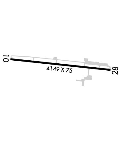
RWY 10 APCH AREA HAS TWO 70 FT LGTD OBSTN POLES, 170 FT LEFT OF CNTRLN; +75 FT TREES ON NORTH SIDE.
FOR CD CTC MINNEAPOLIS ARTCC AT 651-463-5588.
RWY 28 APCH AREA HAS LGTD OBSTN POLES, 165 FT LEFT & 220 FT RIGHT OF CNTRLN; +80 FT TREES ADJ.
BIRDS & DEER ON & INVOF ARPT.
NOISE ABATEMENT PROCS: NO TURBOJET/TURBOFAN ACFT DEPS 2300-0700; NO LOW FLT OVR SRNDG COMMUNITY; ALL ACFT DEPG TO THE WEST TURN SOUTH OVR THE WATER AS SOON AS PRACTICAL.
Airport Communications & Frequencies:
CTAF Frequency:
122.800
Unicom Frequency:
122.800
Remarks
  • APCH/DEP SVC PRVDD BY MINNEAPOLIS ARTCC ON FREQS 134.6/354.05 (PELLSTON RCAG).
  • Runway Identifications
    Runway Identification: 10/28
    Length: 4149 ft
    Width: 75 ft
    Surface: ASPHALT-FAIR CONDITION
    Edge lights: Medium Intensity

    Treatment: NONE

     Runway: 10   Runway: 28
    Mag heading: 101°Mag heading: 281°
    Rwy Slope: .20% UpRwy Slope: -.20% Down
    Approach: Approach:
    Pattern: Left TrafficPattern: Left Traffic
    Markings: NONPRECISION INSTRUMENTMarkings: NONPRECISION INSTRUMENT
    Marking Condition: FAIRMarking Condition: FAIR
    Arresting Dev: Arresting Dev:
    Lat & Long: N4525.6  W08455.3Lat. & Long.: N4525.5  W08454.3
    Elev: 677.3 ft. MSLElev: 685.6 ft. MSL
    TCH: 28 ft. AGLTCH: 35 ft. AGL
    Visual Glide Path: 3.50 degreesVisual Glide Path: 4.00 degrees
    Displaced Threshold: 437 feetDisplaced Threshold: 444 feet
    Touchdown Zone: YESTouchdown Zone: YES
    Touchdown Elev.: 685.1 feetTouchdown Elev.: 685.7 feet
    Visual Glide Slope: 4-Light PAPI on RIGHT side of RunwayVisual Glide Slope: 4-Light PAPI on LEFT side of Runway; PAPI UNUSBL BYD 2 DEGS LEFT OF CNTRLN.
    RVR Equipment: RVR Equipment:
    RVV Equipment: NORVV Equipment: NO
    Approach Lights: Approach Lights:
    REIL: NOREIL: NO
    Centerline Lights: NOCenterline Lights: NO
    Touchdown lights: NOTouchdown lights: NO
    Runway Category: Runway with a Non-precision ApproachRunway Category: Runway with a Non-precision Approach
    Declared Distances: Declared Distances:
    Obstructions: TREEObstructions: POLE
    Marked: LIGHTEDMarked: LIGHTED
    Clearance slope: APCH RATIO 1:1 TO DTHR OVR 80 FT TREES, 80 FT DIST, 261 FT L.Clearance slope: APCH RATIO 0:1 TO DTHR OVR 70 FT POLE, 0 FT DIST, 250 FT L.
    Obstruction height: 35 feet AGLObstruction height: 60 feet AGL
    Dist. from runway: 200 feetDist. from runway: 236 feet
    Centerline offset: 112 right of centerlineCenterline offset: 165 feet left of centerline
    Comments: 4 FT FENCE, 0 FT DIST, 48 FT R; 15 FT ROAD, 0 FT DIST, 75 FT R; 70 FT LGTD POLE, 180 FT DIST, 240 FT R.Comments: 4 FT FENCE, 199 FT DIST; 70 FT TREES, 0 FT DIST, 168 FT L.
    C:17/P: