Current Weather/Notams (Metars, TAFs, Notams, NWS Forecast, PIREPS, and nearby weather)
Customs Information Send updates to Support@FltPlan.com
Customs Not Available
Database effective 05/16/2024
Airport Diagram might not be current.
|
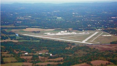
| Facility Name: | ORANGE COUNTY |
| City Name: | MONTGOMERY |
| County: | ORANGE |
| State abbrev: | NY |
| State Name: | NEW YORK |
| | |
| Ownership: | PUBLICLY OWNED |
| Use: | OPEN TO THE PUBLIC |
| Owner's Name: | ORANGE COUNTY |
| Address: | 255 MAIN STREET |
| | GOSHEN, NY 10924 |
| Owner's Phone: | 845-291-4000 |
| | |
| Manager's Name: | EDWARD MAGRYTA |
| Address: | 500 DUNN RD. |
| | MONTGOMERY, NY 12549-2402 |
| Phone: | 845-457-4925 |
| | |
| FAA Region: | EASTERN |
| FAA Field Office: | NYC |
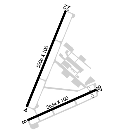
Runway Identifications
Runway Identification: 04/22Length: 5006 ft
Width: 100 ft
Surface: ASPHALT
Edge lights: High IntensityTreatment: GROOVED
| | Runway: 04 | | Runway: 22 |
| Mag heading: | 36° | Mag heading: | 216° |
| Rwy Slope: | .30% Up | Rwy Slope: | -.30% Down |
| Approach: | ILS | Approach: | |
| Pattern: | Left Traffic | Pattern: | Right Traffic |
| Markings: | PRECISION INSTRUMENT | Markings: | PRECISION INSTRUMENT |
| Marking Condition: | GOOD | Marking Condition: | GOOD |
| Arresting Dev: | | Arresting Dev: | |
| Lat & Long: | N4130.5 W07416.1 | Lat. & Long.: | N4131.2 W07415.7 |
| Elev: | 355.0 ft. MSL | Elev: | 369.9 ft. MSL |
| TCH: | 52 ft. AGL | TCH: | 45 ft. AGL |
| Visual Glide Path: | 3.00 degrees | Visual Glide Path: | 3.00 degrees |
| Displaced Threshold: | No | Displaced Threshold: | No |
| Touchdown Zone: | YES | Touchdown Zone: | YES |
| Touchdown Elev.: | 355.5 feet | Touchdown Elev.: | 369.9 feet |
| Visual Glide Slope: | 4-Light PAPI on LEFT side of Runway | Visual Glide Slope: | 2-Light PAPI on LEFT side of Runway |
| RVR Equipment: | | RVR Equipment: | |
| RVV Equipment: | NO | RVV Equipment: | NO |
| Approach Lights: | | Approach Lights: | |
| REIL: | YES | REIL: | YES |
| Centerline Lights: | NO | Centerline Lights: | NO |
| Touchdown lights: | NO | Touchdown lights: | NO |
| Runway Category: | Precision Instrument Runway | Runway Category: | Runway with a Non-precision Approach having visibility minimums greater than 3/4 mile |
| Declared Distances: | | Declared Distances: | |
| Obstructions: | TREES | Obstructions: | TREES |
| Marked: | NOT Marked/Lighted | Marked: | NOT Marked/Lighted |
| Clearance slope: | 6:1 | Clearance slope: | 16:1 |
| Obstruction height: | 54 feet AGL | Obstruction height: | 65 feet AGL |
| Dist. from runway: | 555 feet | Dist. from runway: | 1272 feet |
| Centerline offset: | 489 left of centerline | Centerline offset: | 523 feet right of centerline |
| Comments: | | Comments: | |
Runway Identification: 08/26Length: 3664 ft
Width: 100 ft
Surface: ASPHALT-GOOD CONDITION
Edge lights: Medium IntensityTreatment: NONE
| | Runway: 08 | | Runway: 26 |
| Mag heading: | 80° | Mag heading: | 260° |
| Rwy Slope: | .33% Up | Rwy Slope: | -.33% Down |
| Approach: | | Approach: | |
| Pattern: | Left Traffic | Pattern: | Right Traffic |
| Markings: | NONPRECISION INSTRUMENT | Markings: | PRECISION INSTRUMENT |
| Marking Condition: | GOOD | Marking Condition: | GOOD |
| Arresting Dev: | | Arresting Dev: | |
| Lat & Long: | N4130.4 W07416.1 | Lat. & Long.: | N4130.6 W07415.3 |
| Elev: | 352.0 ft. MSL | Elev: | 364.1 ft. MSL |
| TCH: | 49 ft. AGL | TCH: | 43 ft. AGL |
| Visual Glide Path: | 3.50 degrees | Visual Glide Path: | 3.50 degrees |
| Displaced Threshold: | No | Displaced Threshold: | 315 feet |
| Touchdown Zone: | YES | Touchdown Zone: | YES |
| Touchdown Elev.: | 358.9 feet | Touchdown Elev.: | 360.8 feet |
| Visual Glide Slope: | 2-Light PAPI on LEFT side of Runway | Visual Glide Slope: | 2-Light PAPI on LEFT side of Runway |
| RVR Equipment: | | RVR Equipment: | |
| RVV Equipment: | NO | RVV Equipment: | NO |
| Approach Lights: | | Approach Lights: | |
| REIL: | NO | REIL: | NO |
| Centerline Lights: | NO | Centerline Lights: | NO |
| Touchdown lights: | NO | Touchdown lights: | NO |
| Runway Category: | Runway with a Non-precision Approach | Runway Category: | Runway with a Non-precision Approach |
| Declared Distances: | | Declared Distances: | |
| Obstructions: | TREES | Obstructions: | FENCE |
| Marked: | NOT Marked/Lighted | Marked: | NOT Marked/Lighted |
| Clearance slope: | 23:1 | Clearance slope: | RWY 26 APCH SLOPE 11:1 DUE TO 56 FT TREE 644 FT FM DTHR. |
| Obstruction height: | 69 feet AGL | Obstruction height: | 15 feet AGL |
| Dist. from runway: | 1788 feet | Dist. from runway: | 200 feet |
| Centerline offset: | 28 right of centerline | Centerline offset: | 250 feet left of centerline |
| Comments: | | Comments: | |