Click here for more info on on SMS!

KMGC

MICHIGAN CITY MUNI
MICHIGAN CITY
IN
Time Zone: Central
Lat: N 4142.2
Long: W 08649.3
Elev: 655
Var: +03
Longest Runway: 4099
Clr Del: 118.625
AWOS: 128.45
CTAF: 122.7

FBO & Flight Services info for KMGC

FBOs: Update your Fuel Prices

  click here  
Airport Services & Facilities include: Phillips 66 Jet A w/Prist &100LL, 24-hour Avgas, Clean terminal building, Computerized weather, Fire Department on field, Courtesy car available, Shuttle to Blue Chip Casino, Short drive to Outlet Mall, Space available for lease, Car rental drop-off available.
Ph: 219-872-0121 Fax: 219-872-0121 Freq: 122.7WebsiteE-Mail
                                  
Service
Jet
100LL
SAF
MoGas
Fuel Avail: SWIFT FUEL UL-94
Full4.245.19    Last Update: 04/05/2024 13:31

Self4.244.99  6.70
Misc. Info: Self Service Avgas, Jet A and UL-94 Available 24/7Address: 1300 N HIGHWAY 212   MICHIGAN CITY, IN 46360

AWOSPh: 219-878-1106
-
Freq: 128.45  
If you are an FBO, call 1-203-262-1700 to update your info or email: FltPlan.Advertising@garmin.com
Advertise your FBO on FltPlan.com

Runway & Approach Info for KMGC
Rwy
Length
Land Dist**
Approach*
  Rwy
Length
Land Dist**
Approach*
02
4099x75  3757'          
 
  
20
  4099x75  3916'          
 
 * only ILS, LOC, LDA, and SDF approaches to a specific runway are shown
** For any Declared Landing Distance Available, please see A/FD or Approach plates
Runway Weight Capability (lbs.) Help
Runway IDSingle WheelDouble WheelDouble Tandem WheelDual Double Wheel
02/20N/AN/AN/AN/A
These numbers are Advisory and are not limits.   The Airport Manager should have more accurate Weight Limits
Approach Charts
Approaches    
Current Weather/Notams
Customs Information Send updates to Support@FltPlan.com
Customs Not Available
Database effective 04/18/2024
Airport Diagram of KMGC
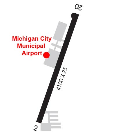
Airport Diagram might not be current.

Facility Name: MICHIGAN CITY MUNI-PHILLIPS FLD
City Name: MICHIGAN CITY
County: LA PORTE
State abbrev: IN
State Name: INDIANA
   
Ownership: PUBLICLY OWNED
Use: OPEN TO THE PUBLIC
Owner's Name: MICHIGAN CITY BOAC; GREG POULIN
Address: 1300 N HWY 212
 MICHIGAN CITY, IN 46360
Owner's Phone: 219-872-0121
  
Manager's Name: JESSICA WARD
Address: 1300 N HIGHWAY 212
 MICHIGAN CITY, IN 46360
Phone: 219-872-0121; EMERG - 219-898-1277
   
FAA Region: GREAT LAKES
FAA Field Office: CHI


Sunrise / Sunset times for MICHIGAN CITY MUNI-PHILLIPS FLD

DateSunriseSunset
04/18/24 Thursday6:0119:32
04/19/24 Friday6:0019:33
04/20/24 Saturday5:5819:34
04/21/24 Sunday5:5719:35
04/22/24 Monday5:5519:37
04/23/24 Tuesday5:5419:38
04/24/24 Wednesday5:5219:39
04/25/24 Thursday5:5119:40
04/26/24 Friday5:5019:41
04/27/24 Saturday5:4819:42
04/28/24 Sunday5:4719:43
04/29/24 Monday5:4619:44
04/30/24 Tuesday5:4419:45
05/01/24 Wednesday5:4319:46

Airport Facilities

Airport Attendance Schedule7 Days A Week 0800-1700
Airport Status OPERATIONAL (This Status can change at any time - please check NOTAMS)
Airport Lighting ScheduleACTVT REIL RWY 20; MIRL RWY 02/20 - CTAF.
Airport Storage AvailableTie Downs, Hanger
Extra Services AvailableParachute Jumping
Wind IndicatorYES - (lighted)
Control TowerNO
CTAF Frequency122.700
Unicom Frequency122.700
Rotating Beacon ColorWG
Segmented CircleYES
Landing FeeNO

Airport Inspection Data

Airport InspectedSTATE - performed by STATE AERONAUTICAL PERSONNEL
Inspection Date06/15/2021

Airport Services

Type of Fuel AvailableGrade 100LL, JET A (freeze point -40C), JET AUL94; -10100LL JET A SELF SERVE AVBL.
Airframe Repair ServiceNone
Power Plant Repair ServiceNone

Geographic Data

LatitudeN4142.2
LongitudeW08649.3 (ESTIMATED)
Arpt Elevation654ft (SURVEYED)
Magnetic Variation03W
3 miles Eof MICHIGAN CITY
Traffic Pattern Altitude
Sectional ChartCHICAGO

Aircraft Data

Operations (Reported)YearlyAvg. Daily
General Aviation Transient 14654
General Aviation Local 426412
Air Taxi 6362
Commerical 00
Commuter 00
Military 00
Aircraft based on Field
General Aviation Singles 43
General Aviation Multi 6
Jet Aircraft 1
General Aviation Helicopters 0
Military Aircraft 0
Gliders 1
Ultralights 0

FAA Services

FSS on field NO
FSS tie-in TERRE HAUTE
FSS Phone 1-800-WX-BRIEF
Who issues Notams MGC
Notam D service at airport YES
ARTCC Name CHICAGO

Federal Status

Airport Certification
Aircraft Rescue & Firefighting IndexNone
Airport of EntryNo
Custom Landing RightsNo
Joint Civil/MilitaryNo
Military Landing rightsNo

Federal Agreements

NATIONAL PLAN OF INTEGRATED AIRPORT SYSTEMS (NPIAS)
GRANT AGREEMENTS UNDER FAAP/ADAP/AIP
ASSURANCES PURSUANT TO TITLE VI, CIVIL RIGHTS ACT OF 1964

Remarks

SAWRS.
BIRDS & DEER ON & INVOF ARPT.
FOR CD CTC SOUTH BEND APCH AT 574-251-2609. WHEN SOUTH BEND APCH CLSD, FOR CD CTC CHICAGO ARTCC AT 630-906-8921.
Airport Communications & Frequencies:
Clearance Delivery Frequencies:
118.625
CTAF Frequency:
122.700
Unicom Frequency:
122.700
Remarks
  • APCH/DEP SVC PRVDD BY CHICAGO ARTCC ON 127.55/307.175 (GOSHEN RCAG) WHEN SOUTH BEND APCH CTL CLSD.
  • SOUTH BEND Primary Approach Frequencies:  
    118.55
    257.8
    SOUTH BEND Primary Departure Frequencies:  
    118.55
    257.8
    Runway Identifications
    Runway Identification: 02/20
    Length: 4099 ft
    Width: 75 ft
    Surface: ASPHALT-GOOD CONDITION
    Edge lights: Medium Intensity

    Treatment: NONE

     Runway: 02   Runway: 20
    Mag heading: 23°Mag heading: 203°
    Rwy Slope: -.31% DownRwy Slope: .31% Up
    Approach: Approach:
    Pattern: Left TrafficPattern: Left Traffic
    Markings: NONPRECISION INSTRUMENTMarkings: NONPRECISION INSTRUMENT
    Marking Condition: GOODMarking Condition: GOOD
    Arresting Dev: Arresting Dev:
    Lat & Long: N4141.9  W08649.4Lat. & Long.: N4142.5  W08649.1
    Elev: 654.2 ft. MSLElev: 641.6 ft. MSL
    TCH: TCH:
    Visual Glide Path: Visual Glide Path:
    Displaced Threshold: 342 feetDisplaced Threshold: 183 feet
    Touchdown Zone: YESTouchdown Zone: YES
    Touchdown Elev.: 654.5 feetTouchdown Elev.: 652.7 feet
    Visual Glide Slope: Visual Glide Slope:
    RVR Equipment: RVR Equipment:
    RVV Equipment: NORVV Equipment: NO
    Approach Lights: Approach Lights:
    REIL: NOREIL: YES
    Centerline Lights: NOCenterline Lights: NO
    Touchdown lights: NOTouchdown lights: NO
    Runway Category: Runway with a Visual ApproachRunway Category: Runway with a Non-precision Approach
    Declared Distances: Declared Distances:
    Obstructions: ROADObstructions: BRUSH
    Marked: NOT Marked/LightedMarked: NOT Marked/Lighted
    Clearance slope: 4:1; APCH SLOPE 20:1 AT DTHR.Clearance slope: 22:1; APCH SLOPE 20:1 AT DTHR.
    Obstruction height: 15 feet AGLObstruction height: 20 feet AGL
    Dist. from runway: 260 feetDist. from runway: 650 feet
    Centerline offset: Centerline offset:
    Comments: Comments: 10 FT BRUSH 110 FT R OF CNTRLN 60 FT FM RWY END.
    C:3/P: