Current Weather/Notams (Metars, TAFs, Notams, NWS Forecast, PIREPS, and nearby weather)
Customs Information Send updates to Support@FltPlan.com
Customs Not Available
Database effective 05/16/2024
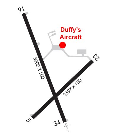
Airport Diagram might not be current. Facility Name: MARSHFIELD MUNI City Name: MARSHFIELD County: WOOD State abbrev: WI State Name: WISCONSIN Ownership: PUBLICLY OWNED Use: OPEN TO THE PUBLIC Owner's Name: CITY OF MARSHFIELD Address: P.O. BOX 727 MARSHFIELD, WI 54449-0727 Owner's Phone: 715-384-2919 Manager's Name: JEFF GAIER Address: 400 W 29TH ST MARSHFIELD, WI 54449 Phone: 715-387-2211 FAA Region: GREAT LAKES FAA Field Office: CHI
Runway Identifications Help
Runway Identification: 05/23 Length: 3597 ftWidth: 100 ftSurface: ASPHALT-FAIR CONDITIONEdge lights: Medium Intensity Treatment: NONE Runway: 05 Runway: 23 Mag heading: 46° Mag heading: 227° Rwy Slope: -.09% Down Rwy Slope: .09% Up Approach: Approach: Pattern: Right Traffic Pattern: Left Traffic Markings: NONPRECISION INSTRUMENT Markings: NONPRECISION INSTRUMENT Marking Condition: GOOD Marking Condition: GOOD Arresting Dev: Arresting Dev: Lat & Long: N4437.9 W09011.6 Lat. & Long.: N4438.3 W09010.9 Elev: 1252.6 ft. MSL Elev: 1249.2 ft. MSL TCH: 29 ft. AGL TCH: Visual Glide Path: 3.00 degrees Visual Glide Path: Displaced Threshold: No Displaced Threshold: No Touchdown Zone: YES Touchdown Zone: YES Touchdown Elev.: 1258.0 feet Touchdown Elev.: 1258.0 feet Visual Glide Slope: 2-Light PAPI on LEFT side of Runway Visual Glide Slope: RVR Equipment: RVR Equipment: RVV Equipment: NO RVV Equipment: NO Approach Lights: Approach Lights: REIL: NO REIL: NO Centerline Lights: NO Centerline Lights: NO Touchdown lights: NO Touchdown lights: NO Runway Category: Runway with a Non-precision Approach Runway Category: Runway with a Non-precision Approach Declared Distances: Declared Distances: Obstructions: TREES Obstructions: Marked: NOT Marked/Lighted Marked: Clearance slope: 8:1 Clearance slope: 20:1 Obstruction height: 35 feet AGL Obstruction height: Dist. from runway: 500 feet Dist. from runway: Centerline offset: 200 left of centerline Centerline offset: Comments: Comments:
Runway Identification: 16/34 Length: 5002 ftWidth: 100 ftSurface: ASPHALT-FAIR CONDITIONEdge lights: Medium Intensity Treatment: NONE Runway: 16 Runway: 34 Mag heading: 159° Mag heading: 339° Rwy Slope: -.45% Down Rwy Slope: .45% Up Approach: Approach: SDF Pattern: Right Traffic Pattern: Left Traffic Markings: NONPRECISION INSTRUMENT Markings: NONPRECISION INSTRUMENT Marking Condition: GOOD Marking Condition: GOOD Arresting Dev: Arresting Dev: Lat & Long: N4438.7 W09011.6 Lat. & Long.: N4437.9 W09011.2 Elev: 1277.8 ft. MSL Elev: 1255.4 ft. MSL TCH: 35 ft. AGL TCH: 42 ft. AGL Visual Glide Path: 3.00 degrees Visual Glide Path: 3.00 degrees Displaced Threshold: No Displaced Threshold: No Touchdown Zone: YES Touchdown Zone: YES Touchdown Elev.: 1277.8 feet Touchdown Elev.: 1258.0 feet Visual Glide Slope: 2-Box VASI on LEFT side of Runway Visual Glide Slope: 2-Box VASI on LEFT side of Runway RVR Equipment: RVR Equipment: RVV Equipment: NO RVV Equipment: NO Approach Lights: Approach Lights: MALSR - 1,400 foot medium intensity approach lighting system with runway alignment indicator lights REIL: YES REIL: NO Centerline Lights: NO Centerline Lights: NO Touchdown lights: NO Touchdown lights: NO Runway Category: Runway with a Non-precision Approach having visibility minimums greater than 3/4 mile Runway Category: D Declared Distances: Declared Distances: Obstructions: TREES Obstructions: TREES Marked: NOT Marked/Lighted Marked: NOT Marked/Lighted Clearance slope: 17:1 Clearance slope: 2:1 Obstruction height: 120 feet AGL Obstruction height: 15 feet AGL Dist. from runway: 2280 feet Dist. from runway: 230 feet Centerline offset: 580 right of centerline Centerline offset: 480 feet left of centerline Comments: Comments: