Current Weather/Notams (Metars, TAFs, Notams, NWS Forecast, PIREPS, and nearby weather)
Customs Information Send updates to Support@FltPlan.com
Customs Not Available
Database effective 04/18/2024
Airport Diagram might not be current.
|
| Facility Name: | MANSFIELD LAHM RGNL |
| City Name: | MANSFIELD |
| County: | RICHLAND |
| State abbrev: | OH |
| State Name: | OHIO |
| | |
| Ownership: | PUBLICLY OWNED |
| Use: | OPEN TO THE PUBLIC |
| Owner's Name: | CITY OF MANSFIELD |
| Address: | 2000 HARRINGTON MEMORIAL RD |
| | MANSFIELD, OH 44903-8051 |
| Owner's Phone: | 419-522-2191 |
| | |
| Manager's Name: | MARK T DAUGHERTY |
| Address: | 2000 HARRINGTON MEMORIAL RD |
| | MANSFIELD, OH 44903-8051 |
| Phone: | 419-522-2191 |
| | |
| FAA Region: | GREAT LAKES |
| FAA Field Office: | DET |
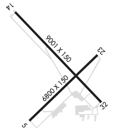
Runway Identifications
Runway Identification: 05/23Length: 6819 ft
Width: 150 ft
Surface: ASPHALT-GOOD CONDITION
Edge lights: High IntensityTreatment: GROOVED
Weight: PCN 55 /F/B/W/U
| | Runway: 05 | | Runway: 23 |
| Mag heading: | 53° | Mag heading: | 233° |
| Rwy Slope: | -.16% Down | Rwy Slope: | .16% Up |
| Approach: | | Approach: | |
| Pattern: | Left Traffic | Pattern: | Left Traffic |
| Markings: | NONPRECISION INSTRUMENT | Markings: | NONPRECISION INSTRUMENT |
| Marking Condition: | FAIR | Marking Condition: | FAIR |
| Arresting Dev: | | Arresting Dev: | |
| Lat & Long: | N4048.7 W08231.5 | Lat. & Long.: | N4049.5 W08230.4 |
| Elev: | 1287.0 ft. MSL | Elev: | 1276.1 ft. MSL |
| TCH: | 50 ft. AGL | TCH: | 45 ft. AGL |
| Visual Glide Path: | 3.00 degrees | Visual Glide Path: | 3.00 degrees |
| Displaced Threshold: | No | Displaced Threshold: | No |
| Touchdown Zone: | YES | Touchdown Zone: | YES |
| Touchdown Elev.: | 1297.0 feet | Touchdown Elev.: | 1294.9 feet |
| Visual Glide Slope: | 4-Light PAPI on LEFT side of Runway | Visual Glide Slope: | 4-Light PAPI on LEFT side of Runway |
| RVR Equipment: | | RVR Equipment: | |
| RVV Equipment: | NO | RVV Equipment: | NO |
| Approach Lights: | | Approach Lights: | |
| REIL: | YES | REIL: | YES |
| Centerline Lights: | NO | Centerline Lights: | NO |
| Touchdown lights: | NO | Touchdown lights: | NO |
| Runway Category: | D | Runway Category: | Runway with a Non-precision Approach having visibility minimums greater than 3/4 mile |
| Declared Distances: | TORA:6819' TODA:6819' ASDA:6819' LDA:6819' | Declared Distances: | TORA:6819' TODA:6819' ASDA:6819' LDA:6819' |
| Obstructions: | | Obstructions: | TREES |
| Marked: | | Marked: | NOT Marked/Lighted |
| Clearance slope: | 50:1 | Clearance slope: | 28:1 |
| Obstruction height: | | Obstruction height: | 48 feet AGL |
| Dist. from runway: | | Dist. from runway: | 1550 feet |
| Centerline offset: | | Centerline offset: | 600 feet right of centerline |
| Comments: | | Comments: | |
Runway Identification: 14/32Length: 9001 ft
Width: 150 ft
Surface: ASPHALT-FAIR CONDITION
Edge lights: High IntensityTreatment: GROOVED
Weight: PCN 62 /F/B/W/U
| | Runway: 14 | | Runway: 32 |
| Mag heading: | 143° | Mag heading: | 323° |
| Rwy Slope: | .49% Up | Rwy Slope: | -.49% Down |
| Approach: | | Approach: | ILS |
| Pattern: | Left Traffic | Pattern: | Left Traffic |
| Markings: | PRECISION INSTRUMENT | Markings: | PRECISION INSTRUMENT |
| Marking Condition: | GOOD | Marking Condition: | GOOD |
| Arresting Dev: | | Arresting Dev: | |
| Lat & Long: | N4050.0 W08231.7 | Lat. & Long.: | N4048.9 W08230.4 |
| Elev: | 1245.5 ft. MSL | Elev: | 1289.7 ft. MSL |
| TCH: | 42 ft. AGL | TCH: | |
| Visual Glide Path: | 3.00 degrees | Visual Glide Path: | |
| Displaced Threshold: | No | Displaced Threshold: | No |
| Touchdown Zone: | YES | Touchdown Zone: | YES |
| Touchdown Elev.: | 1276.3 feet | Touchdown Elev.: | 1293.2 feet |
| Visual Glide Slope: | 4-Light PAPI on LEFT side of Runway | Visual Glide Slope: | |
| RVR Equipment: | ROLLOUT | RVR Equipment: | TOUCHDOWN |
| RVV Equipment: | NO | RVV Equipment: | NO |
| Approach Lights: | | Approach Lights: | MALSR - 1,400 foot medium intensity approach lighting system with runway alignment indicator lights |
| REIL: | NO | REIL: | NO |
| Centerline Lights: | NO | Centerline Lights: | NO |
| Touchdown lights: | NO | Touchdown lights: | NO |
| Runway Category: | D | Runway Category: | Precision Instrument Runway |
| Declared Distances: | TORA:9001' TODA:9001' ASDA:9001' LDA:9001' | Declared Distances: | TORA:9001' TODA:9001' ASDA:9001' LDA:9001' |
| Obstructions: | ROAD | Obstructions: | TREES |
| Marked: | NOT Marked/Lighted | Marked: | NOT Marked/Lighted |
| Clearance slope: | 34:1 | Clearance slope: | 42:1 |
| Obstruction height: | 27 feet AGL | Obstruction height: | 58 feet AGL |
| Dist. from runway: | 1143 feet | Dist. from runway: | 2650 feet |
| Centerline offset: | 629 right of centerline | Centerline offset: | 250 feet right of centerline |
| Comments: | | Comments: | |

