Current Weather/Notams (Metars, TAFs, Notams, NWS Forecast, PIREPS, and nearby weather)
Customs Information Send updates to Support@FltPlan.com
Customs Not Available
Database effective 04/18/2024
Airport Diagram might not be current.
|
| Facility Name: | MEADE MUNI |
| City Name: | MEADE |
| County: | MEADE |
| State abbrev: | KS |
| State Name: | KANSAS |
| | |
| Ownership: | PUBLICLY OWNED |
| Use: | OPEN TO THE PUBLIC |
| Owner's Name: | CITY OF MEADE; DEAN CORDES - CITY ADMINISTRATOR. |
| Address: | PO BOX 338 |
| | MEADE, KS 67864 |
| Owner's Phone: | 620-873-2091 |
| | |
| Manager's Name: | DEAN CORDES |
| Address: | PO BOX 338 |
| | MEADE, KS 67864 |
| Phone: | 620-873-2091; CRAIG STRATTON, BRINGHAM FLYING SVC-FBO 620-873-5191. |
| | |
| FAA Region: | CENTRAL |
| FAA Field Office: | NONE |
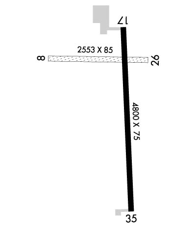
Runway Identifications
Runway Identification: 08/26Length: 2085 ft
Width: 85 ft
Surface: GRASS-GOOD CONDITION
Edge lights: Treatment: NONE
| | Runway: 08 | | Runway: 26 |
| Mag heading: | 82° | Mag heading: | 262° |
| Rwy Slope: | -.78% Down | Rwy Slope: | .78% Up |
| Approach: | | Approach: | |
| Pattern: | Left Traffic | Pattern: | Left Traffic |
| Markings: | NONE | Markings: | NONE |
| Marking Condition: | GOOD | Marking Condition: | GOOD |
| Arresting Dev: | | Arresting Dev: | |
| Lat & Long: | N3716.9 W10021.7 | Lat. & Long.: | N3716.9 W10021.3 |
| Elev: | 2527.0 ft. MSL | Elev: | 2510.7 ft. MSL |
| TCH: | | TCH: | |
| Visual Glide Path: | | Visual Glide Path: | |
| Displaced Threshold: | No | Displaced Threshold: | No |
| Touchdown Zone: | YES | Touchdown Zone: | YES |
| Touchdown Elev.: | 2527.0 feet | Touchdown Elev.: | 2527.0 feet |
| Visual Glide Slope: | | Visual Glide Slope: | |
| RVR Equipment: | | RVR Equipment: | |
| RVV Equipment: | NO | RVV Equipment: | NO |
| Approach Lights: | | Approach Lights: | |
| REIL: | NO | REIL: | NO |
| Centerline Lights: | NO | Centerline Lights: | NO |
| Touchdown lights: | NO | Touchdown lights: | NO |
| Runway Category: | Runway with a Visual Approach | Runway Category: | Runway with a Visual Approach |
| Declared Distances: | | Declared Distances: | |
| Obstructions: | ROAD | Obstructions: | POLE |
| Marked: | NOT Marked/Lighted | Marked: | NOT Marked/Lighted |
| Clearance slope: | 16:1 | Clearance slope: | 38:1 |
| Obstruction height: | 17 feet AGL | Obstruction height: | 7 feet AGL |
| Dist. from runway: | 284 feet | Dist. from runway: | 272 feet |
| Centerline offset: | | Centerline offset: | |
| Comments: | | Comments: | |
Runway Identification: 17/35Length: 4800 ft
Width: 75 ft
Surface: CONCRETE-FAIR CONDITION
Edge lights: Medium IntensityTreatment: NONE
Weight: PCN 11 /R/C/X/U
| | Runway: 17 | | Runway: 35 |
| Mag heading: | 168° | Mag heading: | 348° |
| Rwy Slope: | -.30% Down | Rwy Slope: | .30% Up |
| Approach: | | Approach: | |
| Pattern: | Left Traffic | Pattern: | Left Traffic |
| Markings: | NONPRECISION INSTRUMENT | Markings: | NONPRECISION INSTRUMENT |
| Marking Condition: | FAIR | Marking Condition: | FAIR |
| Arresting Dev: | | Arresting Dev: | |
| Lat & Long: | N3717.0 W10021.4 | Lat. & Long.: | N3716.2 W10021.3 |
| Elev: | 2518.1 ft. MSL | Elev: | 2503.5 ft. MSL |
| TCH: | 32 ft. AGL | TCH: | 38 ft. AGL |
| Visual Glide Path: | 3.00 degrees | Visual Glide Path: | 3.00 degrees |
| Displaced Threshold: | No | Displaced Threshold: | No |
| Touchdown Zone: | YES | Touchdown Zone: | YES |
| Touchdown Elev.: | 2518.1 feet | Touchdown Elev.: | 2513.7 feet |
| Visual Glide Slope: | 2-Light PAPI on LEFT side of Runway | Visual Glide Slope: | 2-Light PAPI on LEFT side of Runway |
| RVR Equipment: | | RVR Equipment: | |
| RVV Equipment: | NO | RVV Equipment: | NO |
| Approach Lights: | | Approach Lights: | |
| REIL: | YES | REIL: | YES |
| Centerline Lights: | NO | Centerline Lights: | NO |
| Touchdown lights: | NO | Touchdown lights: | NO |
| Runway Category: | Runway with a Non-precision Approach | Runway Category: | Runway with a Non-precision Approach |
| Declared Distances: | | Declared Distances: | |
| Obstructions: | ROAD | Obstructions: | ROAD |
| Marked: | NOT Marked/Lighted | Marked: | NOT Marked/Lighted |
| Clearance slope: | 37:1 | Clearance slope: | 30:1 |
| Obstruction height: | 10 feet AGL | Obstruction height: | 10 feet AGL |
| Dist. from runway: | 575 feet | Dist. from runway: | 500 feet |
| Centerline offset: | | Centerline offset: | |
| Comments: | | Comments: | |

