Click here for more info on on SMS!

KMDW

CHICAGO MIDWAY INTL
CHICAGO
IL
Time Zone: Central
Lat: N 4147.2
Long: W 08745.1
Elev: 620
Var: +04
Longest Runway: 6522
Clr Del: 124.62
Dept. ATIS: 132.75
Arr. ATIS: 132.75
AWOS: 132.75
Ground: 118.07
Tower: 135.2

FBO & Flight Services info for KMDW

FBOs: Update your Fuel Prices
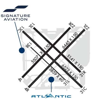
Atlantic Aviation is your premier aviation service provider with more than 100 locations in North America, including Hawaii and the Caribbean. We provide standard ground services you'd expect, with a detailed focus on ensuring an unforgettable customer experience.
Ph: 773-582-5720 Fax: 773-582-1047 Freq: 131.42WebsiteE-Mail
                             
Service
Jet
100LL
SAF
MoGas
Fuel Avail: 24/7 Call for current pricing
Full8.788.47    Last Update: 04/23/2024 13:22:07

Self        
Misc. Info: All prices are 'Out The Door', call for volume discountsAddress: 6150 S. LARAMIE AVENUE,   CHICAGO, IL 60638

  click here  
According to one story, Chicago didn't get its nickname 'Windy City' from the gusty weather. The name was coined more than 100 years ago by a visiting reporter who noticed Chicagoans couldn't stop boasting about their town. Residents can still brag about their city, considered one of the most successful metropolitan areas in the US. Let Signature-MDW be your guide to the best that Chicago offers.
Ph: 773-767-4400 Fax: 773-767-5822 Freq: 128.92WebsiteE-Mail
                     
Service
Jet
100LL
SAF
MoGas
Fuel Avail: Jet A w/Prist, add $0.06 per gallon.
Full8.788.99    Last Update: 04/23/2024 09:38
PRICES GUARANTEED by FBO.
Self        
Misc. Info: Address: 5821 SOUTH CENTRAL AVE.,   CHICAGO, IL 60638

DUNCAN AVIONICSPh: 773-284-4600 Fax: N/A
-
ATISPh: 773-581-9967
-
-
 
ASOSPh: 773-581-8094
-
-
 
If you are an FBO, call 1-203-262-1700 to update your info or email: FltPlan.Advertising@garmin.com
Advertise your FBO on FltPlan.com

Runway & Approach Info for KMDW
Rwy
Length
Land Dist**
Approach*
  Rwy
Length
Land Dist**
Approach*
04L
5507x150  4749'          
 
  
22R
  5507x150  4629'          
 
04R
6445x150  5927'          
ILS/DME
 111.50 - 047°  
  
22L
  6445x150  5810'          
 
13C
6522x150  6059'          
ILS/DME
 109.90 - 137°  
  
31C
  6522x150  5826'          
ILS/DME
 109.90 - 317°  
13L
5141x150  4389'          
 
  
31R
  5141x150  5141'          
 
13R
3859x60  3859'          
 
  
31L
  3859x60  3859'          
 
 * only ILS, LOC, LDA, and SDF approaches to a specific runway are shown
** For any Declared Landing Distance Available, please see A/FD or Approach plates
Runway Weight Capability (lbs.) Help
Runway IDSingle WheelDouble WheelDouble Tandem WheelDual Double Wheel
04L/22R60,000120,000N/AN/A
04R/22L95,000165,000250,000N/A
13C/31C95,000165,000250,000N/A
13L/31R80,000125,000N/AN/A
13R/31L12,500N/AN/AN/A
These numbers are Advisory and are not limits.   The Airport Manager should have more accurate Weight Limits
Approach Charts
Approaches    
Current Weather/Notams
Customs Information Send updates to Support@FltPlan.com
Phone 773-948-6330
Fax 773-948-6239

Comments on-Fri 0830-1700 *1 hr advance notice required 2 hrs after hours *Maximum passengers per flight: 20 *Call prior to 1700 on preceding day.
Database effective 05/16/2024
Airport Diagram of KMDW
Airport Diagram might not be current.

Facility Name: CHICAGO MIDWAY INTL
City Name: CHICAGO
County: COOK
State abbrev: IL
State Name: ILLINOIS
   
Ownership: PUBLICLY OWNED
Use: OPEN TO THE PUBLIC
Owner's Name: CITY OF CHICAGO
Address: 5700 S. CICERO
 CHICAGO, IL 60638
Owner's Phone: 773-838-0608
  
Manager's Name: JAMIE RHEE
Address: 10510 WEST ZEMKE ROAD
 CHICAGO, IL 60666
Phone: 773-894-5492; ARPT OPNS 773-838-0677.
   
FAA Region: GREAT LAKES
FAA Field Office: CHI


Sunrise / Sunset times for CHICAGO MIDWAY INTL

DateSunriseSunset
04/22/24 Monday5:5919:40
04/23/24 Tuesday5:5819:42
04/24/24 Wednesday5:5619:43
04/25/24 Thursday5:5519:44
04/26/24 Friday5:5319:45
04/27/24 Saturday5:5219:46
04/28/24 Sunday5:5019:47
04/29/24 Monday5:4919:48
04/30/24 Tuesday5:4819:49
05/01/24 Wednesday5:4619:50
05/02/24 Thursday5:4519:51
05/03/24 Friday5:4419:52
05/04/24 Saturday5:4319:53
05/05/24 Sunday5:4119:55

Airport Facilities

Airport Attendance ScheduleCONTINUOUS
Airport Status OPERATIONAL (This Status can change at any time - please check NOTAMS)
Airport Lighting Schedule
Airport Storage AvailableTie Downs, Hanger
Extra Services AvailableAir Freight, Air Ambulance, Avionics, Cargo Handling, Charter, Flight Instruction
Wind IndicatorYES - (lighted)
Control TowerYES
CTAF Frequency
Unicom Frequency122.950
Rotating Beacon ColorWG
Segmented CircleNO
Landing FeeNO

Airport Inspection Data

Airport InspectedFEDERAL - performed by FAA AIRPORTS FIELD PERSONNEL
Inspection Date08/30/2023

Airport Services

Type of Fuel AvailableGrade 100LL, JET A-1 (icing inhibitor, freeze point -50C)
Airframe Repair ServiceMAJOR
Power Plant Repair ServiceMAJOR

Geographic Data

LatitudeN4147.2
LongitudeW08745.1 (ESTIMATED)
Arpt Elevation619ft (SURVEYED)
Magnetic Variation04W
9 miles SWof CHICAGO
Traffic Pattern Altitude
Sectional ChartCHICAGO

Aircraft Data

Operations (Reported)YearlyAvg. Daily
General Aviation Transient 2834778
General Aviation Local 00
Air Taxi 2877379
Commerical 156978430
Commuter 00
Military 3291
Aircraft based on Field
General Aviation Singles 7
General Aviation Multi 0
Jet Aircraft 26
General Aviation Helicopters 0
Military Aircraft 0
Gliders 0
Ultralights 0

FAA Services

FSS on field NO
FSS tie-in KANKAKEE
FSS Phone 1-800-WX-BRIEF
Who issues Notams MDW
Notam D service at airport YES
ARTCC Name CHICAGO

Federal Status

Airport CertificationAIRPORT RECEIVING SCHEDULED AIR CARRIER SERVICE FROM CARRIERS CERTIFICATED BY THE CIVIL AERONAUTICS BOARD; ARFF INDEX "D" EQPT AVBL WITH 8 HRS NOTIFICATION TO ARPT OPNS 773-838-0677.
Aircraft Rescue & Firefighting IndexAIRPORT HAS A CERTIFICATE UNDER CFR PART 139
Airport of EntryYES
Custom Landing RightsNo
Joint Civil/MilitaryNo
Military Landing rightsYES

Federal Agreements

NATIONAL PLAN OF INTEGRATED AIRPORT SYSTEMS (NPIAS)
GRANT AGREEMENTS UNDER FAAP/ADAP/AIP
ASSURANCES PURSUANT TO TITLE VI, CIVIL RIGHTS ACT OF 1964
AGREEMENT UNDER DLAND OR DCLA HAS EXPIRED.

Remarks

TWY A CLSD TO ACFT OVR 94 FT WINGSPAN.
ASDE-X IN USE. OPERATE TRANSPONDERS WITH ALTITUDE REPORTING MODE AND ADS-B (IF EQUIPPED) ENABLED ON ALL AIRPORT SURFACES.
TWY F CLSD TO ACFT OVR 94 FT WINGSPAN.
RY 13R/31L CLSD TO FLT OPS WHEN ACFT OVR 79 FT WINGSPAN ARE ON TWY F.
NOISE ABATEMENT PROCEDURES: ALL DEPARTURES ARE REQUESTED TO EXPEDITE CLIMB THROUGH 1500 FT MSL 2200-0600 DLY.
TWY N CLSD BTN TWY Y AND RWY 22L PAD.
ARPT CLSD TO SOLO STUDENT TRAINING.
BIRDS ON & INVOF ARPT.
CLOSE-IN OBST ALL RYS EXCEPT RY 13R/31L TOO NUMEROUS TO ITEMIZE.
RY 22L PREFERRED DEP RY 2200-0700.
RWY 13R/ 31LRWYS 13R/31L & 04L/22R NOT AVBL FOR SKEDD ACR OPNS WITH MORE THAN 9 PSGR SEATS OR UNSKED ACR AT LEAST 31 PSGR SEATS.
Airport Communications & Frequencies:
ATIS Frequencies:   Hours(local) of Operation: CONTINUOUS
132.75
MIDWAY Tower Frequencies:   Hours(local) of operation: CONTINUOUS   
135.2
269.125
MIDWAY Ground Frequencies:
118.075
Clearance Delivery Frequencies:
124.625
Emergency Frequencies:
121.5
Unicom Frequency:
122.950
CHICAGO Primary Approach Frequencies:  
128.2
353.875
Part-time Approach Frequencies:  
126.05
CHICAGO Primary Departure Frequencies:  
128.2
353.875
Part-time Departure Frequencies:  
126.05
Class C Frequencies:
119.45
135.2
269.125
Runway Identifications
Runway Identification: 04L/22R
Length: 5507 ft
Width: 150 ft
Surface: ASPHALT-GOOD CONDITION
Edge lights: Medium Intensity

Treatment: GROOVED
Weight: PCN 69 /F/D/X/T

 Runway: 04L   Runway: 22R
Mag heading: 47°Mag heading: 227°
Rwy Slope: -.24% DownRwy Slope: .24% Up
Approach: Approach:
Pattern: Left TrafficPattern: Left Traffic
Markings: NONPRECISION INSTRUMENTMarkings: NONPRECISION INSTRUMENT
Marking Condition: GOODMarking Condition: GOOD
Arresting Dev: Arresting Dev:
Lat & Long: N4146.9  W08745.7Lat. & Long.: N4147.5  W08744.8
Elev: 618.5 ft. MSLElev: 605.2 ft. MSL
TCH: 39 ft. AGLTCH: 35 ft. AGL
Visual Glide Path: 3.00 degreesVisual Glide Path: 3.00 degrees
Displaced Threshold: 758 feetDisplaced Threshold: 878 feet
Touchdown Zone: YESTouchdown Zone: YES
Touchdown Elev.: 617.2 feetTouchdown Elev.: 613.5 feet
Visual Glide Slope: 4-Light PAPI on LEFT side of RunwayVisual Glide Slope: 4-Light PAPI on LEFT side of Runway
RVR Equipment: RVR Equipment:
RVV Equipment: NORVV Equipment: NO
Approach Lights: Approach Lights:
REIL: NOREIL: NO
Centerline Lights: NOCenterline Lights: NO
Touchdown lights: NOTouchdown lights: NO
Runway Category: Runway with a Non-precision Approach having visibility minimums greater than 3/4 mileRunway Category: Runway with a Non-precision Approach having visibility minimums greater than 3/4 mile
Declared Distances: TORA:5507' TODA:5507' ASDA:5507' LDA:4749'Declared Distances: TORA:5507' TODA:5507' ASDA:5507' LDA:4629'
Obstructions: ROADObstructions: ROAD
Marked: NOT Marked/LightedMarked: NOT Marked/Lighted
Clearance slope: RWY 04L APCH RATIO 19:1 AT DSPLCD THLD. TREES 178 FT L 1313 FT FROM DSPLCD THLD.Clearance slope: RWY 22R APCH RATIO 37:1 AT DSPLCD THR. TREE 2490 FT FROM DSPLCD THR 319 FT L.
Obstruction height: 15 feet AGLObstruction height: 15 feet AGL
Dist. from runway: 200 feetDist. from runway: 200 feet
Centerline offset: 25 left of centerlineCenterline offset: 125 feet right of centerline
Comments: Comments:
Runway Identification: 04R/22L
Length: 6445 ft
Width: 150 ft
Surface: CONCRETE ASPHALT
Edge lights: High Intensity

Treatment: GROOVED
Weight: PCN 62 /F/D/X/T

 Runway: 04R   Runway: 22L
Mag heading: 47°Mag heading: 227°
Rwy Slope: -.22% DownRwy Slope: .22% Up
Approach: ILS/DMEApproach:
Pattern: Left TrafficPattern: Left Traffic
Markings: PRECISION INSTRUMENTMarkings: PRECISION INSTRUMENT
Marking Condition: GOODMarking Condition: GOOD
Arresting Dev: EMAS; ENGINEERED MATERIALS ARRESTING SYSTEM (EMAS) 249 FT IN LENGTH BY 170 FT IN WIDTH LCTD AT THE DER 04R.Arresting Dev: EMAS; ENGINEERED MATERIALS ARRESTING SYSTEM (EMAS) 346 FT IN LENGTH BY 170 FT IN WIDTH LCTD AT THE DER 22L.
Lat & Long: N4146.7  W08745.6Lat. & Long.: N4147.5  W08744.6
Elev: 619.7 ft. MSLElev: 605.2 ft. MSL
TCH: 66 ft. AGLTCH: 43 ft. AGL
Visual Glide Path: 3.00 degreesVisual Glide Path: 3.00 degrees
Displaced Threshold: 518 feetDisplaced Threshold: 635 feet
Touchdown Zone: YESTouchdown Zone: YES
Touchdown Elev.: 619.2 feetTouchdown Elev.: 611.0 feet
Visual Glide Slope: 4-Light PAPI on LEFT side of RunwayVisual Glide Slope: 4-Light PAPI on RIGHT side of Runway
RVR Equipment: TOUCHDOWN-ROLLOUTRVR Equipment: TOUCHDOWN-ROLLOUT
RVV Equipment: NORVV Equipment: NO
Approach Lights: Approach Lights:
REIL: YESREIL: YES
Centerline Lights: YESCenterline Lights: YES
Touchdown lights: NOTouchdown lights: NO
Runway Category: Precision Instrument RunwayRunway Category: Runway with a Non-precision Approach having visibility minimums greater than 3/4 mile
Declared Distances: TORA:6446' TODA:6446' ASDA:6446' LDA:5928'Declared Distances: TORA:6446' TODA:6446' ASDA:6446' LDA:5812'
Obstructions: ROADObstructions: ROAD
Marked: NOT Marked/LightedMarked: NOT Marked/Lighted
Clearance slope: RWY 04R APCH RATIO 16:1 AT DSPLCD THLD. TREE 547 FT R 1122 FT FROM DSPLCD THLD.Clearance slope: RWY 22L APCH RATIO 19:1 AT DSPLCD THLD. LGT POLE 474 FT R 674 FT FROM DSPLCD THLD.
Obstruction height: 15 feet AGLObstruction height: 15 feet AGL
Dist. from runway: 200 feetDist. from runway: 200 feet
Centerline offset: 325 right of centerlineCenterline offset: 350 feet left of centerline
Comments: Comments:
Runway Identification: 13C/31C
Length: 6522 ft
Width: 150 ft
Surface: CONCRETE ASPHALT
Edge lights: High Intensity

Treatment: GROOVED
Weight: PCN 61 /F/D/X/T

 Runway: 13C   Runway: 31C
Mag heading: 138°Mag heading: 318°
Rwy Slope: .07% UpRwy Slope: -.07% Down
Approach: ILS/DMEApproach: ILS/DME
Pattern: Left TrafficPattern: Left Traffic
Markings: PRECISION INSTRUMENTMarkings: PRECISION INSTRUMENT
Marking Condition: GOODMarking Condition: GOOD
Arresting Dev: EMAS; ENGINEERED MATERIALS ARRESTING SYSTEM (EMAS) 190 FT IN LENGTH BY 170 FT IN WIDTH LCTD AT THE DER 13C.Arresting Dev: EMAS; ENGINEERED MATERIALS ARRESTING SYSTEM (EMAS) 210 FT IN LENGTH BY 170 FT IN WIDTH LCTD AT THE DER 31C.
Lat & Long: N4147.5  W08745.7Lat. & Long.: N4146.8  W08744.6
Elev: 607.0 ft. MSLElev: 611.6 ft. MSL
TCH: 47 ft. AGLTCH: 63 ft. AGL
Visual Glide Path: 3.00 degreesVisual Glide Path: 3.00 degrees
Displaced Threshold: 463 feetDisplaced Threshold: 696 feet
Touchdown Zone: YESTouchdown Zone: YES
Touchdown Elev.: 610.6 feetTouchdown Elev.: 612.7 feet
Visual Glide Slope: 4-Light PAPI on RIGHT side of RunwayVisual Glide Slope: 4-Light PAPI on LEFT side of Runway
RVR Equipment: TOUCHDOWN-ROLLOUTRVR Equipment: TOUCHDOWN-ROLLOUT
RVV Equipment: NORVV Equipment: NO
Approach Lights: RLLSApproach Lights: RLLS
REIL: NOREIL: YES
Centerline Lights: YESCenterline Lights: YES
Touchdown lights: NOTouchdown lights: NO
Runway Category: Precision Instrument RunwayRunway Category: Precision Instrument Runway
Declared Distances: TORA:6522' TODA:6522' ASDA:6522' LDA:6059'Declared Distances: TORA:6522' TODA:6522' ASDA:6522' LDA:5826'
Obstructions: ROADObstructions: ROAD
Marked: NOT Marked/LightedMarked: NOT Marked/Lighted
Clearance slope: RWY 13C APCH RATIO 16:1 AT DSPLCD THLD. TREE 453 FT R 915 FT FROM DSPLCD THLD.Clearance slope: RWY 31C APCH RATIO 24:1 AT DSPLCD THR. TREE 1211 FT FROM DSPLCD THR 459 FT R.
Obstruction height: 15 feet AGLObstruction height: 47 feet AGL
Dist. from runway: 200 feetDist. from runway: 200 feet
Centerline offset: 225 right of centerlineCenterline offset: 225 feet left of centerline
Comments: Comments:
Runway Identification: 13L/31R
Length: 5141 ft
Width: 150 ft
Surface: CONCRETE ASPHALT-GOOD CONDITION
Edge lights: Medium Intensity

Treatment: GROOVED
Weight: PCN 59 /R/B/W/T

 Runway: 13L   Runway: 31R
Mag heading: 138°Mag heading: 318°
Rwy Slope: .04% UpRwy Slope: -.04% Down
Approach: Approach:
Pattern: Left TrafficPattern: Left Traffic
Markings: NONPRECISION INSTRUMENTMarkings: NONPRECISION INSTRUMENT
Marking Condition: GOODMarking Condition: GOOD
Arresting Dev: Arresting Dev:
Lat & Long: N4147.5  W08745.5Lat. & Long.: N4147.0  W08744.7
Elev: 606.1 ft. MSLElev: 608.3 ft. MSL
TCH: TCH: 44 ft. AGL
Visual Glide Path: Visual Glide Path: 3.00 degrees
Displaced Threshold: 752 feetDisplaced Threshold: No
Touchdown Zone: YESTouchdown Zone: YES
Touchdown Elev.: 609.1 feetTouchdown Elev.: 609.9 feet
Visual Glide Slope: Visual Glide Slope: 4-Light PAPI on LEFT side of Runway
RVR Equipment: RVR Equipment:
RVV Equipment: NORVV Equipment: NO
Approach Lights: Approach Lights:
REIL: NOREIL: NO
Centerline Lights: NOCenterline Lights: NO
Touchdown lights: NOTouchdown lights: NO
Runway Category: Runway with a Non-precision Approach having visibility minimums greater than 3/4 mileRunway Category: Runway with a Non-precision Approach having visibility minimums greater than 3/4 mile
Declared Distances: Declared Distances:
Obstructions: ROADObstructions: POLE
Marked: NOT Marked/LightedMarked: LIGHTED
Clearance slope: Clearance slope: 13:1
Obstruction height: 15 feet AGLObstruction height: 34 feet AGL
Dist. from runway: 200 feetDist. from runway: 656 feet
Centerline offset: Centerline offset: 285 feet right of centerline
Comments: Comments:
Runway Identification: 13R/31L
Length: 3859 ft
Width: 60 ft
Surface: ASPHALT
Edge lights: Medium Intensity

Treatment: NONE
Weight: PCN 42 /R/B/X/T

 Runway: 13R   Runway: 31L
Mag heading: 138°Mag heading: 318°
Rwy Slope: .16% UpRwy Slope: -.16% Down
Approach: Approach:
Pattern: Left TrafficPattern: Left Traffic
Markings: BASICMarkings: BASIC
Marking Condition: GOODMarking Condition: GOOD
Arresting Dev: Arresting Dev:
Lat & Long: N4147.3  W08745.5Lat. & Long.: N4146.8  W08744.9
Elev: 606.9 ft. MSLElev: 612.9 ft. MSL
TCH: TCH:
Visual Glide Path: Visual Glide Path:
Displaced Threshold: NoDisplaced Threshold: No
Touchdown Zone: YESTouchdown Zone: YES
Touchdown Elev.: 611.7 feetTouchdown Elev.: 613.0 feet
Visual Glide Slope: Visual Glide Slope:
RVR Equipment: RVR Equipment:
RVV Equipment: NORVV Equipment: NO
Approach Lights: Approach Lights:
REIL: NOREIL: NO
Centerline Lights: NOCenterline Lights: NO
Touchdown lights: NOTouchdown lights: NO
Runway Category: Runway with a Visual ApproachRunway Category: Runway with a Visual Approach
Declared Distances: Declared Distances:
Obstructions: TREEObstructions: TREE
Marked: NOT Marked/LightedMarked: NOT Marked/Lighted
Clearance slope: 23:1Clearance slope: 26:1
Obstruction height: 55 feet AGLObstruction height: 59 feet AGL
Dist. from runway: 1504 feetDist. from runway: 1737 feet
Centerline offset: 214 right of centerlineCenterline offset: 147 feet right of centerline
Comments: Comments:
C:306/P: